Saturday, 24 June 2023

Exmoor - Watchet and Clifton Suspension bridge
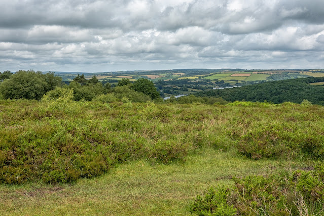
Our last day and the start of our drive home, I have included together. We decided to visit Haddon Hill on our last day on Exmoor.
As one of the higher points in the southwest of Exmoor National Park, overlooking Wimbleball Reservoir. Haddon Hill provides an accessible way to experience Exmoor's wide-open moorlands. It is a wonderful place to see the herd of free roaming Exmoor Ponies that live here. The heather and gorse provide a habitat for many species of insect and during the summer, including the rare heath fritillary. With the possibility of seeing this particular butterfly, this was our first stop. We set out on the most obvious trail, and yes, there were the ponies - which kindly moved out of the way!
Apart from that, the walk was somewhat of a disappointment, for the heather and gorse - not a flower in sight and obviously not a butterfly either. A pleasant walk looking across the moorland down toward the reservoir but otherwise not what we had hoped for.


As there was no point in lingering here, we set off to Watchet - a small coastal town with an active marina and some quaint houses - apparently.


So, here is the marina - and the tide is out! 
 
 
The entrance to the harbour with the lighthouse and then to a walk along the promonade.


Samual Taylor Coleridge


On the promenade were two interesting statues, the one above is probably better known because the Ancient Mariner must be part of most children's schooling. As mentioned earlier, we visited Nether Stowey at the start of this holiday. 
The statue below is of a man who is new to me, but obviously this area was his home.


John Short, also known as Yankee Jack, was a sailor from Watchet. He was a prolific singer and between April and June 1914 Cecil Sharp collected 57 sea shanties from him, making him one of the largest donors of song material in Sharp’s Quantock journeys. Sharp published a book English Folk-Chanteys, containing 60 songs, 46 of which were collected from John, making him incredibly important to English sea shanty history.

[Cecil James Sharp (22 November 1859 – 23 June 1924) was an English collector of folk songs, folk dances and instrumental music, as well as a lecturer, teacher, composer and musician. He was a key figure in the folk-song revival in England during the Edwardian period.]

Born in 1839, John was employed on a number of ships in his career, sailing as far away as the Far East, Peru, India, and North America. He was often employed as what was known as a “Shantyman” on ship, to keep the crew working in rhythm. Therefore, we know his songs are ones authentically used on ships.
As well as a prolific singer, John was at the heart of the Watchet community, later becoming Town Crier. A statue by Alan Herriott was erected in his honour on the seafront in 2008. He died in 1933, so by the time he met Cecil Sharp he was 76 and retired from his life at sea. This also means that the songs he shared were those known to be sung in the mid 19th century and probably went back much further. He was a true local man who in his long life saw the world, but it is the heritage of the ocean brought back to the Severn Sea, that gives him his place in national folk as well as Quantock history.


I saw this on the front door of a house, so I had to get the photo!

That was it for this holiday in Somerset, and very enjoyable it was too. Next morning, we set off with the aim of stopping to see the Clifton Suspension Bridge in Bristol. The following few images are taken of the bridge.


The bridge is built to a design by William Henry Barlow and John Hawkshaw, based on an earlier design by Isambard Kingdom Brunel. It is a Grade I listed building and forms part of the B3129 road.
The idea of building a bridge across the Avon Gorge originated in 1753. Original plans were for a stone bridge and later iterations were for a wrought iron structure. In 1831, an attempt to build Brunel's design was halted by the Bristol riots, and the revised version of his designs was built after his death and completed in 1864.


I thought the river looked a bit murky!


Really interesting to see and to marvel at the brilliance of those who design such structures. The bridge is a Grade I listed building and forms part of the B3129 road.


Thursday, 22 June 2023

Exmoor - Valley of the Rocks

Today we are off to the Lynton and Lynmouth area, to The Valley of the Rocks to be precise. The Valley of Rocks is a Site of Special Scientific Interest and a Site of Special Geological Interest and a `must see` as a tourist.
But before I show some images of the area, I would mention that our route took us along the A39 and up Porlock Hill.
Wikipedia sums it up: Porlock Hill is a road west of Porlock, Somerset. It is part of the A39, connecting Porlock to Lynmouth and Barnstaple in Devon and is the steepest A-road in the United Kingdom, approaching 1 in 4 (25%) in places. A parallel toll road is available which travels the same route at an easier gradient. - If only I had known! Never mind, it was an experience!


We stopped at this point, firstly in relief and secondly to admire the fantastic view! It was called Foreland Point and was a wonderful place to admire the view and watch the mist rolling across the hills.


Foreland Point


We had parked the car a short distance from the Valley of the Rocks at the edge of this cricket ground which was Lynton & Lynmouth Cricket Ground - what a spot!


AS we approached the coast, we began to see the wild goats lazing in the sun just ahead of us. Apparently, the goats are even mentioned in the Domesday Book and in the novel Lorna Doone.
To ensure its conservation, the unusual and rare herd has been supported by the Lynton Feral Goat Preservation Society since 1997.


As for the scenery - magical I would say. Well worth the visit.


As we wandered, we were able to see more of the wild goats strolling around their territory.


We then walked back along the coastal path to Lynton, passing the Lynton and Lynmouth funicular Cliff Railway.The multi-award winning and famous Lynton and Lynmouth funicular Cliff Railway opened in 1890 and is the highest and the steepest totally water powered railway in the world! How does this work I thought?

"The Lift works on a simple balancing principle. The two cars are permanently attached to each other by hauling cables that run around a huge 5ft 6" pulley wheel at the top and the bottom of the tracks. There are four cables in total; two hauling cables that carry the weight of the cars and two tail balancing cables that counteract the weight of the hauling cables.
When each car is ‘docked’ with full water tanks the cars are in balance and are ready for loading. Each tank holds 700 gallons of water. As passengers board, variations are accommodated for by the brakes which clamp the cars to the rails. Each car's brakes will hold the weight of both cars fully laden, and the lower car has a water operated locking device which clamps the car to the bottom station. The company was formed in 1888 through an act of Parliament with perpetual rights to extract water from the West Lyn River.
When loaded, the drivers use pre-arranged bell signals, unlock the safety lock, and release the brakes. The lower driver discharges water until the top car is heavier. Sometimes this is achieved with the weight of passengers alone and no water is used. The top car then rolls down the rails pulling the lower car up.
Each car has two sets of water operated brakes. The ‘governor’, which in turn, is driven by the main wheels operates one set. The brake shoes press down on the top surface of the rail and lift the car off the rail by 2mm, thereby using the weight of the car to provide friction between the rail and the brake shoes. The other set of brakes work in reverse to a conventional brake system, the brakes are permanently on and operated by a large water accumulator via the driver's hand wheel 'The Deadman's Handle'. This means when the cars are unattended, the brakes clamp it to the rails making it impossible to move under any circumstances and the driver has to hold the brakes off during the journey."

So now you know!


Countisbury on the way back home - I think.


Wednesday, 21 June 2023

Exmoor - Cleeve Abbey & Crowcombe Church

Cleeve Abbey in Somerset housed a community of Cistercian monks for almost 350 years. At its peak it was home to 28 monks. Between 1186 and 1191 William de Roumare, Earl of Lincoln, gave all his lands at Cleeve for the foundation of a Cistercian abbey.
The first abbot and his monks arrived in 1198 from Revesby Abbey in Lincolnshire, which had itself been founded by William’s grandfather. Cleeve was originally called ‘Vallis Florida’ (valley of flowers) and it soon attracted further gifts, mainly of land, from other local aristocrats.
When William founded the abbey, it was partly out of religious belief and partly out of self-interest. Founding an abbey was expensive, but medieval people believed that many prayers were needed to avoid a long stay in purgatory, or worse still descent into hell. It was thought that the best people to pray were the men and women – monks and nuns – who led a perfect Christian life dedicated to God.

After the abbey’s suppression in 1536 the church was destroyed, but the cloister survived virtually intact. Considering the size of this site, and the lavish building that it seems to have been, it seems criminal to me, centuries later, that this housed just 28 monks!
Although lots of it are now just traces, you can still get a feeling of its huge size.
So, here are some of my images of the day starting with the Gatehouse which is still largely intact.


The 13th century Gatehouse, remodeled by Abbot Dovell in the early 16th century. He was the last Abbot, I believe.


The angel roof of the 15th century refectory


The painted chamber at Cleeve (which was probably the office of the abbot, where his clerks worked) derives its name from the large, late 15th-century wall painting that covers one wall. It was rather unfortunate, albeit understandable, that we had to look at the painting from a side window, but the image gives some idea of the wall.
Unparalleled elsewhere in Britain, the painting shows a richly dressed, bearded old man praying on a bridge. He is flanked on one side by a lion and St Catherine of Alexandria (holding a wheel, the symbol of her martyrdom) and on the other side by a dragon and St Margaret of Antioch (who is impaling a second dragon with her staff). Fishes and large eels swim in the water below the bridge, while flying angels are represented in black and red outline, holding instruments of Christ’s Passion – the crown of thorns and the scourge.
The subject of the painting has recently been identified as the legend of a man crossing a bridge from the Gesta Romanorum (‘Deeds of the Romans’), a popular medieval collection of religious tales. A bit difficult to make it out from our viewpoint however!


A couple of images of the outside of the Abbey, the bottom one showing the outline of what was the church.

The village of Crowcombe nestles into the western slopes of the Quantock Hills south-east of Williton. In the centre of the village, beside the stately home of Crowcombe Court, stands the medieval Church of the Holy Ghost. The dedication to the Holy Ghost is thought to be unique in Britain, which is the reason we visited after leaving Cleeve Abbey.


The first church in Crowcombe was erected in the Saxon period, but the oldest part of the present red sandstone building is the west tower, which was built in the 14th century. It holds a ring of six bells, the oldest cast in 1440.


Separating the nave from the chancel is a wooden screen built in 1728. A similar screen separates the south aisle from the chancel. It too was built in 1728 as was the richly carved pulpit. What is unusual is the late date of the screens; most church screens were destroyed during the Reformation. One theory for the late date is that the 1728 screens were simply replacements for medieval screens that had been damaged when the steeple fell in 1725.


Behind the high altar is a beautifully carved Victorian reredos, installed in 1876 as a memorial to the rector's wife.


At the east end of the aisle is a 15th century Perpendicular font, carved with a series of seated figures that somehow escaped destruction at the hands of Cromwell's soldiers during the Civil War. Among the carved figures are a nun, a bishop, a knight, St Anne, and the Virgin Mary


There are outstanding carved 16th-century bench ends, probably carved in 1534 (the date appears on one of the benches). The carvings cover a wide range of subjects, from ornate Gothic tracery to mermaids, fruit, foliage, heraldic symbols, and three traditional Green Man symbols.
One interesting bench end depicts two naked men of Crowcombe doing battle with the legendary two-headed dragon of Shervage Woods, (above) known as the Gurt Worm. According to legend the dragon was finally defeated and cut into two halves, the halves forming the Quantock Hills.
The Crowcombe bench ends are superb and are easily among the best in Somerset.


The west tower was originally topped by an 80-foot-high spire. In 1725 the church steeple was struck by lightning and came crashing down, miraculously missing a crowd of people gathering in the porch for worship. The steeple was never repaired, and you can see the top in the churchyard, standing upright like a peculiar churchyard cross. Some of the stone from the fallen steeple was used in the church restoration.


The south porch was built with its fan-vaulted roof


I guess this was the Priest`s Door and I just loved the hinges.

Across the road from the churchyard stands the medieval Church House, built around 1515 to hold church ales, with the ground floor used to brew ale and bake bread and the upper floor used for village celebrations, feasting, and dancing. When church ales became unpopular during the Puritan era the Church House was converted to offer accommodation for 6 poor people, and a charity school occupied the first floor. It is still used for receptions, exhibitions, craft fairs, and for private hire.


I guess that nowadays we just call them village halls, but these were built at a time when the Church controlled most of people`s lives, from cradle to grave.


Tuesday, 20 June 2023

Exmoor - Minehead

The small port town of Minehead was our destination for today. I have heard of the town in many ways over the years but have never been here. It's a pretty port area with the usual array of small boats which makes a picture!


First image is looking toward the quay area


Looking right from the same vantage point and you can just see (at the top of the image) the marquee of Butlins Holiday Complex. So, it was decided to walk to the quay area


On the way we passed this sculpture to indicate that we were indeed on the West Somerset Coastal Path.


Also, along the promenade, we came across several of these colourful characters indicating the premises nearby. There were some really clever ones I thought. 


I rather liked this one outside a cafe for example.


Approaching the quay with its boats 


The tide was going out leaving patterns in the sand


Many lovely buildings are spread along the promonade


Back at the area where we had parked and started our walk, this clock stood in a square with several sets of Minehead information spread around. Shame I nearly chopped the top off!

We wandered into town and had some lunch before we headed back to Porlock Weir.


Monday, 19 June 2023

Exmoor - Tarr Steps and Dunster

The Tarr Steps is a clapper bridge across the River Barle in the Exmoor National Park. The stone slabs weigh up to two tons each. The bridge is 180 feet (55 m) long and has 17 spans. It has been designated as a Grade I listed building and scheduled monument. It is an ancient form of bridge constructed with large unmortared slabs of stone resting on one another; this is the largest example of its type and is one of the best-known monuments on Exmoor.
Its age is unknown, as several theories claim that Tarr Steps dates from the Bronze Age, but others date them from around 1400 AD. It has been restored several times in recent years, following flood damage.


Tarr Steps

The area around here is beautiful, and the riverside walk was an obvious attraction! It didn't disappoint as it was peaceful and unspoilt.


View of the River Barle as we crossed a bridge to continue our walk back on the other side of the river.


The wire bridge which captures most floating debris in the event of a storm


As we arrived back at the start, this group of young people were crossing and proceeded to sit on a large grass area and resume their schooling. Very nice too!
From here, we drove to Dunster to have a good look round. Leaving the car park, we set of toward the church and arrived at this building which turned out to be an old tithe barn, now used as a wedding and events venue.


The Tithe Barn was originally part of a Benedictine Dunster Priory and has been much altered since the 14th century and only a limited amount of the original features survives.


The Priory Church of St George is predominantly 15th-century with evidence of 12th- and 13th-century work. It was shared for worship between the monks of Dunster Priory and the parishioners, however this led to several conflicts between them. One outcome was the carved rood screen which divided the church in two with, the parish using the west chancel and the monks the east. Strange ways people have!


A dovecote is a structure intended to house pigeons or doves. Dovecotes may be free-standing structures in a variety of shapes or built into the end of a house or barn. They generally contain pigeonholes for the birds to nest. Pigeons and doves were an important food source historically in the Middle East and Europe and were kept for their eggs and dung. A mark of affluence in England in times past.


An old water pump on the side of Parham House, in Dunster. I remember using one of these a lot when I was growing up. 


A restored 18th-century watermill built on the site of a mill mentioned in the Domesday Survey of 1086. The mill is set in peaceful surroundings alongside the river Avill and at the entrance to the Dunster Castle River gardens. The watermill is fully operational. You can often see original milling here and even buy the flour produced. We had a brief wander around but did not stay long as we have looked around similar many times - including in our own village.


Gateway at the side of the mill leading into the castle gardens


Mid/late 18th century picturesque bridge built by HF Luttrell (of Dunster Castle) to replace the medieval mill bridge over River Avill. Built of brick and stone with two pointed arches. Low brick parapet on the south side. Parapet to north side is raised but damaged.

Dunster Castle has been at its commanding location since the Middle Ages: a perfect site for a castle, both visually impressive and easily defended.
The de Mohuns family arrived soon after William the Conqueror became King of England in 1066. William de Mohun constructed a timber castle on the site of a Saxon hillfort as part of the pacification of Somerset.
Nothing remains of the de Mohuns’ castle except the 13th-century lower-level gateway with its massive iron-bound oak doors.
The medieval castle was fortified by a stone curtain wall and bastion towers along the north side of the lower ward.
In 1376 the de Mohuns sold the castle to the Luttrell family, who were responsible for most of what we see at Dunster today. They built the gatehouse in 1420, created a Jacobean mansion in 1617, defended and saved the castle during the English Civil War and updated the castle in the Victorian era.
The family eventually gave the whole castle and grounds to the National Trust who manage it today.


A couple of images of the Castle. One from up in the hillside gardens and the other from ground level and at the front.


The Foresters Arms in Dunster. 


Two of the beautiful buildings around this interesting town.


The Gallox Bridge, Dunster. A medieval packhorse bridge that has been in use for over 500 years. The bridge was probably built in the 15th century and was used by shepherds bringing wool fleeces from the high moors of Exmoor to the busy wool market in Dunster. The name ‘Gallox’ comes from ‘gallows’, a reference to a place of public execution on a hill outside the village, where the lords of Dunster Castle would hang thieves.


Featured post for the week

Bridges and butterflies in Pipers Vale, Ipswich

Ipswich is blessed with a number of park areas, including the great Christchurch Park. The Park we visited today is called Piper`s Vale, and...