Posts

Showing posts with the label Crackington

The Edge of Bodmin

Image
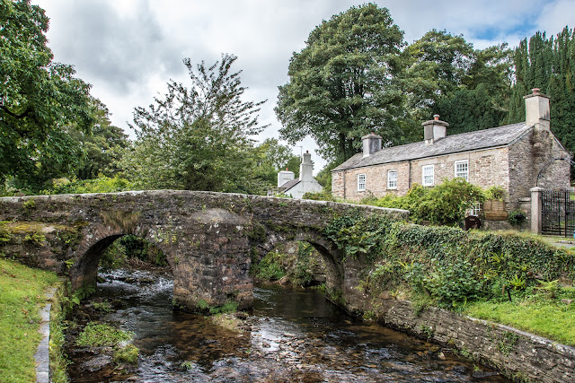
There were a few places that we had earmarked for today and the first ones were really just plucked from the map - `Picturesque village.` Well, we had to have a look at that one! The village in question, on the edge of Bodmin, was Altarnum which had this wonderful packhorse bridge, and a magnificent church, perched at the top of the village. Well worth a visit. A packhorse bridge is a bridge intended to carry pack horses (horses loaded with side bags or panniers) across a river or stream. Typically a packhorse bridge consists of one or more narrow (one horse wide) masonry arches, and has low parapets so as not to interfere with the horse's panniers. Multi-arched examples sometimes have triangular cutwaters that are extended upwards to form pedestrian refuges.  Packhorse bridges were often built on the trade routes (often called packhorse routes) that formed major transport arteries across Europe and Great Britain until the coming of the turnpike roads and canals

Crackington Haven

Image
On leaving Bude we drove to Crackington Haven, the nearest bay to our holiday home. Apparently, many surfers tend to prefer the less popular beach of Crackington Haven and yes, they were there as well. And, no, I didn't get a photo! Not a surfer, but Rosey checking her camera! In the background is Cornwall's highest cliff at 735 feet. There is Geocache at the top but my legs went weak at the thought! More rock pools and colourful rock patterns.  Some more history: 'Crackington' is a hybrid of Cornish and English 'Crack' means sandstone in Cornish and 'mutha tun' means river mouth farm in English. Located on part of the 600 mile South West Coast Path, Crackington is situated at the mouth of the picturesque valley which leads to Mineshop. It is of great geological importance with its carvoniferous rocks, which has even been given the name 'the Crackington Formation', for this reason the area has been designated a Site of