Showing posts with label Maclean. Show all posts

Friday, 13 June 2014

Our arrival in Mull

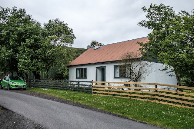
This was a holiday we had looked forward to for a long time, having spoken several times of visiting the isles of Scotland. So here we were about to spend a week on Mull. Having spent the night in an hotel on the banks of Lock Lomond, we set of today for the Oban ferry.
We sailed from Oban (above) on the mainland to Craignure on our Mull adventure. The weather looking rather gloomy and misty but the 45 min. passed quickly before we arrived in Craignure in like style - misty and murky!


After a short drive, we arrived at our holiday destination, Ardura Cottage. We were just a short drive south of Craignure, with rolling hills behind us, and set for the week. Only a few mosquitoes in sight - thankfully!


Next morning , more of the same mist, but not downhearted, we set off for ...


You guessed - Tobermory!


On the way we had to stop and photograph these old hulks of fishing vessels.


And arrived in the now famous town with it`s wonderfully coloured waterfront houses. Despite the unhelpful dull weather, it still looked as I had envisioned it. 

Tobermory owes its origins to the British Fisheries Society and their search for likely sites for fishing communities in western Scotland in the 1700s. The Society's agent, John Knox, visited Mull in 1786 and proposed making use of the superb natural harbour for such a community. The name comes from the Gaelic tobar-mhoire which translates as "Mary's Well", after an ancient holy well dedicated to the Virgin Mary in what is now the upper part of the village. 
Today Tobermory, the undisputed island capital of Mull, has a population of just over 1,000 people. These days it is perhaps best known for its connections with children's TV. First it had a Womble named after it, while a little more recently it was used as the setting for the BBC children's series Balamory. 
This turned Tobermory into a place of pilgrimage for many young fans and their parents. Although filming stopped in 2005, the appearance of the series on DVD means it still pays to book your accommodation and ferry tickets ahead if you intend to visit. 
Tobermory wraps around the bay that led to its construction. It faces south east into the Sound of Mull, and is additionally protected by Calve Island which half encloses the bay. Main Street hugs the harbour, with additional development on the hillside behind. 
Tobermory's most distinctive feature lies in the brightly painted frontages of many of its buildings. The pink, yellow and blue run of the three buildings centered on the Mishnish Hotel near the south east end of the harbour was for many years the most striking segment. In 2006 the palette changed, with the Mishnish being painted a more traditional black and its previously bright pink neighbour being toned down. The Mishnish Hotel has been returned to its earlier yellow since our most recent visit, and Tobermory has returned to being the brightest and one of the most attractive harboursides in Scotland. 


Rusty chains on the waterfront


The ever present gull watches over proceedings, no doubt anticipating some lunch.


I just loved the patterns of these 


Later in the day, when we were back at our cottage, we decided to have a stroll along the nearby lanes. The butterfly above took our attention and a reasonable image taken. It is in fact a Small Argent & Sable (Epirrhoe tristate)


This was the beautiful scene behind our cottage as the sunlight slid across the hills.


We were later treated to a display, as a local farmer rounded up his sheep in the field opposite the cottage.


Next morning we set off to explore, and headed for Carsaig, having enjoyed views over Loch Scridain on the way, before turning at Pennyghael, for our destination. 
And then onto Carsaig Bay a cove on the Ross of Mull in the south of the island of Mull. It is situated along a "narrow unclassified road". The bay is small and is surrounded by high, precipitous hills - the approach was so steep that Rosey preferred to walk down while I brought the car! It is unsafe for water craft, except in the part sheltered by the island of Gamhnach Mhòr, where small vessels can obtain anchorage.


Unsure sheep on the way!


Masses of sea weed on side of Loch Scridain


The reader - seen in a remote corner of Carsaig bay, taking in the peace and quiet - until we arrived. There are some interesting rock features nearby, but the very rough terrain and high tide made walking to them, out of the question. Anyway, a great place for lunch.


The Maclean coat of arms on a run down and isolated building near Carsaig.

Clan MacLean is a Highland Scottish clan. They are one of the oldest clans in the Highlands and owned large tracts of land in Argyll as well as the Inner Hebrides. Many early MacLeans became famous for their honour, strength and courage in battle. They were involved in clan skirmishes with the Mackinnons, Camerons, MacDonalds and Campbells, as well as all of the Jacobite risings.
Although the usual fanciful pedigrees locates the clan originally 150 miles north east at Glen Urquhart in Moray, the Macleans are from the west coast island of Mull. 
I was pleased to find this old coat of arms in this deserted spot.


Boat reflections - Carsaig Bay 


A bridge near Pennyghael, visited on the way back home.


And last for the day - a view along Glen More


Home

Saturday, 13 October 2007

Brooms Head, Yamba and Maclean

Then the morning dawned and we moved on from our cozy campsite today to go to Brooms Head. We had a good journey and arrived at the head for lunch.


A brief visit to Coffs Harbour butterfly farm in passing. 


We realised once we arrived that we had actually stayed here when we came three years ago. 


After lunch we walked to the view point where we saw several sightings of whales and also a pod of dolphins. 


Spotted this little fellow on our walk 


The Australian pied oystercatcher 


We continued to walk along the next bay but turned back as a storm was blowing up. We got back to the van just in time, however it didn't last long 


Before the sun set we walked along the beach in the other direction, and were treated to a lovely beach sunset. 


Two shoes. 

It is lovely here, but we must move on tomorrow as time is running out and we must start making our way back to the Blue Mountains on Monday. It will take us four days. 
So today, Saturday 13th October, we drove to Maclean There is something gently amusing about a town that proudly claims that it is "The Scottish Town in Australia." Of course it looks nothing like a Scottish town. The claim is based on two simple facts: a large number of the early settlers in the valley were originally from Scotland and the town itself, although the spelling has changed, was named after a good Scot, Alexander Grant McLean, who was the New South Wales Surveyor-General from 1861-1862 


I came across this amusing quote: 

One of the town's most distinctive, and overtly Scottish, symbols are the numerous Scottish tartans which have been painted on the base of the telegraph poles. Visitors who are interested can drive around town identifying a wide range of clan tartans which, conveniently, have all be named. There are now over 200 poles around the town and if you are looking for your family name's telegraph pole (a rather eccentric thing to do - "oh look! that's out telegraph pole") there is a map which is available from the Scottish Corner Shop in River Street. 


The Mathieson tartan on the levee in the park beside the Clarence River. The levee was built to protect the area as the Clarence floods. (See here for a report on the 2013 floods) 

After a wander around and picking up some groceries, we then drove on to our next camp site at Yamba. In 1799 Matthew Flinders landed on the present southern headland at Yamba. He’d been despatched from Sydney to find a new Eden, but from his vantage point atop a craggy promontory, now Pilot Head, he dismissed the turbulent estuary as dangerous and unworthy of further examination, before sailing away. In the 1830s, timber harvesting commenced. in 1861, the Townsite was surveyed, and by October 1862 construction of the breakwater Clarence River Heads Post Office was completed. Originally named Shoal Bay and later in 1885, to be renamed Yamba with a population of approx 340. 


We were at a Big 4 site and it was one of the best. There was hardly anyone on the site. It was here that the guy who ran it, offered me a job! And he was serious! 


We had the whole of the pool to ourselves in the afternoon and that included the Jacuzzi. We drove into Yambi town that evening with the intention of eating out, but we weren't very impressed with what was on offer, so we bought a bottle of wine and had dinner on site. 


There were kangaroos at the back of the site and birds everywhere. 


Sea Eagle swooping over the Clarence 


The lone camper was fishing. 


and his home I assumed? 


The crested pigeon is sometimes referred to as a topknot pigeon. This one seen outside our van. 


Seen on this site (and in several places on our trip) Paperbark tree, belonging to the genus Melaleuca, in the myrtle family(Myrtaceae), characterized by their whitish papery bark. They are native to Australia and nearby islands. I was fascinated by the way the bark peeled and the patterns it made. 


So, in the morning a visit to the edge of the site to see the many kangaroo getting their breakfast. 


Cane (Sugar) field have been part of this are in NSW for around 100 years. This field, just outside Yamba Campsite, was in the process of being harvested. 

So, another stunning site. Were we just lucky? I don`t know, as every site we have visited has been much the same. 


Home or Next


Featured post for the week

Bridges and butterflies in Pipers Vale, Ipswich

Ipswich is blessed with a number of park areas, including the great Christchurch Park. The Park we visited today is called Piper`s Vale, and...