Posts

Showing posts from June, 2023

Exmoor - Watchet and Clifton Suspension bridge

Image
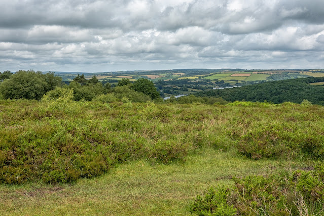
Our last day and the start of our drive home, I have included together. We decided to visit Haddon Hill on our last day on Exmoor. As one of the higher points in the southwest of Exmoor National Park, overlooking Wimbleball Reservoir. Haddon Hill provides an accessible way to experience Exmoor's wide-open moorlands. It is a wonderful place to see the herd of free roaming Exmoor Ponies that live here. The heather and gorse provide a habitat for many species of insect and during the summer, including the rare heath fritillary. With the possibility of seeing this particular butterfly, this was our first stop. We set out on the most obvious trail, and yes, there were the ponies - which kindly moved out of the way! Apart from that, the walk was somewhat of a disappointment, for the heather and gorse - not a flower in sight and obviously not a butterfly either. A pleasant walk looking across the moorland down toward the reservoir but otherwise not what we had hoped for. As there was no p

Exmoor - Valley of the Rocks

Image
Today we are off to the Lynton and Lynmouth area, to The Valley of the Rocks to be precise. The Valley of Rocks is a Site of Special Scientific Interest and a Site of Special Geological Interest and a `must see` as a tourist. But before I show some images of the area, I would mention that our route took us along the A39 and up Porlock Hill. Wikipedia sums it up: Porlock Hill is a road west of Porlock, Somerset. It is part of the A39, connecting Porlock to Lynmouth and Barnstaple in Devon and is the steepest A-road in the United Kingdom, approaching 1 in 4 (25%) in places. A parallel toll road is available which travels the same route at an easier gradient. - If only I had known! Never mind, it was an experience! We stopped at this point, firstly in relief and secondly to admire the fantastic view! It was called Foreland Point and was a wonderful place to admire the view and watch the mist rolling across the hills. Foreland Point We had parked the car a short distance from the Valley

Exmoor - Cleeve Abbey & Crowcombe Church

Image
Cleeve Abbey in Somerset housed a community of Cistercian monks for almost 350 years. At its peak it was home to 28 monks. Between 1186 and 1191 William de Roumare, Earl of Lincoln, gave all his lands at Cleeve for the foundation of a Cistercian abbey. The first abbot and his monks arrived in 1198 from Revesby Abbey in Lincolnshire, which had itself been founded by William’s grandfather. Cleeve was originally called ‘Vallis Florida’ (valley of flowers) and it soon attracted further gifts, mainly of land, from other local aristocrats. When William founded the abbey, it was partly out of religious belief and partly out of self-interest. Founding an abbey was expensive, but medieval people believed that many prayers were needed to avoid a long stay in purgatory, or worse still descent into hell. It was thought that the best people to pray were the men and women – monks and nuns – who led a perfect Christian life dedicated to God. After the abbey’s suppression in 1536 the church was destro

Exmoor - Minehead

Image
The small port town of Minehead was our destination for today. I have heard of the town in many ways over the years but have never been here. It's a pretty port area with the usual array of small boats which makes a picture! First image is looking toward the quay area Looking right from the same vantage point and you can just see (at the top of the image) the marquee of Butlins Holiday Complex. So, it was decided to walk to the quay area On the way we passed this sculpture to indicate that we were indeed on the West Somerset Coastal Path. Also, along the promenade, we came across several of these colourful characters indicating the premises nearby. There were some really clever ones I thought.  I rather liked this one outside a cafe for example. Approaching the quay with its boats  The tide was going out leaving patterns in the sand Many lovely buildings are spread along the promonade Back at the area where we had parked and started our walk, this clock stood in a square with sever

Exmoor - Tarr Steps and Dunster

Image
The Tarr Steps is a clapper bridge across the River Barle in the Exmoor National Park. The stone slabs weigh up to two tons each. The bridge is 180 feet (55 m) long and has 17 spans. It has been designated as a Grade I listed building and scheduled monument. It is an ancient form of bridge constructed with large unmortared slabs of stone resting on one another; this is the largest example of its type and is one of the best-known monuments on Exmoor. Its age is unknown, as several theories claim that Tarr Steps dates from the Bronze Age, but others date them from around 1400 AD. It has been restored several times in recent years, following flood damage. Tarr Steps The area around here is beautiful, and the riverside walk was an obvious attraction! It didn't disappoint as it was peaceful and unspoilt. View of the River Barle as we crossed a bridge to continue our walk back on the other side of the river. The wire bridge which captures most floating debris in the event of a storm As