Showing posts with label Geocaching. Show all posts

Wednesday, 1 June 2016

A `Church Micro` cache at Aldham church

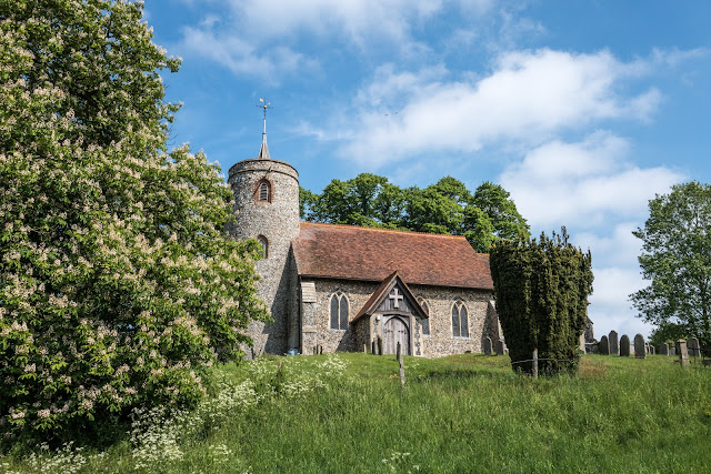
Aldham is a short distance from Hadleigh, being just on the opposite side of the bypass.
There are a series of Geocaches called Church Micros, as they are (reasonable obviously) placed near to Churches. They are never actually on Church property, but, as in this case, they often depend on you gleaning information from the Church and its grounds, to enable you to work out the final position of the cache. This allows you to explore some wonderful historic building in the process, and learn some interesting things as well. Three clues had to be obtained in this case, and duly pointed me to a spot a short distance from the church, where the cache was soon to hand!


One of the clues which helped find the final cache, was information on this sundial in the churchyard. So, some picture of this lovely country church of St Mary with it`s round tower.
The church itself is a flint church with stone dressings built circa 1340. A circular west tower has a 11c-12c base, which appears to be the oldest part. The chancel has a 14c kingpost roof and there are some 15c carved benches and lectern.


This church was derelict by the mid 19th century, and underwent a fairly late restoration, in 1883. The tower was rebuilt, as was the south wall of the nave. The roofs were replaced, giving an overwhelmingly Victorian appearance. There was another restoration of the inside in the early 20th century.


The setting of the church is beautiful and tranquil, and worth a visit just for the views.


The Three Tuns was situated at 106 High Street. This pub closed in 1911 and is now in residential use. It used to brew its own beer; the well used for this still remains and is under a covenant on the house that it cannot be altered. I took this photo in the morning having walked past this building many times but not noticed the sign. However, I love the sign, shame I missed the top of the image!


Home    Forward   Back

Wednesday, 20 November 2013

Dalby Forest and the Bride Stones

Not too far from Pickering is Dalby Forest and the Bride Stones. Today this was our destination, a walk in the forest. It is on the southern slopes of the North Yorkshire National Park. It was a glorious day - we have been so lucky at it is November!


A memorial to the "lumberjills" - the women who worked in forestry during World War Two


As we entered the forest we saw this sculpture, so we had to investigate! Later, a little investigation revealed its origins:
The sculpture is a steel fabrication of a felled tree and two lumberjills. Some 9,000 British women were recruited to work in forestry during the war. 
The lumberjills carried out heavy work, felling trees by hand, working in sawmills, loading trucks and driving tractors.
The timber was made into telegraph poles, road blocks, packaging boxes and gun butts for the war effort, and even crosses for war graves.
Sculptor Ray Lonsdale won the Forestry Commission competition to create a lasting memorial to honour the women.
The sculpture on Haygate Bank in Dalby, called Pull Don't Push, is five metres long and three metres high. The Forestry Commission said the sculpture "captures the arduous nature of the work as well as the fun lumberjills had working in the forests during the war."


As it was November, the forest was full of late autumn colours.Leaves in many shades and of course the forest floor of bracken.


The Bridestones. 


Aptly named ‘Brink-stones’ or edge stones in Old Norse, you can follow footpaths to the top to experience the Bridestones first hand. These fascinating rocks are the remains of a sandstone ‘cap’ that was originally much higher, Jurassic sedimentary rock deposited some 150 million years ago.
Layers of hard sandstone alternating with softer calcareous layers have been eroded by wind, frost and rain over thousands of years. The result is the strange and wonderful shapes left today. 


What is this? Well, one of my interests, especially when in new places, is Geocaching. If you are unfamiliar with the term, follow this link
In this area was a cache I was trying to find, and realised from the clue that it was probable disguised. Suddenly, on a pile of logs I spotted a log with a screw in the end. On investigating, the top of the log rotated on the screw revealing the log book. Very crafty! 


The surrounding nature reserve is a high, wild and inspiring blend of open heather, rough pasture, wooded hillsides and stunning summer-flower filled grassy dales. It is a designated Site of Special Scientific Interest (SSSI), so sensitive management is very important. On the open moor new tree growth is controlled and you might see cattle which are grazed to stop the land returning to the woodland it once was.
Bridestones Griff separates the two groups of stones, leading to the grassy valley of Dovedale and its ancient woodland. It’s the perfect place to enjoy wildflowers, butterflies and birds at the edge of a rippling beck, although when we visited it was just autumn colours.


The view from Sutton Bank on the way home to our holiday cottage.

Sutton Bank is a hill in the Hambleton District of the North York Moors National Park, North Yorkshire in England. It is a high point on the Hambleton Hills with extensive views over the Vale of York and the Vale of Mowbray.
At the foot of Sutton Bank lies the village of Sutton-under-Whitestonecliffe; at 27 letters long, it has the longest hyphenated placename in England.
The A170 road runs down the bank with a maximum gradient of 1 in 4 (25%), and including a hairpin bend. Vehicles have to keep in low gear whilst travelling up or down the bank, and caravans are banned from using the section. 
After our first ascent, we relaxed on subsequent trips to the top! We walked from the Sutton Bank National Park Centre at the top to a point where we could watch the gliders taking off from the Yorkshire Gliding Club.


Another view from the top of Sutton Bank


Green phone box - Fangdale Beck, North Yorkshire.The unusual colour was by special agreement with the local landowner. 
Apparently a story circulating has this info: "It was my late father, Fred Jackson, who was responsible for the green phone box. He worked at the then Telephone Managers Office in Middlesbrough as a sales executive and was responsible for most of the selling of phones to the Dales farmers of the area during the late 1940's and early 50's. 
He hated the thought of a red kiosk in such a stunning area and worked very hard - obviously with the local landowner, to achieve the green box."
Is it true? - who knows!, but it was worth seeing.


Next morning was time to head home and we were greeted by this glorious sunrise for our last morning.

Home    Forward     Back

Featured post for the week

Bridges and butterflies in Pipers Vale, Ipswich

Ipswich is blessed with a number of park areas, including the great Christchurch Park. The Park we visited today is called Piper`s Vale, and...