Showing posts with label Tower. Show all posts

Sunday, 4 May 2025

Extreme Abseil at Ipswich Hospital's Tower

To quote the web site of  Colchester & Ipswich Hospitals Charity

We are proud to be the official NHS charity of East Suffolk and North Essex NHS Foundation Trust, which provides hospital and community health services to around one million people and in 2022/23 was the second largest NHS organisation in the region.
When you make a donation to the Colchester & Ipswich Hospitals Charity, you help take care of patients and staff at your local hospitals and healthcare centres – providing those extras that go above and beyond what the NHS can provide, and which make such a difference to happiness and healing.
You’ll help improve patients’ lives by bringing some good into a difficult time, such as making sure there’s tea and coffee in the waiting room for patients receiving chemotherapy or providing the slippers that keep older patients safe from falls.
Your kindness can also help provide the hospitals with the life-saving equipment, cutting-edge technology, research and innovation that can transform the healthcare available to your friends and family, when they need it most.

This Charity is very important as our Grandaughter has been in the care of Ipswich Hospital, amongst others, since her brain tumour was removed five years ago. Her father, our son, was raising money for them by doing this extreme abseil. In his words:

I've decided to be really brave and take on Ipswich Hospital's Tower by abseiling down it!
It's 135 feet high, but every foot will count towards fundraising for Colchester & Ipswich Hospitals Charity. They are the official NHS charity of East Suffolk and North Essex NHS Foundation Trust.
I'm raising money for the children’s play team. They do amazing work with children in the hospital going through treatments and helping to deal with the ongoing psychological effects post treatment.
The team have, and continue, to provide invaluable support for Em following her cancer diagnosis and treatment in 2020. We will always be grateful for their support.

So onto the photos!


Well done Matthew. That`s £700 plus raised!


Friday, 17 August 2018

Izobelle in Walton on the Naze

A day at the coast seemed a good idea during the school holidays, and as Felixstowe is the regular seaside, what about Walton on the Naze, by the Tower and with less people generally? Having decided that was a good idea, buckets and spades were packed (for me) and some for Izobelle.


This looks like a good spot, and very quiet too. Amazing how much the cliffs have eroded since our last visit.


A fort was soon under construction, and some finishing touches given to this section .


During these constructions, the right sized stones have to be used so a working party was organised to hunt for them (Nana).


Having put in all that work, a photograph has to be taken for posterity of course.


When we had had enough on the beach, we climbed back to the top of the cliff, and to the Tower for a coffee and cake. Izobelle and I decided that a climb to the top was in order. I was amazed at her lack of fear in climbing the very steep stairs.
Once at the top we were treated to great views and so descended, very pleased with ourselves. All in all, a very enjoyable day was had by all.

The present tower was built in 1720–21 by Trinity House, and was intended to work in conjunction with Walton Hall Tower to guide vessels through the Goldmer Gap. Towers at Naze and at Walton Hall are marked on a map of 1673 by Richard Blome, which in turn was based on a map drawn up in the late 1500s. 
The present Naze Tower therefore replaced an earlier construction at a similar location. It was of particular benefit to ships using the nearby port of Harwich. Both the current Naze Tower and its predecessor had beacons or lamps lit at the top, providing an early form of lighthouse.
Over the years, the tower has had a variety of uses. In the eighteenth century it was a tea house, operated by the actress and aristocrats' mistress, Martha Reay. It was a lookout during the Napoleonic Wars and again during the Great War of 1914–18. In the Second World War it was used as a radar station, with its crenellations removed to accommodate a radar dish.
Naze Tower was given Grade II* listed status in 1984 by English Heritage. Since 1986, it has been in private ownership.
Well worth a look if you are nearby. 


Tuesday, 10 October 2017

Raglan castle - built to impress

Tuesday dawned rather dull and it was difficult to guess what the weather would do. However as the sun began to peep through, we headed out to Raglan Castle. First impressions were spot on - the place is huge! 
It is a magnificent Tudor-period sandstone structure, which was not built specifically as a defence as the other great castles of Wales had been. Instead, it was designed mainly as a statement of wealth and influence. 
A manor had existed on the site before William ap Thomas acquired the property through marriage in 1406. A veteran of Agincourt in 1415, ap Thomas enjoyed the favour of King Henry VI and was knighted in 1426. He wanted to demonstrate his upwardly-mobile status, so set out on an ambitious building plan for Raglan. In 1435 he began work on the Great Tower, also known as the Yellow Tower of Gwent, but he was never to see it completed, as ap Thomas died in 1445. The building work was continued by his son, William, who took the surname Herbert. 
Herbert continued his father's building work, drawing on continental influences common to veterans of the French wars. The building was complex and stylish - and the polygonal structures used can still be seen today. Herbert supported the Yorkist cause in the Wars of the Roses, and was made Lord Herbert of Raglan by King Edward IV in 1461, then Earl of Pembroke. His rising fortunes were reflected in Raglan Castle as more sumptuous building works were added. When Herbert was defeated at the battle of Edgecote in 1469, he was beheaded and the castle went between families during the Tudor period depending on the ruling families factions and fortunes. 


The main problem we faced was that the rain was beginning to fall. However, between showers, we took a few photos and did some exploring, but as the rain persisted, we headed for the tea room and an early lunch.


The dominant structure is the Great Tower, seen here on the left. Raglan Castle is one of the last true castles to be built in Wales. Its construction began in the 1430s by Sir William ap Thomas, the Blue Knight of Gwent who fought at the Battle of Agincourt with King Henry V in 1415. He was responsible for building the Great Tower at Raglan, which became known as the Yellow Tower of Gwent.


During the showers we were treated to a rainbow over the castle!

During the English Civil War in 1646, Raglan Castle was besieged by parliamentarian forces led by Sir Thomas Fairfax. The castle was surrounded and mortar batteries (short bell shaped cannons) were dug into place. Henry Somerset who attempted to defend the castle, knew his efforts were futile and surrendered to Fairfax. As a result of the siege, the castle was heavily damaged and thus began a period of disrepair


Another view of The Great Tower at Raglan, which in its finished state was another storey higher.


The magnificent Gatehouse to Raglan Castle, with the Closet Tower to the right. Note the beautiful carved and jointed work on the tops - this really was a statement of wealth in reality!.


A closer look at the tops of the towers.


A Corbel from the Chapel roof in Raglan castle. In architecture a corbel is a structural piece of stone, wood or metal jutting from a wall to carry a superincumbent weight, a type of bracket. A corbel is a solid piece of material in the wall, and there would, I guess, have been several of them supporting the ceiling or the floor above.


Carving which have survived in the Long Gallery.


Arrowloop at Raglan Castle


Detail of the windows badges and shields above the State Apartments - the Lord's Bedchamber.
The castle was also the boyhood home of Henry Tudor, later King Henry VII. As a boy he spent his time at Raglan, while his uncle Jasper agitated a Lancastrian return to the throne in the person of young Henry - so history tells us.
A great day out with plenty to soak up. (Pun intended!)  Well worth a visit.


Home    Forward     Back


Sunday, 2 February 2014

What can be seen at Walton on the Naze?

Walton is a traditional seaside town on the east coast, unique in that it is surrounded on three sides by the sea. Its three miles of gently shelving sandy beaches facing south-east stretch from Frinton to the Naze. To the north, the sea sweeps round the Naze into the backwaters, known as Hamford Water, and the Walton Channel stretches right down to Walton Mere, only 300 yards from the main beach. The Naze, as well as being a natural open space, is a Site of Special Scientific Interest (SSSI) famed for its fossils found in the Red Crag cliffs.
As well as these glorious natural features, Walton is known for its pier – the second-longest in the country – its yacht club and marina, and its iconic tower at The Naze from where panoramic views can be enjoyed of the Walton backwaters, Harwich and Felixstowe and the Suffolk coast. 


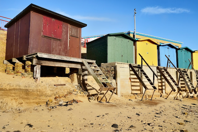
The coast of East Anglia is always subject to erosion and the day of our visit to Walton demonstrated the effects which a stormy period on the North sea can have on the area 
These beach huts would normally have a bit more sand in front, but it has been washed away leaving a nasty gap between bottom step and the beach! 


Another view of an area normally deep in sand. 


One has to wonder haw many years before the famous tower is in danger? Built in 1720 by Trinity House as a navigational aid for ships making for Harwich Harbour – is now an art gallery and tea rooms 


More of the cliff has slid toward the sea


Somehow, there is always an odd shoe.


.... or a glove! 


So to some wildlife. In a row - shame about the empty end posts! 


Sanderling seen on the beach 


What are you doing down there? 


Three is a crowd. 


These swirls are the “castings” of a worm. Various species of lugworms are found in sandy marine mud all over the world. They ingest the sandy mud at one end, and excrete digested sand at the other. They can process a cubic centimeter or more of sand every hour. The worms digest the bacteria and other microorganism in the sand, in much the same way that earthworms process soil. So, some images of worm poo! 


Patterns in the sand 


The colour green. Seaweed coating the steps to the beach.


Under the pier. A view toward the sea as the tide retreats


Colours


Gulls inviting themselves to lunch 


The remains of a WW2 pillbox on the beach. The Walton of today is a somewhat different place to that of WW2 due to it`s proximity to the entrance to Harwich . A good taster of how the area was in that period can be found here.


Monday, 14 February 2011

What we saw in Walton

One of our favourite seasides is Walton On The Naze, and it was to Walton, as is generally known, that we decided to spend the day. It's surprising what you can see when you are not in a hurry, and having a camera and photographs in mind. A good starting point is at the landmark point of the Naze Tower. 
The Hanoverian tower, more commonly known as the Naze Tower, is situated at the start of the open area of the Naze. It was a navigational tower, constructed to assist ships on this otherwise fairly feature-less coast. Visitors can climb the 111-step spiral staircase to the top of the 86-foot (26 m) tower for a 360 degree view of the beach and countryside. The Naze Tower features a museum with exhibits about the tower, the ecology and geology of the Naze, and the coastal erosion problem. The tower also features a private art gallery on six floors with changing exhibits several times a year, and a tea room. 


The present tower was built in 1720–21 by Trinity House, and was intended to work in conjunction with Walton Hall Tower to guide vessels through the Goldmer Gap. Towers at Naze and at Walton Hall are marked on a map of 1673 by Richard Blome, which in turn was based on a map drawn up in the late 1500s. The present Naze Tower therefore replaced an earlier construction at a similar location. It was of particular benefit to ships using the nearby port of Harwich. Both the current Naze Tower and its predecessor had beacons or lamps lit at the top, providing an early form of lighthouse. 
Over the years, the tower has had a variety of uses. In the eighteenth century it was a tea house, operated by the actress and aristocrats' mistress, Martha Reay. It was a lookout during the Napoleonic Wars and again during the Great War of 1914–18. In the Second World War it was used as a radar station, with its crenellations removed to accommodate a radar dish. 


Another view of the tower, this time from the beach below the cliffs. It's beginning to look rather precarious, however, looks are deceptive as it is someway back from the edge still.


As these later images show, the Walton cliffs are eroding at an alarming rate - as is a lot of the Suffolk and Norfolk coast line.


Walking back toward the town, I noticed this dog peering down at us. I did think he would scramble down at one point but it didn`t.


Not sure what the man was doing, if anything, but the gulls were very active overhead.


Green symmetry.


How a long focus lens alters the perspective. They are close, but not quite as the image would suggest.


More symmetry or repetition.


Gulls swooping around this couple enjoying their lunch


Five in a row - and all facing the same way!


Yet more symmetry under the pier - watch the tide!