Showing posts with label sundial. Show all posts

Wednesday, 24 June 2015

The Giant Man and Sherborne

At the start of our explore of Cerne Abbas, we walked along the top of the ridge known as Giant Hill or Trendle Hill. The scenery was beautiful and the flowers added to a very pleasant morning walk


The Cerne Abbas Giant is located just outside the small village of Cerne Abbas in Dorset, about 48 kilometres (30 mi) west of Bournemouth and 26 kilometres (16 mi) north of Weymouth. The figure depicts a huge naked man, about 55 metres (180 ft) high and 51 metres (167 ft) wide. It is carved into the white chalk rock on the steep west-facing side of a hill known as Giant Hill or Trendle Hill. 
The carving is formed by outlines cut into the turf about 0.6 metres (2 ft 0 in) deep, and filled with crushed chalk. In his right hand the giant holds a knobbled club 37 metres (121 ft) in length, and adding 11 metres (36 ft) to the total height of the figure. A line across the waist is considered to be a belt. 
A 1996 study found that some features have changed over time, concluding that the figure originally held a cloak in its left arm and stood over a disembodied head. The former presence of a cloak was corroborated in 2008 when a team of archaeologists using special equipment determined that part of the carving had been allowed to be obliterated. The cloak might have been a depiction of an animal skin, giving credence to the theory that the giant was a depiction of a hunter, or alternatively, Hercules with the skin of the Nemean lion over his arm. Additionally, reviewing historical depictions of the giant, it has been suggested that the Giant's current large erection is, in fact, the result of merging a circle representing his navel with a smaller penis during a re-cut. In 1993, the National Trust gave the Giant a "nose job" after years of erosion had worn it away. 
The Giant sports an erection, including its testicles, some 11 metres (36 feet) long, and nearly the length of its head. One commentator noted that postcards of the Giant were the only indecent photographs that could be sent through the English Post Office. 
Although the best view of the Giant is from the air, most tourist guides recommend a ground view from the "Giant's View" lay-by and car park off the A352 Not as good as the aerial shots but a record nonetheless.


The lone tree

Sherborne is a market town and civil parish in north west Dorset, in South West England. It is sited on the River Yeo, on the edge of the Blackmore Vale, and was made the capital of Wessex, one of the seven Saxon kingdoms of England. King Alfred's elder brothers King Ethelbert and King Ethelbald are buried in the abbey. 


The former church of Sherborne Abbey is one of the county's finest medieval buildings. The first church here was established in the 8th century as part of a Saxon abbey. Of that Saxon building little remains beyond a doorway. 
Tradition tells us that the abbey was established by St Aldhelm, who came to Sherborne in AD 705 at the invitation of his relative, King Ine. The king had divided the huge see of Winchester in two parts, and wanted Aldhelm to serve as the bishop of a new see that encompassed Dorset, Wiltshire, Somerset, Devon, and Cornwall. 
It seems very likely that Aldhelm established his new abbey on an existing place of worship, which would make the foundation of Sherborne Abbey very ancient indeed. Aldhelm came to Dorset to assert the authority of the Roman Catholic style of worship over Celtic Christianity, and it is said that 'by his preaching he completed the conquest of Wessex'. The abbey church served as the cathedral seat of 27 Saxon bishops until the bishopric was moved from Sherborne to Salisbury in 1075. Even after this the Bishops of Salisbury retained the manor of Sherborne and the 12th century castle here. 
After the see was moved to Salisbury the abbey church became the church of a Benedictine monastery. The monastery lasted until it was dissolved by Henry VIII at the Reformation, and then the monastic church became the parish church of Sherborne. 
There is nothing left of St Aldhelm's original abbey. There is surviving Saxon stonework at the west end of the present church, but this dates to a later Saxon rebuilding of Aldhelm's monastic church. The original Saxon church probably stood to the west of the present nave. During the bishopric of Bishop Alfwold (1045-1058) a new, larger church was begun to replace the earlier single-celled building. The new Saxon church consisted of a nave and choir with transepts. This forms the basis of the building we see today. The remainder of this magnificent medieval building was the work of Abbot Ramsam (1475-1504), who built the choir and rebuilt the nave and north transept. 


The Conduit is a 16th century hexagonal washing area originally used by the Monks of Sherborne Abbey. With the dissolution of the monastery in 1539 the building was moved to its current location on Cheap Street. I just managed to chop the side in this image, in my attempt to capture the other buildings! 


Midsummer, also known as St John's Day, is the period of time centered upon the summer solstice, and more specifically the northern European celebrations that accompany the actual solstice or take place on a day between June 19 and June 25 and the preceding evening. The exact dates vary between different cultures. The Christian Church designated June 24 as the feast day of the early Christian martyr St John the Baptist, and the observance of St John's Day begins the evening before, known as St John's Eve.The garland was in place when we visited St John's House (see below) 


There are many examples of the use of Midsummer garlands in the Middle Ages, as exemplified in this article.


The almshouses of saints John the Baptist and John the Evangelist, founded in 1438 and expanded in the Victorian era in indistinguishable medieval style architecture. 


Looking around these wonderful old towns you can be sure to find some lovely examples of sundial, this one being in the town of Sherborne. 


I just love window and door combinations and this one took my eye in Sherborne 


Home    Forward   Back

Sunday, 17 November 2013

Gillamoor and Lastingham - The Moors

Today was another exploring day through the village of Gillamoor and onto Lastingham. Not sure what we will see but as we have time on our hands ,and a full tank of petrol, off we go!


Gillamoor is a village and civil parish in the Ryedale district of the county of North Yorkshire. It is situated about three miles north of Kirkbymoorside on the edge of the North York Moors National Park. 
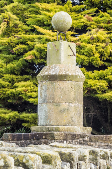
Once there, the first thing to catch our eye was this sundial. An unusual, complex, four-faced sundial (pictured above) surmounted by a finely carved stone globe, a Grade II listed structure. It stands by the roadside in the centre of Gillamoor. It was erected August 27th 1800 by John Russell by public subscription


The small attractive village church of St. Aidan stands right on the edge of a moorland escarpment, dropping sharply for 150 feet to the River Dove and the southern entrance to Farndale. It was rebuilt single-handedly in 1802 by local stonemason James Smith of Farndale using stone from the dismantled medieval church in Bransdale. The building was restored in 1880, and furnished by Temple Moore in 1908.
A church has occupied the site since as far back as the twelfth century. The present church consists of a simple rectangular structure with a nave and chancel and a porch at the western end of the south wall and an attractive bellcote at the western end of the building. The church is windowless on the north and west sides, reckoned a necessary safeguard against the prevailing winds.


View from the village toward the moors before we drove onward toward Lastingham and a brief look at the church


Simon Jenkins, author of England's Thousand Best Churches, calls the Norman crypt of St Mary's church in Lastingham 'one of England's special places'. It is certainly amazing that it has existed for so long and just standing there and thinking of the generations of people who have knelt here, it is awe inspiring!


Around AD 725 the first stone church was built on this site n 1228 the former monastic church became the parish church for Lastingham village. A north aisle was added, followed by a south aisle in the 14th century, and a west tower was added in the 15th century. The church was in poor condition by the 17th century, until it was rebuilt by Thomas Ferres, a native of Lastingham who rose to become Mayor of Hull.
One interesting footnote in the history of Lastingham church comes from the 18th century when a curate named Jeremiah Carter was employed by an absentee vicar. Carter was married, with 13 children to support, so he supplemented his family income by fishing, while his wife kept the local Blacksmith's Arms pub. 
Carter was known to play the violin to entertain visitors to the pub. When questioned by the archdeacon on the propriety of his actions, Carter replied that his parishioners enjoyed three advantages, being instructed in religion, fed and entertained all at once. He argued that this method spending the Sabbath was so agreeable that his charges were 'imperceptibly led along the paths of piety and morality...'
Interior highlights include a 12th century font, a medieval floriated grave slab, and a free-standing 15th century water stoup.
The main attraction for many people is the Norman Crypt.


And so onto Lunch which was greatly enjoyed at the Moors Inn. The Moors Inn has been trading as an inn since the 17th Century in the beautiful village of Appleton- Le Moors.


Home    Forward     Back