Posts

Showing posts from April, 2015

Stackpole Estate - my first visit

Image
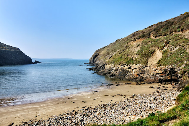
A `must visit` place in Pembrokeshire is the NT Stackpole estate which has some of the most stunning coastal views to be found anywhere. It’s difficult to imagine the many buildings that may have graced the Stackpole Court site over the centuries. Occupied since Norman times, the Stackpole Estate has seen its fair share of boom and bust over the centuries. The Campbell's built the early Georgian mansion of Stackpole Court in the Palladian style in the 1730s on the site of the earlier fortified house. Two world wars heralded a century of decline at Stackpole. Half of the estate, around 6,000 acres, was requisitioned by the Ministry of Defence to form Castlemartin Range in 1938. Sir John Campbell II inherited the estate in 1777 and began landscaping work on a grand scale. What was once a valley was later flooded to create the Bosherston Lakes, as part of a designed landscape, and thousands of trees were planted. Thirteen years later, what was left of this historic estate

A trip to Skomer

Image
Today a trip to Skomer! We boarded the 11am ferry with 15 or so other passengers for our short 10 min crossing, the sea being really calm. On the approach to Skoma we saw Puffin in large numbers flying around, or just swimming in groups on water. After a short talk by the Wardens, we were off to see what we could see toward the center of the island, photographing the trigpoint on the way and walked toward The Wick. This was the area that we saw the most puffins in their burrows – brilliant. While strolling along this area we also saw choughs flying around. We stopped and had our picnic lunch and continued before deciding to head back through the centre toward the old 19th century farm buildings and the landing stage in hope more puffin pictures Saw some on the water only, but great walk anyway. The boat very crowded on way back but it was only a short journey. All in all, a great trip and well worth doing. Trig point on Skomer marking its height above sea level at

A Geocaching day in Pembrokeshire

Image
Tuesday we decided to try and pick up a few local Geocaches and our first stop was for one at Nolton Haven, a pretty beach as usual. If you have never tried Geocaching follow this link for an explanation. As a worldwide treasure hunt, it is suitable for most ages, and is great fun - and addictive! In the 19th century this was a busy port, as coal was exported from Nolton and nearby Newgale. It was a good easy cache to find. Newgale – great surfing bay with beach berms (Piles of shingle / stones)  Maidenhall was our next stop, where a great view from the car park viewpoint and another cache awaited. Well hidden in the wall.  Then a short drive to Newgale with it`s great surfing beach and berms. Here, one earth Cache and two regular ones completed our tally before heading back to Broad Haven for a steak pie lunch – lovely! So, a berm, a dictionary definition is: A nearly horizontal plateau on the beach face or backshore, formed by the deposition of beach material by

The Marloes Peninsula

Image
The Marloes Peninsula coastal walk was our target for today.This walk starts near Marloes Sands and passes Marloes Mere, an area of wetland pools and marsh important for ducks and other wild fowl. Hen harriers and short-eared owls can often be seen quartering the marsh, not that we saw any I am afraid. After passing an impressive Iron Age fort, the route joins the Coast Path. It stays just inland from the cliff tops, but offers great views of the coast and the islands of Skokholm, Skomer and guano covered Grassholm in the distance. All three are home to important seabird colonies in the summer. The walk crosses coastal fields which are managed to encourage chough, something that we did see, and watched, for a considerable time – magic! Finally arriving at the Deer Park with spectacular views of Skoma and then onto Martin's Haven, the embarkation point for Skomer.  Islands seen from the Marlos Coastal footpath The caterpillar of the Oak Eggar (Lasiocampa que

Solva and St David`s Head

Image
Sunday saw us drive the coastal road to Solva. On the way passing Newgale and it's great surfing beach and massive pebble beach called a BERM – a term I had never come across before. We will return to have a closer look another day. Then a return visit to the lovely sheltered harbour of Solva where we went for short 2 mile walk followed by a hearty lunch at the Ship pub. After lunch, on through St Davids to Whitesands beach and a walk around St David’ Head. Stunning beach and walk – very weary on finishing as the ground was quite rough, but well pleased with ourselves.. Looks cosy to me! as snails crowd into a crack of a tree. Gorgeous coloured leaves emerging on the coastal path. Lime kilns on Solva beach Limestone would have been brought in by boat and heated in these kilns to produce the lime mortars that Newport’s stone built houses would have been constructed with, they would also have been lime washed (a quicklime and water mix) on a regular basis

Arrival in Broad Haven

Image
We found the cottage, which is a part of a converted farm building, in a gloriously quiet area, just up from Little Haven. We are opposite the owners farmhouse, and it's idyllic! Our holiday cottage in Broad Haven ... and part of the garden, leading to some woods. One wind bent tree seen one late afternoon in the woods near our cottage  Looking across Broad Haven beach from the war memorial.  Saturday, our first full day, we took a walk from Broad Haven, near to where we were staying, to Little Haven – along the coastal path and back by the beach. Followed up with a really good fish & chip lunch. After lunch, a short drive north of Broad Haven beach and a walk back along the coastal path. Three Geocaches found for the day, including one Earth Cache. Not bad.  Broad Haven beach with ripples left by the retreating tide.  One of several caverns cut into the cliffs along this coast – this one was called the Foxhole I think