Saturday, 19 May 2018

The first weekend of our Kent holiday

Kent Was our destination for the week, a converted dairy on the nearest farm to France! (So the war time history said) It was in fact in Reach Court farm in the village of St Margarets-at-Cliffe, Dover. Within a few minutes walk of the famous white cliffs.
Having had a good journey, only 130 miles, we settled into our cottage and took ourselves on an exploration of the area, by foot of course. 


This was our home for the week. You can just see our red door on the right. 
This area around Dover has a large amount of history associated with the second world war in particular, but being close to France, previous invasion attempts as well. We passed numerous reminders of this history on our way to the cliff top/ walk, in the form of posts and notices reminding us of the legacy of the great conflict. 
We arrived at the cliff edge and were treated to spectacular views of the coast line including the entrance to Dover harbour, just along the coast. 


Part way along the walk we came to South Foreland Lighthouse. As a national Trust property we had free access, today being an open day - lucky us! Our guide was very knowledgeable and passed on a lot of information, not only of this lighthouse, but an insight into the life of lighthouse men in general through the ages.


This particular lighthouse was the first one anywhere in the world to use electricity to power its light. Prior to this, it had gone from a fire on the top of a tower (1635 possible), to oil fired lamps (1793) using whale oil, and onto using a similar oil as Rapeseed oil. The first electric light was simply a spark jumping between two carbon rods before moving onto the primitive early bulbs in the early 20th century. The electricity was first generated by a steam generator which had to be specially built. This was in the days before mains electricity.
The need for a lighthouse here is mainly due to the Goodwin Sands, notorious for its many shipwrecks.
Sunday dawned very dull so we did not travel very far before lunch. We booked sunday lunch in the village at the White Cliffs pub and it was a great roast beef lunch. Then we headed a short distance along the coast to Deal to see if I could get a hot water bottle, as I was very cold last night! No joy, but by this time the misty cloud was beginning to lift so we headed back to St Margarets Bay to take a few images and see if a walk along the cliff top would produce any butterflies. Rosey managed to find one that she had not photographed before, which was worth the walk. 


Some properties were a bit more humble!


Some a bit more elegant 


Some of the properties built along this cliff are amazing, and the view! - well amazing in all weathers, I would expect.


We ended our walk here, by the Dover Patrol Monument. The Dover Patrol Monument is a war memorial designed by Sir Aston Webb to commemorate the Royal Navy's Dover Patrol of the First World War. Two identical granite memorial obelisks, 75 feet (23 m) high, were erected near Dover and Calais in 1921 and 1922. A third was erected in Brooklyn, New York, in 1931. The UK monument became a Grade II listed building in August 1966, promoted to Grade II* in August 2015.
The Dover Patrol was formed in July 1914, around a nucleus of the 12 Tribal class destroyers. Through the First World War, a variety of craft served in the patrol—cruisers, destroyers old and new, submarines, mine-sweepers, armed trawlers and drifters, armed yachts, motor launches and other coastal craft—as well as a variety of aircraft - flying boats, aeroplanes, and airships. From time to time, French destroyers were included in the patrol.
he patrol covered the southern part of the North Sea and the eastern portion of the English Channel, including the Straits of Dover. Its duties included escorting merchant ships, hospital ships and troop transports; anti-submarine patrols; sweeping for German mines, and laying British minefields and anti-submarine nets; and bombarding German land forces on the coast of Belgium and northern France. It was commanded by Admiral Reginald Bacon from 1914 until his retirement at the end of 1917, and then by Vice-Admiral Roger Keyes. Six members of the patrol were awarded the Victoria Cross in a single action on 22–23 April 1918, for their part in the Zeebrugge Raid to block the entrance to the port of Bruges-Zeebrugge and so prevent German vessels from leaving port.
Some 2,000 members of the patrol lost their lives during the war. A committee was formed in November 1918 to raise a public subscription for the erection of a monument in memory of the patrol. Over £45,000 was raised, including £1,000 donated by King Albert and Queen Elizabeth of the Belgians


Saturday, 21 April 2018

Suffolk Wildlife Trust`s Fox Fritillary Meadow

Fox Fritillary Meadow is an ancient floodplain. It is the largest of four remaining sites for the snake's head fritillary in Suffolk, and it was to here that we booked to visit to see these beautiful wild flowers. Visiting Fox Fritillary Meadow is by prior arrangement only, and visitor numbers are restricted, so we booked some 2 months back for this year.

According to Suffolk Wildlife Trust:- The Snake's-head fritillary is a most unusual looking wildflower and the UK's only native fritillary species. When in bloom in spring, this flamboyant wildflower is unmistakable. Its nodding purple and sometimes white flowers have distinctive chequer-board markings resembling a snake’s skin. Before it flowers its presence may be overlooked as the foliage is grass-like, but once in flower it is a spectacular sight, forming a wonderful purple haze across the meadow. The number of local names, including Snake's-head lily, Crowcup, Leper's Bells and Chequered Lily, suggest that this was once a common countryside sight


Its first recorded presence in the wild in England was in 1736 and its origin has been debated by botanists ever since. Opinions still vary. Some say it is native, others that it was introduced by the Romans or escaped from Tudor gardens. Whatever its origin, we do know that in the early 20th century it occurred widely in Suffolk's river valleys.


Unfortunately, this attractive plant has gradually disappeared from the countryside as meadows have been fertilized, ploughed, drained or built upon. As they thrive on land that has never been subjected to intensive agriculture, they are now nationally quite rare. Thankfully, we are lucky to have in Suffolk four semi-natural grasslands where it occurs in the wild - three of these sites are SSSI’s and Suffolk Wildlife Trust reserves. 
The Trust manages these sites traditionally by hay cutting and aftermath grazing by sheep and this careful management maintains the habitat in which the fritillary can flourish. 


Tuesday, 17 April 2018

RSPB Minsmere

Minsmere is a great place to spend some hours, which we have done on numerous occasions. Today being one of those days, albeit with large numbers of other people!
The Wikipedia entry gives a brief description of the place:-
RSPB Minsmere is a nature reserve owned and managed by the Royal Society for the Protection of Birds (RSPB) at Minsmere, Suffolk. The 1,000-hectare (2,500-acre) site has been managed by the RSPB since 1947 and covers areas of reed bed, lowland heath, acid grassland, wet grassland, woodland and shingle vegetation. It lies within the Suffolk Coast and Heaths Area of Outstanding Natural Beauty (AONB) and the Suffolk Heritage Coast area. It is conserved as a Site of Special Scientific Interest (SSSI), Special Area of Conservation (SAC), Special Protection Area (SPA) and Ramsar site.
The nature reserve is managed primarily for bird conservation, particularly through control and improvement of wetland, heath and grassland habitats, with particular emphasis on encouraging nationally uncommon breeding species such as the bittern, stone-curlew, marsh harrier, nightjar and nightingale. The diversity of habitats has also led to a wide variety of other animals and plants being recorded on the site. 
Before becoming a nature reserve, the area was the site of an ancient abbey and a Tudor artillery battery. The marshes were reclaimed as farmland in the 19th century, but re-flooded during World War II as part of preparations for possible invasion. 
The reserve has a visitor centre, eight bird hides and an extensive network of footpaths and trails. Entry is free for RSPB members. Potential future threats to the site include flooding or salination as climate change causes rising sea levels, coastal erosion and possible effects on water levels due to the construction of a new reactor at the neighbouring Sizewell nuclear power stations. 
Most of these images were taken with a Sigma 150-600 mm lens - hand held. So quality a little suspect at times. 


Spotted, (rather `heard` first) this Chaffinch sitting in the gorse bushes.


From one of the hides, or viewing points, these Canada Geese went about there endless feeding 


We had hoped to see the sand Martins, and we did. Getting the picture was another thing! However, after numerous attempts, these were two of my better ones. A bit noisy, but an image at least. Amazing birds to watch as they display their speed and agility.


Unfortunately from a great distance, a Marsh Harrier swoops over the reed beds

 Index of posts

Wednesday, 4 April 2018

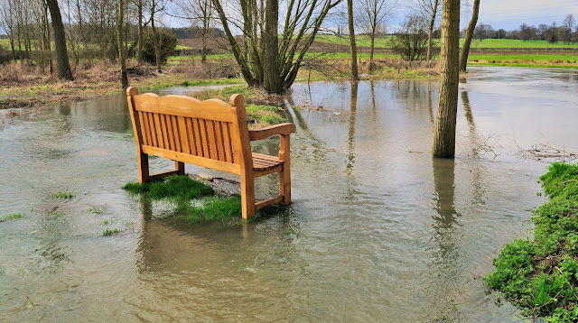
Winter brings floods to Layham & Hadleigh

Some years we appear to have a considerable amount more wet weather than others. During these times, Layham takes on a new look, and indeed, the whole area does. This year was one of the wetter ones, although not the worst we have seen. Here are some of the images I have taken when we have experienced large rainfalls.


The seat in the conservation area. You needed wellingtons to reach it, and the view was a bit different from normal. Where does the river start or finish?


The path through the trees is flooded, but the odd oasis produces the occasional surprise.


... such as crocuses still managing to produce some colour.


.... and snowdrops.


It's as well that this house is standing on pillars of brick, although this year the water was not quite as deep but near enough.


Facing the other way, the garden? and tennis court of the neighbours property.


The water as it thunders under the bridge and down the overflow beside the bridge.


Walking toward Hadleigh, this is the scene which greeted me. This is normally horse grazing area!


Anyone for rugby? Not much play on Hadleigh Rugby Club grounds.


In front of the Council offices. There is, believe it or not, a footpath under this lot.


However, the Royal Mail always tries to deliver.

Saturday, 24 March 2018

Hares of Havergate Island

Just off the mainland, south of one of Suffolk’s most popular tourist hotspots lies a rare and special landscape that most casual visitors probably have no idea even exists. The British coast boasts more than 6,000 islands, but only one of them is in Suffolk.

Across the River Ore from Orford Ness, it's far more obvious and famous neighbour, Havergate Island is, in many ways, a bundle of contradictions. Just a 20-minute boat ride from the quay at Orford!

These days, no-one lives on Havergate except an abundance of wildlife. It’s been an RSPB nature reserve since just after the Second World War – and what a reserve it is.
Along with Minsmere, it was the first place in Britain for avocets to breed in 100 years, and is a magnet for exotic spoonbills and migrant waders. 
Then there are the hares, probably first brought to the island as a food source when it was inhabited by farmers. Numbers were depleted in the storm surge of 2013, but they’re still a Havergate speciality.
It was to see the hares that we booked our place on the small boat to make the 20 minute journey, in the hope of at least a few photographs.


The small vessel we travelled on.

This shot taken as we were boarding to leave the island. Orford Ness in the background with it`s Cold War structures on it. 
Orford Ness was used a lot for military purposes but these are from the height of the Cold War when the Atomic Weapons Research Establishment and the Royal Aircraft Establishment (AWRE) used Orford Ness for development work on the atomic bomb. Continuing all the way through the 1960s ominous half-buried concrete structures were built to contain these most lethal of weapons.
A visit another day I think.


Well, we had been on the island for quite a while at the various hides, but it was hares we wanted to see. Arriving at the area where we were most likely to see them, we began to wonder if we would be lucky when suddenly - there they were. Where do I point the camera being the big decision!


Sometimes they were so close that I struggled to remember to quickly zoom in - resulting in several images with chopped ears and feet!


In the end I was quite happy with the resulting images. Even if I had taken nothing, it was a privilege to see them so close and in their natural surroundings.


A little history:
Before 1948 Havergate was farmed by local marsh keepers, who recognised the potential of its rich, silty soil.They built walls and embankments against tidal flooding, inhabited the island and introduced livestock to graze the site.
At the beginning of the 20th century, Havergate was owned by a Mr Fisk, and a cottage on the island housed the Brinkley family, who eked out a living growing crops and tending wildlife. In the early 1920s, a gravel company moved in to extract shingle, which was taken down to the shore in railway buggies powered by electricity and transferred onto Thames barges.
The remains of the extraction pits, tracks and some buggies can still be seen. By the end of the 1920s Havergate was no longer inhabited, but cattle were still brought over to graze in summer, swum over at low tide, until a barge was eventually constructed to ferry them across.
Throughout the Second World War Havergate was left unattended, something which is thought to have led to the failure of sluices that had been installed to prevent flooding and stop the island being reclaimed by the tide. The walls and embankments eventually collapsed, allowing the island to be flooded in several places.
Ironically, this flooding created perfect conditions for a bird that hadn’t bred in Britain for 100 years, the avocet. Avocets were discovered nesting on the island in 1947, leading the RSPB to purchase Havergate in 1948 and to appoint warden Reg Partridge, who began the task of rebuilding the river walls and creating the lagoons that can now be seen today.

It was a great day, and well worth the visit.


Sunday, 10 December 2017

The first snow of winter

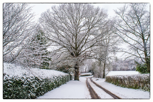
The day started with falling snow blanketing the surrounding countryside. As the morning progressed the snowfall subsided and we decided to brave the `elements` and equipped with camera, we set off to explore.


We soon found that, although it looked very pretty, it was not going to stay long. It was very `slushy` underfoot in places. Looking up the hill neat Overbury Hall did look rather winter like, as this image shows.


A close up of snow on the edge of a roof. 


Patterns formed by the snow and the structure of the barn.


The scene by Layham Mill, including the little snow covered island used by our resident swans.


A couple of images of the playing field.


And finally, Rosey, having ducked under the fallen branch, makes her way down the centre of the road. Wouldn't do that normally!

Tuesday, 5 December 2017

The American link with the Suffolk village of Shelley

Shelley is a small village and civil parish in Suffolk, England. Located on the west bank of the River Brett around three miles south of Hadleigh, it is part of Babergh district.


Probable built C13 with a north facing tower added C14, this little church was very obviously used by the Tylney family, who lived in the Shelley Hall nearby. It contains tombs and a chapel, all in the Tylney name.


Elizabeth Gosnold Tilney, sister of Jamestown colonist and explorer Bartholomew Gosnold, is buried at All Saints Church, Shelley. Many people who come to Shelley will do so to see Dame Margarett Tylney. Her effigy lies in a window embrasure to the west of the pulpit. She died in 1598, shortly before the Tudor dynasty ended.
Thomas Tylney, who married Elizabeth Gosnold Tylney, is also buried in Shelley church.


Her sleeping effigy was witness to a quite extraordinary event in the early years of the 21st Century. In 2003, archaeologists working in Jamestown, Virginia discovered the remains of a body which had been buried with obvious ceremony at the James Fort heritage site. There was a theory that it could be the corpse of Captain Bartholomew Gosnold, a Suffolk-born adventurer who led the pioneers that established the first English colony in the New World at Jamestown in 1607. A certain amount of DNA was recovered, and the only way of establishing for certain the identity of the corpse was to find a match from a source known to be of the same family. Gosnold’s sister Elizabeth Tylney Gosnold had been buried in the vault of Shelley church, and permission was given for the vault to be opened and a DNA sample obtained.
Permission was given because of “the strength of the educational and scientific rationale presented to us by the Jamestown team”. The Victorian tiles were removed from the chancel floor, then the 18th Century bricks below them, and then the 17th Century flagstones. A small amount of DNA was obtained from the corpse of Elizabeth, and lo and behold it was a match. 


A brass plaque on the chancel wall recalls the event and remembers Elizabeth - however, despite the excitement, identification of the Jamestown body still remains uncertain, as the body in All Saints’ Church – thought to be Elizabeth’s – turned out to be that of a much younger woman, possibly Anne Framlingham, who had married Philip Tylney, of Shelley Hall, in 1561 and died around 1601. It's a great story though!


North side view of Shelley church.


Another view of the front. This time with what looks like a couple sleeping rough in the porch.


Featured post for the week

Bridges and butterflies in Pipers Vale, Ipswich

Ipswich is blessed with a number of park areas, including the great Christchurch Park. The Park we visited today is called Piper`s Vale, and...