Friday, 23 April 2010

A view of Chester - Part 2 of 2

On our wander around Chester, not only the buildings were interesting, but also the people. Suddenly spotted this elderly lady with her elderly camera, standing in front to me, photographing something. Just had to take a picture of her! We had a conversation for a few minutes, and it turned out that she had several other old cameras in a carrier back in her hand!


The Old Photographer


A bronze sculpture of a Elephant, unveiled on Tuesday 16th March 2010 opposite the Town Hall. It is called Janya, and is a baby Indian Asian calf. It was donated by Chester zoo. Next we moved onto Chester Cathedral.
The C7th Mercian King, Wulfhere, is reputed to have founded a timber church on this site dedicated to St Peter and St Paul, but it was his daughter, Werburgh, who really put Chester on the map. She renounced her royal status to become a nun at Ely Abbey. Many miracles were attributed to her during her lifetime, including restoring back to life a goose that had been stolen and eaten. 
She was buried in Staffordshire and her tomb rapidly became a place of pilgrimage. Following the threat of Danish raids in the C9th her relics were brought to Chester as a place of safety and were placed in the Church of St Peter and St Paul. Queen Ethelfleda, the grand daughter of Alfred the Great, founded a monastery in Chester and rededicated the church to St Werburgh. The new monastery continued to enjoy royal patronage and flourished. A splendid shrine was built in her honour. 


The Water of Life


I loved this statue in the Cathedral cloisters. The piece was designed for the Cloister Garden of Chester Cathedral in association with the 900th Anniversary celebrations of the foundation of the Benedictine Abbey of St Werburgh, on this site in 1092.
The water feature depicts (if you know the story) "the encounter between Jesus and the Woman of Samaria, showing their shared bowl overflowing with water. The theme of water also suggests a link to how the Benedictine monks water supply was at the centre of the cloister garden." 


Looking toward the great west window in Chester cathedral. It is Perpendicular Gothic with 20th-century stained glass by W. T. Carter Shapland (1961) as the Victorian stained glass was blown out by a bomb in 1941.The picture shows the massive space inside this building. 


And facing the other way toward the altar


The Gothic Chapter House 

Chester was the last English city to fall to the Normans in 1069. To bring the area firmly under Norman control, William I appointed his nephew, Hugh d’Avranches, as Earl of Chester. He built Chester Castle and transformed the Saxon Church into a large and well endowed Benedictine Monastery, with a Norman church around the shrine of St Werburgh. Building began at the east end where the monks held services and gradually extended west. Work began on the domestic buildings including the cloisters.


Elephant and castle bench ends - note the feet of a horse, demonstrating that the carver had learnt of elephants by word of mouth.


During the Commonwealth, the Puritans smashed all the stained glass and replaced with plain glass. The hands of the Greene monument (above) in the nave were removed because they were joined in prayer, which was regarded as a popish gesture. 


The space beneath the south west tower was set up as the Consistory court in 1636. The court dealt with all the legal work of the diocese, including handling wills and probate, issues of matrimony as well as heresy, blasphemy and slander. This is the only surviving court in England. The judge, called the Chancellor, sat at the canopied seat at the head of the table, with a clerk on either side. The other officers of the court sat round the table. The Apparitor was responsible for the smooth running of the court and sat in the high seat in the corner, where he could see everything going on.


Part of the Cloisters


A view of the Shropshire Union Canal from the City walls. 

The Shropshire Union Canal, nicknamed the "Shroppie" is a navigable canal in England. The Llangollen and Montgomery canals are the modern names of branches of the Shropshire Union system and lie partially in Wales.
The canal lies in the counties of Staffordshire, Shropshire and Cheshire in the north-west English Midlands. It links the canal system of the West Midlands, at Wolverhampton, with the River Mersey and Manchester Ship Canal at Ellesmere Port, Cheshire, 66 miles (106 km) distant. It runs southeast from Ellesmere Port on the River Mersey to the Staffordshire and Worcestershire Canal at Autherley Junction in Wolverhampton.
The canal was the last trunk narrow canal route to be built in England. It was not completed until 1835 and was the last major civil engineering accomplishment of Thomas Telford.


Chester Castle with some history, courtesy of English heritage.

Chester Castle was founded by William the Conqueror in 1070 and became the administrative centre of the earldom of Chester. The first earth and timber ‘motte-and-bailey’ castle probably only occupied the area of the inner bailey. In the 12th century it was rebuilt in stone and the outer bailey added.
I wondered what this meant so turned to Wikipedia and learnt `A motte-and-bailey castle is a fortification with a wooden or stone keep situated on a raised earthwork called a motte, accompanied by an enclosed courtyard, or bailey, surrounded by a protective ditch and palisade. Relatively easy to build with unskilled, often forced, labour, but still militarily formidable, these castles were built across northern Europe from the 10th century onwards, spreading from Normandy and Anjou in France, into the Holy Roman Empire in the 11th century. The Normans introduced the design into England and Wales following their invasion in 1066. Motte-and-bailey castles were adopted in Scotland, Ireland, the Low Countries and Denmark in the 12th and 13th centuries. By the end of the 13th century, the design was largely superseded by alternative forms of fortification, but the earthworks remain a prominent feature in many countries` So now we know!
In 1237 the last earl died and the castle, with the earldom, was taken over by the king. In 1265, during the Barons’ War, it was held for ten weeks by supporters of Simon de Montfort against the men of Prince Edward, son of Henry III.
During the reigns of Henry III and Edward I the castle served as the military headquarters for the conquest of Wales and much building was carried out, especially in the outer bailey. In the later medieval period the monarch rarely stayed at the castle, but it continued to serve as the centre for county administration. We were limited in our time in the beautiful City of Chester so we only took this one image and did not explore the interior. perhaps another day.


Another view of Chester Cathedral, seen from our wall walk, 


On the Shropshire Union Canal we came across this step lock.


Watching people operating the lock and maneuvering their barge through it.

A great part of the world that we had not visited before. We need to re-visit some more of it as time was somewhat limited. One for the diary!


A view of Chester - Part 1 of 2

One of the first places we passed on our way to Chester town centre, was some Roman remains. The History of Chester can be dated back to the Romans who named Chester Deva (pronounced Dewa) after the spirit of the River Dee. Roman Chester was considered as important then as Londinium (London). The Romans didn't just create a small fort here, they meant to stay, building a city for their 20th Legion. The Romans built Chester as a strategic position at the centre of Roman Britain, with plans to sail from the River Dee to invade Ireland and North Wales. 


In the Roman gardens


Part of the Chester Roman Amphitheatre - the largest amphitheatre to be found in Britain. The Chester Roman Amphitheatre, was built to serve the fort of Deva. It was used as a multi-purpose entertainment centre for the troops stationed here, and also as a training ground.


Installed in 1899, the Eastgate Clock is positioned on the bridge over Eastgate Street in the city of Chester, the original entrance to the Roman fortress of Deva Victrix. The whole structure of the public clock and gateway, as one, is classified as a Grade I listed building and the tower clock is believed to be the second most photographed clock in England to “Big Ben”, officially known as Elizabeth Tower, at the Palace of Westminster in London.
Proposed as a commemoration for the Diamond Jubilee of Queen Victoria (1897), JB Joyce & Company was commissioned to manufacture and install the clock mechanism, with the clock design by Chester Architect John Douglas. The clock officially began ticking on the 24th of May, 1899. 
The clock tower has four, 4ft 6 inch dials that were originally gas lit, but are now powered by electricity with battery back-up and a computer chip which keeps the clock to precise time. 


The original Roman entrance gate and the Eastgate clock.


One of the Chester City Wall towers.


Number 33 Eastgate Street, Chester, at the corner of Eastgate Street and St Werburgh Street, Chester, England, was built in 1859–60 for the Chester Bank. and it continues in use as the NatWest Bank. It is recorded in the National Heritage List for England as a designated Grade II* listed building. It is in Neoclassical style, but was built at the time that the Black-and-white Revival was underway in the city, and was therefore the subject of much criticism for being "out of place". At a quick glance, I can see what they meant. 


Buildings in Eastgate street, Chester. Although Chester is known for its many original Tudor buildings, many others , like Eastgate Street, are very much Victorian fakes!


Hugh of Avranches (1071-1101: First Earl) in Northgate Street. Quite a history, has Hugh. He is one of three figures on buildings in `Shoemakers Row` - it`s not really clear where the name came from.


The Latin motto `Antiqui Colant Antiquum Dierum` or Let the ancients worship the ancient of days. The figure is Edward VII. He was created Prince of Wales and Earl of Chester on 8 December 1841, Earl of Dublin on 10 September 1849 or 17 January 1850, a Knight of the Garteron 9 November 1858, and a Knight of the Thistle on 24 May 1867. Some folks get it all! 


The Nine Houses, of which only six remain, are in Park Street, Chester.. The row of houses is recorded in the National Heritage List for England as a designated Grade II listed building. They face the eastern portion of Chester city walls.
The houses are the only surviving pre-19th-century almshouses in Chester. They were built in about 1650. By the 1960s the houses were in a dilapidated state and were in danger of collapse. There were campaigns to preserve them led by the Chester Civic Trust and the Chester Archaeological Society. A report was prepared by the Society for the Protection of Ancient Buildings, following which they were renovated and rebuilt by Chester City Council in 1968–69. The end wall had to be repaired in old brick, and the rear wall was completely rebuilt.
The row consists of six adjoined cottages in two storeys. Each cottage consists of a single bay. The lower storey is constructed in brick on a low sandstone plinth, with stone dressings around the entrance doorways that contain oak-boarded doors. The upper storey is timber-framed and jettied, and has a gable that is jettied further. In the lower storey of each cottage is a 12-pane horizontally-sliding sash window. Each upper storey contains a 16-pane vertically-sliding sash window.
PS Jettying is a building technique used in medieval timber-frame buildings in which an upper floor projects beyond the dimensions of the floor below - just in case you are unsure of my odd word!


Thursday, 22 April 2010

The Pontcysyllte Aqueduct

The start of our short break!  First a family visit, and then onto the Pontcysyllte Aqueduct. The pictures and write-up sounded good. so we were looking forward to seeing it.


Approaching our destination, we stopped for a while to admire the river Dee as it flowed through the town. Noisily (above) and peacefully (below).


And then our first sight of our objective.


Designed and built by Thomas Telford and Williams Jessop, Pontcysyllte means 'the bridge that connects', a magnet for those who want to experience one of the most remarkable achievements of the industrial revolution.
You can walk across Pontcysyllte, or save your legs and take a leisurely boat ride - we did neither! Well, we did walk underneath and along the path to the edge of the bridge.
The Pontcysyllte Aqueduct is a navigable aqueduct that carries the Llangollen Canal across the River Dee in the Vale of Llangollen in north east Wales. The 18-arched stone and cast iron structure is for use by narrowboats and was completed in 1805 having taken ten years to design and build. It is the longest aqueduct in Great Britain and the highest canal aqueduct in the world.
The aqueduct was to have been a key part of the central section of the proposed Ellesmere Canal, an industrial waterway that would have created a commercial link between the River Severn at Shrewsbury and the Port of Liverpool on the River Mersey. Although a cheaper construction course was surveyed further to the east, the westerly high-ground route across the Vale of Llangollen was preferred because it would have taken the canal through the mineral-rich coalfields of North East Wales. Only parts of the canal route were completed because the expected revenues required to complete the entire project were never generated. Most major work ceased after the completion of the Pontcysyllte Aqueduct in 1805. 
The structure is a Grade I listed building and a World Heritage Site, so an important site and well worth the visit. 


The view from the underside path.


Moored up near the aqueduct.


Crossing the canal by barge


Hand Sculpture depicting local industry at Trevor Basin near the Pontcysyllte Aqueduct All in all, a spectacular place and well worth the visit.

Home  or  Day Two

Saturday, 27 February 2010

The Tithe War

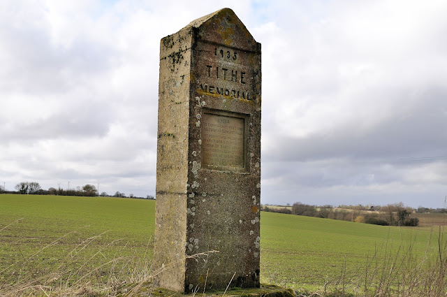
The Elmsett tithe memorial is one of several reminders in Suffolk of the battle fought by small farmers against the demands from the Church for payment of tithes. It also recalls a now largely forgotten but rather murky period in East Anglian local politics. 
In the 1930s, agriculture in England experienced a deep depression, and it was very hard to make the land pay. The Church of England had undergone much modernisation over the previous century, but even so, there were still parishes where the tithe system meant that even small landowners were legally obliged to contribute a proportion of their income to the church for the upkeep of its incumbent. This was the case even if they were not Anglicans, which in Suffolk many were not. In addition, many of the smaller landowners were supporters of the Liberal Party, but the governing Conservative Party, which many of the larger landowners supported, stood foursquare behind the Church in the matter.
If the landowners refused to pay, the courts could enforce tithe seizures by bailiffs, who in many cases would take goods valued at far more than the unpaid tithes.
The Elmsett Tithe Memorial recalls such an incident, just one of many, in which possessions were seized from the home of a land owner in lieu of payments to the Church. It reads 1934. To commemorate the Tithe seizure at Elmsett Hall of furniture including baby's bed and blankets, herd of dairy cows, eight corn stacks and seed stacks valued at £1200 for tithe valued at £385.
Charles Westren, the farmer in question, had refused to pay his tithes to the church. After the seizure, he set up this monolithic concrete memorial on the edge of his land facing into the gateway of Elmsett church, so that anyone leaving a service would be reminded of the injustice of the system. Westren eventually emigrated to America during the Second World War. The legal abolition of the tithes system in England and Wales was set in motion after the War, the system coming to a final end in the 1970s, by which time very few tithes were still collected because of the cost of doing so. 


The memorial is set just opposite the church gates so you cannot fail to see it as you leave. A reminder of the injustice people felt.


Tithe memorial, Elmsett, Suffolk

However, it is salutary for us to recall that the tithe controversy has lingered well into the collective folk memory of modern Suffolk. The tithe protesters received strong support from, among others, the writers Henry Williamson and Doreen Wallace, who would later recall the events in her book The Tithe War, both of whom had small farms in East Anglia.
Their articles in London newspapers had the effect of drumming up considerable discussion, and both writers' sympathies with the British Union of Fascists encouraged that organisation to support the tithe protesters.
The writer George Orwell documented the struggle in his novel A Clergyman's Daughter, as did Henry Williamson in A Norfolk Farm. People in this part of East Anglia gave strong support to the British Union of Fascists in the 1930s, who were vocal in their support for the tithe rebels. Ronald Creasy, a local farmer, was elected as a British Union Councillor for Eye, principally on the issue of the tithe protests. 
In 1934, Doreen Wallace and her husband Rowland Rash refused to pay their tithes for Wortham Manor farm. For sixteen days, some fifty members of the British Union of Fascists surrounded the farm to stop the court's bailiffs gaining access to remove goods. They were confronted by lines of police drafted in from Ipswich, and then many were arrested on a technicality and carted off to prison in Norwich. Hard to imagine, now. The events are remembered by a memorial similar to that at Elmsett in a country lane near Wortham Manor. 
[Just think - in 2018 this was one report of the CofE value: "The Church’s property portfolio and investments are immense. It is sitting on a combination of ancient endowments and investments worth £8.3bn, which last year alone increased by £400m. These earnings are enough to make the CofE by far the UK’s biggest charity, with an income more than three times that of Oxfam."]


Friday, 5 February 2010

Framlingham and Orford castles

Framlingham Castle is an externally perfect moated 12th century castle. The fortress consists of a curtain wall punctuated by 13 square towers. The curtain wall has remained in an exceptional state of preservation despite the castle's advanced age, and the renovations of later centuries, which saw it used as a school, a poorhouse, and a prison.!

Now for some history (courtesy of Wikipedia):
The site was probably used for fortifications as early as the 6th century, but of those early structures nothing remains. Framlingham enters history more firmly at the turn of the 12th century when the estate was given by Henry I to Roger Bigod.
It seems likely that Bigod built a simple wooden motte and bailey castle at Framlingham, but it was left to his second son, Hugh, later the first Earl of Norfolk, to replace that structure with one of stone. That fortification was ordered dismantled by Henry II about 1175, but it was rebuilt by Hugh's son Roger, the Second Earl of Norfolk, about 1190. It is largely Roger's work that visitors can see today.
So strong were the towers built by Roger Bigod that a central keep was considered unnecessary for the defences.
However, the castle had not been in existence long before it did indeed fall to besiegers. That occurred when Roger Bigod supported the baron's resistance to King John that resulted in the Magna Carta. John was not the forgiving sort, and he besieged Framlingham in 1216. The castle garrison held out only two days before surrendering, however, King John did not have long to live, and Framlingham was restored to the Bigods following the king's death.

The castle changed hands several times over the ensuing centuries until it finally came to the Howard family. Thomas Howard, Duke of Norfolk, added much of the Tudor brickwork in the late 15th century. Finally, in 1635 the castle was sold to Sir Robert Hitcham.
Following Hitcham's death the castle was used as a poorhouse, and later, to house victims of the Plague. Over the intervening centuries, the castle has been used variously as a courthouse, drill hall, meeting hall, workhouse, and a fire station, before finally passing into the hands of English Heritage, whose work it has been to preserve the castle.
Though the interior of Framlingham Castle offers little to recall its days of power, the exterior, including the curtain wall and towers, offer a very enjoyable day out.


A couple of images of the castle from the other side of the Mere. 
Two large lakes, called meres, were formed alongside the castle by damming a local stream. The southern mere, still visible today, had its origins in a smaller, natural lake; once dammed, it covered 9.4 hectares (23 acres) and had an island with a dovecote built on it. The meres were used for fishing as well as for boating, and would have had extensive aesthetic appeal. It is uncertain exactly when the meres were first built. One theory suggests that the meres were built in the early 13th century, although there is no documentary record of them at least until the 1380s. Another theory is that they were formed in the first half of the 14th century, at around the same time as the Lower Court was constructed. A third possibility is that it was the Howard family who introduced the meres in the late 15th century as part of their modernisation of the castle.


Sir Robert Hitcham died in 1636 leaving the castle and the manor to Pembroke College in Cambridge, with the proviso that the college destroy the internal castle buildings and construct a workhouse on the site instead, operating under the terms of the recently passed Poor Law. 
After the collapse of the power of the Howards, the county of Suffolk was controlled by an oligarchy of Protestant gentry by the 17th century and did not play a prominent part in the English Civil War that occurred between 1642–6. Framlingham Castle escaped the slighting that occurred to many other English castles around this time.
(Slighting? - Slighting is the deliberate destruction, partial or complete, of a fortification without opposition, to render it unusable as a fortress - so now we know!)
Hitcham's bequest had meanwhile become entangled in the law courts and work did not begin on the workhouse until the late 1650s, by which time the internal buildings of castle were being broken up for the value of their stone; the chapel had been destroyed in this way by 1657.

The workhouse at Framlingham, the Red House, was finally built in the Inner Court (as shown above) and the poor would work there so they were eligible for relief; it proved unsatisfactory and, following the mismanagement of the workhouse funds, the Red House was closed and used as a public house instead.The maintenance of the meres ceased around this time and much of the area returned to meadow. In 1699 another attempt was made to open a poorhouse on the site, resulting in the destruction of the Great Chamber around 1700. This poorhouse failed too, and in 1729 a third attempt was made – the Great Hall was pulled down and the current poorhouse built on its site instead.Opposition to the Poor Law grew, and in 1834 the law was changed to reform the system; the poorhouse on the castle site was closed by 1839, the inhabitants being moved to the workhouse at Wickham Market.
The castle continued to fulfill several other local functions. During the outbreak of plague in 1666, the castle was used as an isolation ward for infected patients, and during the Napoleonic Wars the castle was used to hold the equipment and stores of the local Framlingham Volunteer regiment. Following the closure of the poorhouse, the castle was then used as a drill hall and as a county court, as well as containing the local parish jail and stocks.


View of the inner court.


The Lower Court (l) and Postern gate (r)


A number of carved brick chimneys dating from the Tudor period can be seen around the Inner Court, each with a unique design; all but three of these were purely ornamental, however, and historian R. Allen Brown describes them as a "regrettable" addition to the castle from an architectural perspective. Two of the functional Tudor chimneys make use of original mid-12th century flues; these two chimneys are circular in design and are the earliest such surviving structures in England.


And so to Orford castle, in the village of Orford, Suffolk, located 12 miles (20 km) northeast of Ipswich, with views over the Orford Ness. It was built between 1165 and 1173 by Henry II of England to consolidate royal power in the region. The well-preserved keep, described by historian R. Allen Brown as "one of the most remarkable keeps in England", is of a unique design and probably based on Byzantine architecture. The keep still stands among the earth-covered remains of the outer fortifications.
So here we have Framlingham Castle with no keep, and Orford with a magnificent keep and no outer walls, within a few miles of each other.


Again, a huge history - (Wikipedia). Prior to the building of Orford Castle, Suffolk was dominated by the Bigod family, who held the title of the Earl of Norfolk and owned key castles at Framlingham, Bungay, Walton and Thetford. Hugh Bigod had been one of a group of dissenting barons during the Anarchy in the reign of King Stephen, and Henry II wished to re-establish royal influence across the region. Henry confiscated the four castles from Hugh, but returned Framlingham and Bungay to Hugh in 1165. Henry then decided to build his own royal castle at Orford, near Framlingham, and construction work began in 1165, concluding in 1173.
The Orford site was around two miles (3.2 km) from the sea, lying on flat ground with swampy terrain slowly stretching away down to the river Ore, about half a mile (0.8 km) away.
The design of the keep was unique, and has been termed "one of the most remarkable keeps in England" by historian R. Allen Brown. The 90-foot-high (27-metre) central tower was circular in cross-section with three rectangular, clasping towers built out from the 49-foot-wide (15-metre) structure. The tower was based on a precise set of proportions, its various dimensions following the one-to-the-root-of-two ratio found in many English churches of the period. 
The keep was surrounded by a curtain wall with probably four flanking towers and a fortified gatehouse protecting a relatively small bailey; these outer defences, rather than the keep, probably represented the main defences of the castle.


The Merman of Orford

In London. the athletic and active Henry II sits on the throne of England, plotting an invasion of Ireland that will lead to nearly a thousand years of pain. In Canterbury cathedral Thomas Beckett is the Archbishop, asserting an independence for the church that will one day cause his death. In Oxford a group of scholars, recently expelled from Paris, arrive and settle down.
In Orford, on the Suffolk coast, the world is the sea. What comes out of it, how it behaves, what goes into it; all these are the concerns of Orford people.
On one day in 1167, a group of men are fishing in the sea a mile off Orford Ness, their small boats rising and falling on the swell. Suddenly, one of their nets is pulled and twisted with great ferocity. With practised expertise the fishermen begin to pull it in, only to find that they have not caught a dolphin or a seal, as they had suspected, but a wild looking man.
Ralph Coggeshall, the Abbott's chronicler, takes up the story:
'Men fishing in the sea caught a wild man in their nets. He was naked and was like a man in all his members, covered with hair and with a long shaggy beard. He eagerly ate whatever was brought to him but if it was raw he pressed it between his hands until all the juice was expelled. He would not talk, even when tortured and hung up by his feet. Brought into church, he showed no signs of reverence or belief. He sought his bed at sunset and always remained there until sunrise. He was allowed to go into the sea, strongly guarded with three lines of nets, but he dived under the nets and came up again and again. Eventually he came back of his own free will. But later on he escaped and was never seen again.'
Belief in mermaids and mermen has existed since earliest times; most commonly they are represented as having the head and body of a woman or man and a fishtail instead of legs. While mermaids are often described as having great beauty and charm, which they used to lure sailors to their deaths, mermen (of which there are far fewer stories) are generally considered uglier and less kindly, although encouraging sailors to drown doesn't sound too friendly. Most tales suggest mermen have no interest in mankind, although they have been cited as being instrumental in the production of huge storms and the sinking of ships in revenge for man’s mistreatment of a beloved mermaid.
The story of the Orford Merman is still much talked about today, a memorial to him hanging in the market square - used as the logo for The Butley Orford Oysterage. It has now been put to music in a wonderful new composition by Joanna Lee, composer in residence to the Aldeburgh Music Club. The music was performed by the Aldeburgh Music Club choir as part of their 60th anniversary celebrations in 2012.


Thursday, 7 January 2010

Cold and Frosty start to 2010

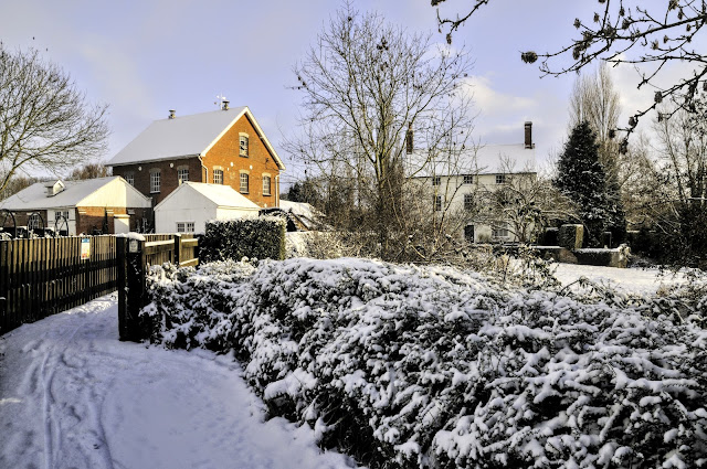
The start of 2010 was cold and snowy! It is a different world around you when it is covered in snow, and as long as the sun is out, there can be some great photos to be had. That is assuming you can stay upright on your walks!


So, not far from home, and on my usual walking trail, my first image is of the old mill and mill house.


Then onto St Andrews Church.


One lone tree against a blue sky and white fields.


Obviously not `clear` of snow!


Looking back toward the church, and do I detect an attempt to sand the lane?


Looking across the Hadleigh Cricket ground. Not playing today then?


Bird tracks on the frozen waterways. I wonder what they make out of all the ice on their water?


And the cows looking for green - it was here yesterday!

 Home