Thursday, 12 June 2008

The City of York - Day one

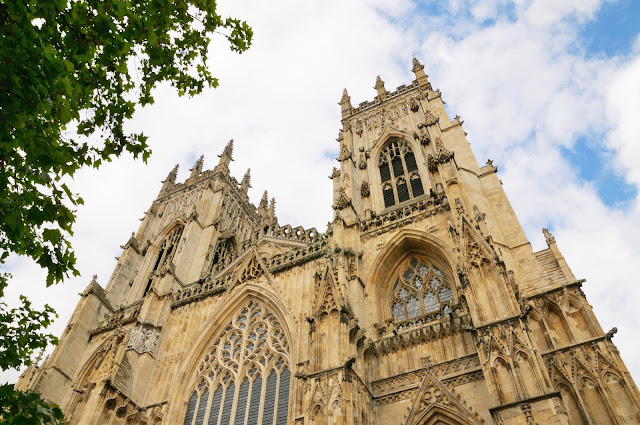
York is a historic walled city in North Yorkshire, The city was founded by the Romans as Eboracum in 71 AD. It became the capital of the Roman province of Britannia Inferior, and later of the kingdoms of Northumbria and Jórvík. In the Middle Ages. York grew as a major wool trading centre and became the capital of the northern ecclesiastical province of the Church of England, a role it has retained.
In the 19th century, York became a hub of the railway network and a confectionery manufacturing centre. The economy of York is now dominated by services.


York's cathedral church is one of the finest medieval buildings in Europe. The Minster is also known as St Peter's, its full name being the 'Cathedral and Metropolitical Church of St Peter in York'. In the past the church sat within its own walled precinct, known as the Liberty of St Peter.
The remains of the Basilica, the ceremonial centre of the Roman fortress, have been found beneath the Minster building.
The first Christian church on the site has been dated to 627 and the first Archbishop of York was recognised by the Pope in 732. 
A stone Saxon church survived Viking invasion in 866 but was ransacked by William the Conqueror's forces in 1069. William appointed his own Archbishop, Thomas, who by the end of the century had built a great Norman cathedral on the site. 
The present Gothic-style church was designed to be the greatest cathedral in the kingdom. It was built over 250 years, between 1220 and 1472. 
As the natural centre of the Church in the North, the Minster has often played an important role in great national affairs - not least during the turbulent years of the Reformation and the Civil War. 


The Shambles (officially known as just Shambles is an old street in York, England, with overhanging timber-framed buildings, some dating back as far as the fourteenth century. It was once known as The Great Flesh Shambles, probably from the Anglo-Saxon Fleshammels (literally 'flesh-shelves'), the word for the shelves that butchers used to display their meat. As recently as 1872 twenty-five butchers' shops were located along the street, but now none remain.
The street was mentioned in the Domesday Book of 1086. Many of the current buildings are from circa 1350-1475.
Although the butchers have now vanished, a number of the shops on the street still have meat-hooks hanging outside and, below them, shelves on which meat would have been displayed. The shops currently include a mixture of eateries and souvenir sellers, but there is also a bookshop and a bakery. 


The homeless of York. The man sleeping on the bench would make a picture I thought, and then realised that there were actually two sets of legs!


So important did York become in Roman Britain that a royal palace was built in the city, and the emperor Septimus Severus stayed here with his imperial court in the years 209-211. By the 4th century Eboracum was the capitol of southern Britannia.
The Emperor Constantius I visited here in 306 - and promptly died. His son, Constantine the Great, founder of Constantinople and the first Christian Emperor of Rome, was proclaimed emperor in York. The traditional site of his crowning is preserved under York Minster. 
The headquarters of the legions was on the site of the Minster. Roman remains were uncovered beneath the church during restoration work, including a 31 ft. high column, which has been re-erected near the south entrance to the Minster. 


Another view of the Minster in York completing our first wander in York!


Saturday, 24 May 2008

Bressingham Steam with Adam


Bressingham Gardens and Steam Experience is a unique combination arising out of the passions of founder Alan Bloom, whose profession of nurseryman and gardener and hobby of a steam powered collection of trains and traction engines led to the leisure destination of Bressingham Gardens and Steam Museum. 

It's a great family place and we were sure Adam would enjoy this (as well as ourselves!)


This was the engine that adam and dad went on, although I am unsure which of the four routes they travelled. They enjoyed themselves anyway.


....... as you can see by Adams face!


and then a little celebration dance afterwards.


And now it is lunch time Nana.


The three-abreast Gallopers are Bressingham centre piece. It is one of the finest to be seen anywhere. Built by Savages of Kings Lynn in 1897 and owned and operated by the Thurston family of Norfolk until 1934, the Gallopers later operated at Whitley Bay and ended up in Scotland before finding a home at Bressingham. The engine was originally built by Tidmans of Norwich but has been completely rebuilt at Bressingham. The organ - a Bruder-built, 48 keyless Chiappa - accompanies the Gallopers as they reach up to six revolutions per minute and swing out some 15 degrees.

The set came to Bressingham in 1967 and has been delighting young and old as the heart of the site ever since.


Adam with dad having a gallop.


A peek in a signal box and an amazing array of coloured levers.


The engine emerging from the garden area


This colourful corner of the garden caught my attention.


Sunday, 21 October 2007

Australia 2007 - our final few days

Sunday 21st October We're off to Jenolan Caves today with Gra and Jane They are one of the finest and largest cave systems in the world. Because there are so many caves we had to choose which to go in.


We went in the Orient caves and then we went in a self guided one through the Devils Coach House. Outside the cave, the Devil's Coach House is a cavernous natural archway in the mountainside, named after the ghostly vision reported by a camper, Luke White, who claimed he had seen the devil himself charge through aboard a horse-drawn coach. The roof of the arch is 57m at its highest point.


Some of the amazing Stalactites and stalagmites we have ever seen. Although the first two caves were very different they were both amazing in their own right. It is incredible to imagine how explorers managed to find their way through the caves with only a candle for light, a rope and hobnail boots. It was very early on that the importance of these caves was recognized and sanctions were made to preserve the caves in their original state. 
The caves and conservation reserve are one of the eight protected areas that was inscribed in 2000 to form part of the UNESCO World Heritage-listed Greater Blue Mountains Area. 


During lunch we were entertained by these amazing birds 

We returned to site for drinks and later went into town for dinner. A very enjoyable day. 
It has been great to be with Tez and John and Graham and Jane and although Tez and John are off early in the morning we are going to spend another day with Graham and Jane before heading to Penrith.

Some facts (gleaned from the internet) about the Blue Mountains: 
The Blue Mountains were discovered in 1813 through a successful expedition led by Gregory Blaxland, William Lawson, and William Charles Wentworth. Early ideas of shaping the area into a national park came about in 1932, upon the proposal of conservationist Myles Dunphy. To preserve its geographical and cultural significance, the park was recognized as Australia’s 14th World Heritage Site in 2000.

Where are the Blue Mountains?
Situated in eastern Australia’s New South Wales, the range of Blue Mountains can be found approximately 80 kilometers west of state capital Sydney. The national park is a 90-minute drive from Sydney through the M4 motorway. A more scenic route can also be taken past the Hawkesbury along Bell’s Line of the Road. En route to Blue Mountains entails a leisurely drive across multiple thoroughfares, small towns, and farms. On the outskirts of the park is the town of Katoomba.

Why the Blue Mountains are blue?
he expansive eucalypt forests covering the Blue Mountains are regarded by many as the primary source of the blue haze. But contrary to popular belief, it is simply the optical phenomenon called the Rayleigh Scattering that is causing the area’s blue tinge. The phenomenon asserts that the sun’s ultraviolet rays are scattered by the particles in the atmosphere that are smaller than the wavelength of the light. This effect creates a blue-greyish color to objects at a distance, including the sky and mountains.

Monday 22nd October After lunch we all went to Kanangra- Boyd N.P and to various look outs. It was 29 km off the road down an unmade track. 


The first lookout was over Kanangra Creek where you could see the top of Mount Cloud Maker and the blue Mountain Ridge and the next one we were able to see the Kanangra Deep. The vertical cliffs were the Kanangra Walls which dropped five hundred meters. Because the day wasn’t misty the views from here were brilliant. 


This little fellow was in the carpark. 


We walked to some caves known as the dance floor caves. This was part of the old stock route which came from the Burragorang Valley. The travelers and settlers used to gather together at this spot. It became as popular as a meeting spot that in 1891 a dance platform was erected in the cave. The timber boards have now all rotted away but it is still a favorite resting place for bush walkers. 

Tuesday 23rd October Time to move on, say bye to Graham and Jane and head back toward Sydney. 


Just a last few things to see in the Blue Mountains National Park, Govetts leap was first on the list. We were able to look from the lookout but unfortunately not able to walk the paths due to fire damage. 


The story of Govett and his 'leap' belongs more to mythology than to fact. It is claimed that a bushranger named Govett, being chased by the police, spurred his horse on and died rather than surrender as he disappeared off the waterfall which drops 450 m into the Grose Valley. Unfortunately, even though the story deserves to become part of Australian history, it is more likely that Govett's Leap was named after William Romaine Govett, a young surveyor who arrived in Sydney in 1827, spent many years surveying the Blue Mountains and the Hawkesbury area, and returned to England in 1834 after the government had reduced his surveying establishment.
The evidence for the 'leap' being simply named after Govett is overwhelming. In the early 1830s the Three Sisters were known as Govett's Point, suggesting that he was well known and admired in the area. And, in 1835, Govett wrote 'The bold broken nature of the country on either side is peculiarly grand, and the streams which at first commence in swamps soon make their way into inaccessible gullies, until they arrive at the cliffs of the main channel where they fall in cascades....The most remarkable of these cascades is the one near the Weatherboarded Hut [Wentworth Falls] and that which falls into the head of the Grose River; which the surveyor general named 'Govett's leap' from the circumstance of my first having come upon the spot when surveying with Mr Rusden.' 


Then for a spot of humour - don`t think this would go down too well in the UK 


Actually a large and well known van hire company. 


We went from here to Evans lookout. We were going to walk the Canyon walk but this was classed as difficult and a four hour walk. 


Wentworth Falls was next. It was a brilliant view but the water level was almost non existent. We walked round to various vantage points. Prince's Rock lookout being the best. On return we had lunch and drove on to Penrith and the last of our camp sites. This was also the site we visited first almost a month ago! Where has the time gone? 

Friday 26th October Well the holiday is over. We drove the van safely back to the depot - everything being OK. From there we caught a train to Central and then another to the airport. 


Singapore Airbus 3802 on its inaugural flight to Sydney - and we were there to see it taxi in. 


Our flight for home 

We arrived in good time and were able to get a window seat on the flight. Unfortunately the flight was delayed by an hour as the airport closed due to severe storms. We did however see the new Airbus before it took off for its return flight to Singapore. Then it was our turn and so ended an amazing holiday in Australia. 


Wednesday, 17 October 2007

Richmond and into the Blue Mountains

Wednesday 17th October Off today heading for Richmond, passing over the River Lidell near Muswellbrook. This provides a source of power for the surrounding area. There is vast mining of coal and sand in the area. Where on earth is Muswellbrook?: Well, it is a town in the Upper Hunter Region of New South Wales, Australia, about 243 km north of Sydney and 127 km north-west of Newcastle. Geologically, Muswellbrook is situated in the northern parts of the Sydney basin, bordering the New England region.


Ever onward and over the very old Bulga bridge and eventually a stop at the halfway house. I'd forgotten about the road houses as this is the first one we have been to on this visit. They are much more a thing on the western side where there are such great distances between places. 
We are then dropped down in to the lower Hunter valley and some of the serious wine regions of the area. There is also a lot of fruit and veggies grown around here. 
The scenery on the way was beautiful. Some of the colours of the trees were great. We are now in Richmond and have booked into a Great Western for the night as there is no camp site here. We are now ready for our journey along the Bells Line of road. 

Thursday 18th October Along the Bells Line Road today, through the Blue Mountain N.P. We were away by 8.00 as we thought there would be plenty to see.


The heat from these bushfires assisted these seed pods to burst open, shooting their seed widely.

We stopped at Mount Banks picnic spot but were unable to drive into the park due to structural damage caused by a massive forest fire in December/January. However we did walk in so we could get some pictures. The fire had gutted places, but new growth was appearing. 


We then drove onto Pierces Pass where we walked a few kilometers so we could see the view of Grose Gorge. It was a bit rough going but well worth it. The view was awe inspiring. This was a place you could have sat all day and never tired of the view. 


Waterfall in Mount Tomah Botanic Garden


One small lizard sunning himself on a rock


From here we went back to Mount Tomah Botanic Garden which had been closed when we went by at 8.30. We had lunch and a stroll round some of the gardens, really just to pass the time.


We continued our drive towards Lithgow taking a detour to Mt Wilson the way. We went to see the cathedral of ferns and the giant eucalyptus tree. It was all a bit overrated we thought. From here to Lithgow where we found a camp site and stopped for the night. 

Friday 19th October Today we traveled from Lithgow to Oberon We shopped first at Lithgow. We were quite prompt as we wanted to get washing done before Graham and Jane arrived. 


Once gathered we spent the day catching up and making arrangements for the next two days. It really was good to catch up with the family as they are all such fun to be with.
On the Saturday,  we all went to Katoomba to visit the scenic world. This included a ride on the scenic railway, scenic cable car and the scenic skyway. 


This was the cable car which looks a long way up even at the start!


... But when you are on the cable car and look down to the shadow of it on the canyon floor!! That's a long way!


Cockatoo (a parrot) posing near the car entrance


The Scenic Railway is an incline railway now used for tourism. The steepest section of track is on an incline of 52 degrees contained within a total distance of 310 metres (1,020 ft). It was originally constructed for a coal and oil shale mining operation in the Jamison Valley in the 1880s, in order to haul the coal and shale from the valley floor up to the escarpment above. From 1928 to 1945 it carried coal during the week and passengers at weekends. The coal mine was closed in 1945 after which it remained as a tourist attraction.

We walked from the scenic skyway for half hour and saw several views and then returned and took the railway to the railway bottom and took the Lilly Pilly walkway which took us through the old mine. From here we caught the cable car which took us back to the top. We jumped back onto the replica trolley tour which took us round all the interesting sights around Katoomba and Laura village. Having done this we drove back to Echo Point and took pictures of the Three Sisters as the sun was dipping. Tez and John did part of the Giant Stairway which took them across to the first of the Three Sister.


The famous `must see` as a tourist - The Three Sisters with some local information about this famous site: 
The Three Sisters is the Blue Mountains’ most spectacular landmark. Located at Echo Point Katoomba, around 2.5 kilometres from the Great Western Highway, this iconic visitor attraction is experienced by millions of people each year. 
The Three Sisters is essentially an unusual rock formation representing three sisters who according to Aboriginal legend were turned to stone.
The character of the Three Sisters changes throughout the day and throughout the seasons as the sunlight brings out the magnificent colours. The Three Sisters is also floodlit until around 11pm each evening looking simply spectacular set against the black background of the night sky. Not that we saw that, as we were there just before sunset and it looked pretty good then.

The Legend
The Aboriginal dream-time legend has it that three sisters, 'Meehni', 'Wimlah' and Gunnedoo' lived in the Jamison Valley as members of the Katoomba tribe.
These beautiful young ladies had fallen in love with three brothers from the Nepean tribe, yet tribal law forbade them to marry.
The brothers were not happy to accept this law and so decided to use force to capture the three sisters causing a major tribal battle.
As the lives of the three sisters were seriously in danger, a witchdoctor from the Katoomba tribe took it upon himself to turn the three sisters into stone to protect them from any harm. While he had intended to reverse the spell when the battle was over, the witchdoctor himself was killed. As only he could reverse the spell to return the ladies to their former beauty, the sisters remain in their magnificent rock formation as a reminder of this battle for generations to come.

On our return to the camp site we stopped for a meal to celebrate John's 40th Birthday, ending our third full week in Australia.


Home  or  Next