Monday, 28 February 2011

After the snow - high water

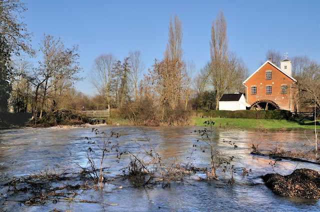
After a December with a reasonable amount of snow, it was to be expected that in January when the temperature rose a bit, the floods would come. Or at least a big rise in river levels. This year the rivers rose a lot, but peaked just short of flooding. Here in Layham, our little River Brett gave the opportunity of a few photos.


The mill pond at its highest I had seen, short of flooding.


... and looking back across the mill pond from the footbridge. 


I wonder why this is called Water Lane! Normally a narrow, but dry, lane in Layham. Even 30 mph is out of the question I think. This house, part of the old mill/granary complex, stands on blocks which normally keep it clear of the water. This time they have disappeared under! 


On the opposite side of the road, their tennis court is somewhere here! 


A normally shallow and placid stream nearby. 


Most of the year this is virtually dry but today it was taking the bulk of the Brett overflow past the mill and granary. And the noise!! Believe it or not, there are several steps under this deluge. 


Normally a very pleasant view of the river and meadows. 


Just outside the village the Brett changes course for a day or two. Not the best grazing area at the moment. 

Monday, 14 February 2011

Crocus and Snowdrops - Spring is here!

After the cold of Winter it is always a heartwarming sight to see the first signs of spring. A visit to the Castle grounds in Colchester provided a perfect opportunity to see Crocus in their glory. Well worth a look.


Crocus in the Colchester Castle Park


Close up of some of these glorious little flowers. 


Then, to see a great display of Snowdrops, a visit to another castle, this time Hedingham. Open every year for this beautiful display 


Some closer images of the Snowdrops. 


Spring would not be complete without Catkins! This display was in Lackford Lakes, north of Bury St Edmunds. 


Beside numerous other buds appearing in the hedgerow, there were plenty of Horse Chestnut buds to be seen. It just lifts the spirits to see winter retreating and Spring and Summer just round the corner! 


Then, of course, there are Daffodils. Always a Spring favourite.


Forsythia in full bloom


Cherry Plum (Nigra)


Early visitor to the Blackthorn


A mass of Blackthorn 


Cherry Plum, an annual display we all love to see. So, a great start to 2011, here's to looking forward! 


What we saw in Walton

One of our favourite seasides is Walton On The Naze, and it was to Walton, as is generally known, that we decided to spend the day. It's surprising what you can see when you are not in a hurry, and having a camera and photographs in mind. A good starting point is at the landmark point of the Naze Tower. 
The Hanoverian tower, more commonly known as the Naze Tower, is situated at the start of the open area of the Naze. It was a navigational tower, constructed to assist ships on this otherwise fairly feature-less coast. Visitors can climb the 111-step spiral staircase to the top of the 86-foot (26 m) tower for a 360 degree view of the beach and countryside. The Naze Tower features a museum with exhibits about the tower, the ecology and geology of the Naze, and the coastal erosion problem. The tower also features a private art gallery on six floors with changing exhibits several times a year, and a tea room. 


The present tower was built in 1720–21 by Trinity House, and was intended to work in conjunction with Walton Hall Tower to guide vessels through the Goldmer Gap. Towers at Naze and at Walton Hall are marked on a map of 1673 by Richard Blome, which in turn was based on a map drawn up in the late 1500s. The present Naze Tower therefore replaced an earlier construction at a similar location. It was of particular benefit to ships using the nearby port of Harwich. Both the current Naze Tower and its predecessor had beacons or lamps lit at the top, providing an early form of lighthouse. 
Over the years, the tower has had a variety of uses. In the eighteenth century it was a tea house, operated by the actress and aristocrats' mistress, Martha Reay. It was a lookout during the Napoleonic Wars and again during the Great War of 1914–18. In the Second World War it was used as a radar station, with its crenellations removed to accommodate a radar dish. 


Another view of the tower, this time from the beach below the cliffs. It's beginning to look rather precarious, however, looks are deceptive as it is someway back from the edge still.


As these later images show, the Walton cliffs are eroding at an alarming rate - as is a lot of the Suffolk and Norfolk coast line.


Walking back toward the town, I noticed this dog peering down at us. I did think he would scramble down at one point but it didn`t.


Not sure what the man was doing, if anything, but the gulls were very active overhead.


Green symmetry.


How a long focus lens alters the perspective. They are close, but not quite as the image would suggest.


More symmetry or repetition.


Gulls swooping around this couple enjoying their lunch


Five in a row - and all facing the same way!


Yet more symmetry under the pier - watch the tide!