Posts

A view of Chester - Part 2 of 2

Image
On our wander around Chester, not only the buildings were interesting, but also the people. Suddenly spotted this elderly lady with her elderly camera, standing in front to me, photographing something. Just had to take a picture of her! We had a conversation for a few minutes, and it turned out that she had several other old cameras in a carrier back in her hand! The Old Photographer A bronze sculpture of a Elephant, unveiled on Tuesday 16th March 2010 opposite the Town Hall. It is called Janya, and is a baby Indian Asian calf. It was donated by Chester zoo. Next we moved onto Chester Cathedral. The C7th Mercian King, Wulfhere, is reputed to have founded a timber church on this site dedicated to St Peter and St Paul, but it was his daughter, Werburgh, who really put Chester on the map. She renounced her royal status to become a nun at Ely Abbey. Many miracles were attributed to her during her lifetime, including restoring back to life a goose that had been stolen an

A view of Chester - Part 1 of 2

Image
One of the first places we passed on our way to Chester town centre, was some Roman remains. The History of Chester can be dated back to the Romans who named Chester Deva (pronounced Dewa) after the spirit of the River Dee. Roman Chester was considered as important then as Londinium (London). The Romans didn't just create a small fort here, they meant to stay, building a city for their 20th Legion. The Romans built Chester as a strategic position at the centre of Roman Britain, with plans to sail from the River Dee to invade Ireland and North Wales.  In the Roman gardens Part of the Chester Roman Amphitheatre - the largest amphitheatre to be found in Britain. The Chester Roman Amphitheatre, was built to serve the fort of Deva. It was used as a multi-purpose entertainment centre for the troops stationed here, and also as a training ground. Installed in 1899, the Eastgate Clock is positioned on the bridge over Eastgate Street in the city of Chester, the

The Pontcysyllte Aqueduct

Image
The start of our short break!  First a family visit, and then onto the Pontcysyllte Aqueduct. The pictures and write-up sounded good. so we were looking forward to seeing it. Approaching our destination, we stopped for a while to admire the river Dee as it flowed through the town. Noisily (above) and peacefully (below). And then our first sight of our objective. Designed and built by Thomas Telford and Williams Jessop, Pontcysyllte means 'the bridge that connects', a magnet for those who want to experience one of the most remarkable achievements of the industrial revolution. You can walk across Pontcysyllte, or save your legs and take a leisurely boat ride - we did neither! Well, we did walk underneath and along the path to the edge of the bridge. The Pontcysyllte Aqueduct is a navigable aqueduct that carries the Llangollen Canal across the River Dee in the Vale of Llangollen in north east Wales. The 18-arched stone and cast iron structure is for u

The Tithe War

Image
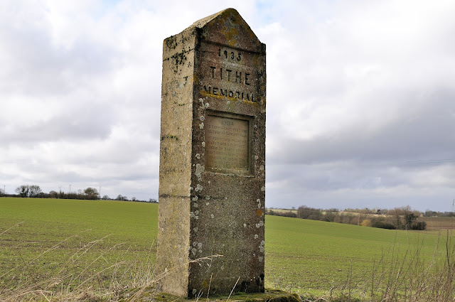
The Elmsett tithe memorial is one of several reminders in Suffolk of the battle fought by small farmers against the demands from the Church for payment of tithes. It also recalls a now largely forgotten but rather murky period in East Anglian local politics.  In the 1930s, agriculture in England experienced a deep depression, and it was very hard to make the land pay. The Church of England had undergone much modernisation over the previous century, but even so, there were still parishes where the tithe system meant that even small landowners were legally obliged to contribute a proportion of their income to the church for the upkeep of its incumbent. This was the case even if they were not Anglicans, which in Suffolk many were not. In addition, many of the smaller landowners were supporters of the Liberal Party, but the governing Conservative Party, which many of the larger landowners supported, stood foursquare behind the Church in the matter. If the landowners refused to pay, t

Framlingham and Orford castles

Image
Framlingham Castle is an externally perfect moated 12th century castle. The fortress consists of a curtain wall punctuated by 13 square towers. The curtain wall has remained in an exceptional state of preservation despite the castle's advanced age, and the renovations of later centuries, which saw it used as a school, a poorhouse, and a prison.! Now for some history (courtesy of Wikipedia): The site was probably used for fortifications as early as the 6th century, but of those early structures nothing remains. Framlingham enters history more firmly at the turn of the 12th century when the estate was given by Henry I to Roger Bigod. It seems likely that Bigod built a simple wooden motte and bailey castle at Framlingham, but it was left to his second son, Hugh, later the first Earl of Norfolk, to replace that structure with one of stone. That fortification was ordered dismantled by Henry II about 1175, but it was rebuilt by Hugh's son Roger, the Second Earl of Norfo

Cold and Frosty start to 2010

Image
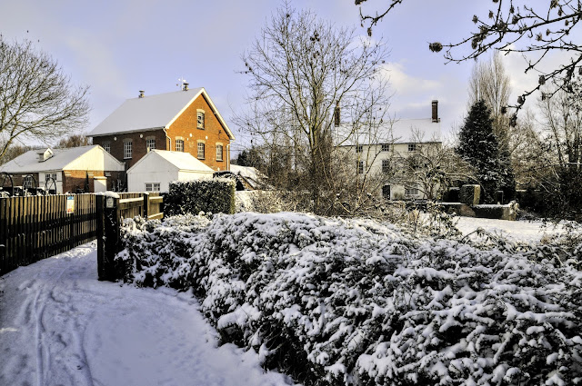
The start of 2010 was cold and snowy! It is a different world around you when it is covered in snow, and as long as the sun is out, there can be some great photos to be had. That is assuming you can stay upright on your walks! So, not far from home, and on my usual walking trail, my first image is of the old mill and mill house. Then onto St Andrews Church. One lone tree against a blue sky and white fields. Obviously not `clear` of snow! Looking back toward the church, and do I detect an attempt to sand the lane? Looking across the Hadleigh Cricket ground. Not playing today then? Bird tracks on the frozen waterways. I wonder what they make out of all the ice on their water? And the cows looking for green - it was here yesterday!   Home