Sunday, 2 February 2014

What can be seen at Walton on the Naze?

Walton is a traditional seaside town on the east coast, unique in that it is surrounded on three sides by the sea. Its three miles of gently shelving sandy beaches facing south-east stretch from Frinton to the Naze. To the north, the sea sweeps round the Naze into the backwaters, known as Hamford Water, and the Walton Channel stretches right down to Walton Mere, only 300 yards from the main beach. The Naze, as well as being a natural open space, is a Site of Special Scientific Interest (SSSI) famed for its fossils found in the Red Crag cliffs.
As well as these glorious natural features, Walton is known for its pier – the second-longest in the country – its yacht club and marina, and its iconic tower at The Naze from where panoramic views can be enjoyed of the Walton backwaters, Harwich and Felixstowe and the Suffolk coast. 


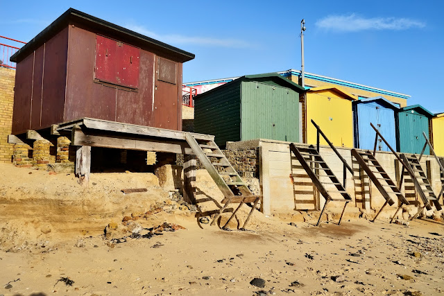
The coast of East Anglia is always subject to erosion and the day of our visit to Walton demonstrated the effects which a stormy period on the North sea can have on the area 
These beach huts would normally have a bit more sand in front, but it has been washed away leaving a nasty gap between bottom step and the beach! 


Another view of an area normally deep in sand. 


One has to wonder haw many years before the famous tower is in danger? Built in 1720 by Trinity House as a navigational aid for ships making for Harwich Harbour – is now an art gallery and tea rooms 


More of the cliff has slid toward the sea


Somehow, there is always an odd shoe.


.... or a glove! 


So to some wildlife. In a row - shame about the empty end posts! 


Sanderling seen on the beach 


What are you doing down there? 


Three is a crowd. 


These swirls are the “castings” of a worm. Various species of lugworms are found in sandy marine mud all over the world. They ingest the sandy mud at one end, and excrete digested sand at the other. They can process a cubic centimeter or more of sand every hour. The worms digest the bacteria and other microorganism in the sand, in much the same way that earthworms process soil. So, some images of worm poo! 


Patterns in the sand 


The colour green. Seaweed coating the steps to the beach.


Under the pier. A view toward the sea as the tide retreats


Colours


Gulls inviting themselves to lunch 


The remains of a WW2 pillbox on the beach. The Walton of today is a somewhat different place to that of WW2 due to it`s proximity to the entrance to Harwich . A good taster of how the area was in that period can be found here.


Friday, 10 January 2014

A winters day in January

We expect to have January as a cold, sometimes snowy, month. There are things to photograph which are interesting, and often just eye catching, such as these cobwebs in fences and railings. 


Cobwebs adorn the railings and nearby fences 


The first showing of snowdrops on the roadside 


Believe it or not, these Velvet Shank Fungi (Flammulina velutipes), spotted on a nearby tree. 


And an image of a tree in the mist. First image in the mist, second one on a sunny day with a NIk Effex filter applied. 


Home    Forward   Back

Wednesday, 20 November 2013

Dalby Forest and the Bride Stones

Not too far from Pickering is Dalby Forest and the Bride Stones. Today this was our destination, a walk in the forest. It is on the southern slopes of the North Yorkshire National Park. It was a glorious day - we have been so lucky at it is November!


A memorial to the "lumberjills" - the women who worked in forestry during World War Two


As we entered the forest we saw this sculpture, so we had to investigate! Later, a little investigation revealed its origins:
The sculpture is a steel fabrication of a felled tree and two lumberjills. Some 9,000 British women were recruited to work in forestry during the war. 
The lumberjills carried out heavy work, felling trees by hand, working in sawmills, loading trucks and driving tractors.
The timber was made into telegraph poles, road blocks, packaging boxes and gun butts for the war effort, and even crosses for war graves.
Sculptor Ray Lonsdale won the Forestry Commission competition to create a lasting memorial to honour the women.
The sculpture on Haygate Bank in Dalby, called Pull Don't Push, is five metres long and three metres high. The Forestry Commission said the sculpture "captures the arduous nature of the work as well as the fun lumberjills had working in the forests during the war."


As it was November, the forest was full of late autumn colours.Leaves in many shades and of course the forest floor of bracken.


The Bridestones. 


Aptly named ‘Brink-stones’ or edge stones in Old Norse, you can follow footpaths to the top to experience the Bridestones first hand. These fascinating rocks are the remains of a sandstone ‘cap’ that was originally much higher, Jurassic sedimentary rock deposited some 150 million years ago.
Layers of hard sandstone alternating with softer calcareous layers have been eroded by wind, frost and rain over thousands of years. The result is the strange and wonderful shapes left today. 


What is this? Well, one of my interests, especially when in new places, is Geocaching. If you are unfamiliar with the term, follow this link
In this area was a cache I was trying to find, and realised from the clue that it was probable disguised. Suddenly, on a pile of logs I spotted a log with a screw in the end. On investigating, the top of the log rotated on the screw revealing the log book. Very crafty! 


The surrounding nature reserve is a high, wild and inspiring blend of open heather, rough pasture, wooded hillsides and stunning summer-flower filled grassy dales. It is a designated Site of Special Scientific Interest (SSSI), so sensitive management is very important. On the open moor new tree growth is controlled and you might see cattle which are grazed to stop the land returning to the woodland it once was.
Bridestones Griff separates the two groups of stones, leading to the grassy valley of Dovedale and its ancient woodland. It’s the perfect place to enjoy wildflowers, butterflies and birds at the edge of a rippling beck, although when we visited it was just autumn colours.


The view from Sutton Bank on the way home to our holiday cottage.

Sutton Bank is a hill in the Hambleton District of the North York Moors National Park, North Yorkshire in England. It is a high point on the Hambleton Hills with extensive views over the Vale of York and the Vale of Mowbray.
At the foot of Sutton Bank lies the village of Sutton-under-Whitestonecliffe; at 27 letters long, it has the longest hyphenated placename in England.
The A170 road runs down the bank with a maximum gradient of 1 in 4 (25%), and including a hairpin bend. Vehicles have to keep in low gear whilst travelling up or down the bank, and caravans are banned from using the section. 
After our first ascent, we relaxed on subsequent trips to the top! We walked from the Sutton Bank National Park Centre at the top to a point where we could watch the gliders taking off from the Yorkshire Gliding Club.


Another view from the top of Sutton Bank


Green phone box - Fangdale Beck, North Yorkshire.The unusual colour was by special agreement with the local landowner. 
Apparently a story circulating has this info: "It was my late father, Fred Jackson, who was responsible for the green phone box. He worked at the then Telephone Managers Office in Middlesbrough as a sales executive and was responsible for most of the selling of phones to the Dales farmers of the area during the late 1940's and early 50's. 
He hated the thought of a red kiosk in such a stunning area and worked very hard - obviously with the local landowner, to achieve the green box."
Is it true? - who knows!, but it was worth seeing.


Next morning was time to head home and we were greeted by this glorious sunrise for our last morning.

Home    Forward     Back

Tuesday, 19 November 2013

Malham Cove and Janets Foss

When visiting the yorkshire Dales, one of the `must see` places is Malham Cove. It is a spectacular 80 metre high limestone cliff and is one of the most popular natural features to be found in the Yorkshire Dales. This our destination for the day.
We parked in the village of Malham, and set out to walk to Janet's Foss, a small waterfall which carries Gordale Beck over a limestone outcrop topped by tufa into a deep pool below.


Lone tree on our route to Janet's Foss


The pool was traditionally used for sheep dipping, an event which took on a carnival air and drew the village inhabitants for the social occasion.
The name Janet (sometimes Jennet) is believed to refer to a fairy queen held to inhabit a cave at the rear of the fall. Foss is a Nordic word for waterfall, still used in Scandinavia, and is presented in a number of cases in England as 'force'.


From Janet's Foss we walked along a fairly well used pathway until we were in sight of the top of Malham Cove.


Looking toward the Cove from the side


The view from near the top toward the river and the road - it's a big drop.


You wouldn't run around on this Limestone pavement!

Now for the technical bit: 
A limestone pavement is a flat expanse of exposed limestone formed by a combination of chemical weathering and erosion. Limestone pavements in England, Wales and Ireland are mainly formed on Carboniferous limestone 
Clints (sometimes called by their German name, flachkarren) are the blocks of limestone that form the pavement. They are chemically weathered so that their surface is covered by a series of pits and hollows (called karren).
Grykes are fissures separating the Clints in a limestone pavement. They may be well over a metre in depth, and formed when the joints in the limestone were widened by chemical weathering.
End of class!


The cove was formed thousands of years ago by a large Ice Age river that once flowed down the (now dry) valley above the cove. It then plunged over the lip of the cove in what would have been the most spectacular waterfall in the country. Only after severe amounts of rain, such as after Storm Desmond in 2015, does Malham Cove temporarily turn back into a waterfall.
While the sheer height of Malham Cove is perhaps its most impressive feature it is also famous for its limestone pavement above. While care needs to be taken to negotiate its clints and grikes a walk across the limestone pavement is not to be missed.
This natural limestone formation in the Dales appears in Harry Potter and the Deathly Hallows Part One, in a nail-biting scene when Harry and Hermione hide from Lord Voldemort in a rocky camp.
It is a spectacular sight, I just would like to see the waterfall.


Home    Forward     Back

Sunday, 17 November 2013

Gillamoor and Lastingham - The Moors

Today was another exploring day through the village of Gillamoor and onto Lastingham. Not sure what we will see but as we have time on our hands ,and a full tank of petrol, off we go!


Gillamoor is a village and civil parish in the Ryedale district of the county of North Yorkshire. It is situated about three miles north of Kirkbymoorside on the edge of the North York Moors National Park. 
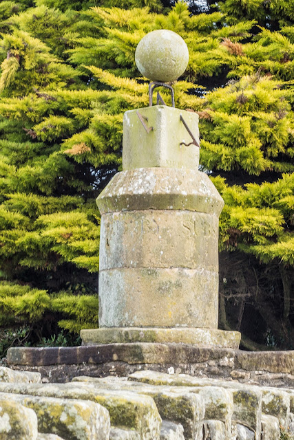
Once there, the first thing to catch our eye was this sundial. An unusual, complex, four-faced sundial (pictured above) surmounted by a finely carved stone globe, a Grade II listed structure. It stands by the roadside in the centre of Gillamoor. It was erected August 27th 1800 by John Russell by public subscription


The small attractive village church of St. Aidan stands right on the edge of a moorland escarpment, dropping sharply for 150 feet to the River Dove and the southern entrance to Farndale. It was rebuilt single-handedly in 1802 by local stonemason James Smith of Farndale using stone from the dismantled medieval church in Bransdale. The building was restored in 1880, and furnished by Temple Moore in 1908.
A church has occupied the site since as far back as the twelfth century. The present church consists of a simple rectangular structure with a nave and chancel and a porch at the western end of the south wall and an attractive bellcote at the western end of the building. The church is windowless on the north and west sides, reckoned a necessary safeguard against the prevailing winds.


View from the village toward the moors before we drove onward toward Lastingham and a brief look at the church


Simon Jenkins, author of England's Thousand Best Churches, calls the Norman crypt of St Mary's church in Lastingham 'one of England's special places'. It is certainly amazing that it has existed for so long and just standing there and thinking of the generations of people who have knelt here, it is awe inspiring!


Around AD 725 the first stone church was built on this site n 1228 the former monastic church became the parish church for Lastingham village. A north aisle was added, followed by a south aisle in the 14th century, and a west tower was added in the 15th century. The church was in poor condition by the 17th century, until it was rebuilt by Thomas Ferres, a native of Lastingham who rose to become Mayor of Hull.
One interesting footnote in the history of Lastingham church comes from the 18th century when a curate named Jeremiah Carter was employed by an absentee vicar. Carter was married, with 13 children to support, so he supplemented his family income by fishing, while his wife kept the local Blacksmith's Arms pub. 
Carter was known to play the violin to entertain visitors to the pub. When questioned by the archdeacon on the propriety of his actions, Carter replied that his parishioners enjoyed three advantages, being instructed in religion, fed and entertained all at once. He argued that this method spending the Sabbath was so agreeable that his charges were 'imperceptibly led along the paths of piety and morality...'
Interior highlights include a 12th century font, a medieval floriated grave slab, and a free-standing 15th century water stoup.
The main attraction for many people is the Norman Crypt.


And so onto Lunch which was greatly enjoyed at the Moors Inn. The Moors Inn has been trading as an inn since the 17th Century in the beautiful village of Appleton- Le Moors.


Home    Forward     Back