Monday, 11 June 2018

Birds of Bempton and Flamborough Head

We had wanted to return to Bempton Cliffs in Yorkshire since our previous short visit. So a few days in the area seemed a good idea and Bridlington it was! 
We had not had a look at the fishing port of Bridlington, so we were `killing two birds with one stone`, as was often said.
We were booked into the Lobster Pot Inn only about 20 min drive from Bempton Cliffs, and this was our first port of call.
The Bempton Cliffs reserve, on the spectacular Yorkshire coast, is home to one of the UK's top wildlife spectacles. Around half a million seabirds gather here between March and October to raise a family on towering chalk cliffs which overlook the North Sea. Read more at RSPB
The experience is truly awe inspiring at this time of year and we could recommend this as a must if you are in the area. So to a few images of the birds swooping and diving in front of us! 


An adult Gannett


Kittiwake


Juvenile Gannet of between 2 and 3 years old, according to the wing pattern.


Razorbill viewing the scenery or protecting his space more likely!


The iconic Puffin - not so many here as there are of the bigger birds.


Who are you staring at then? - Jackdaw waiting for my sandwich

As we intended to return here the next day and spend more time, we drove a few miles south to another popular and spectacular place - Flamborough Headland.
As well as a great coastline, Flamborough has two lighthouses, one of which is still in use - and a great tea room nearby.


 Flamborough Coastline


The `New` Lighthouse 

A lighthouse was first built on the Flamborough Headland in 1669 but was never lit. The current `new` lighthouse was built in 1806 and acts as a waypoint for deep sea vessels and coastal traffic as well as marking the Flamborough Headland for vessels heading for the ports of Scarborough and Bridlington. 


The old chalk tower is set a short distance back from the sea, the 'new' one is built on the cliff edge. The chalk tower is the only surviving light tower in England. It was designed for a brushwood fire to have been burnt on top, although it is unknown whether or not it was ever lit. The octagonal tower has several windows and a ground floor fireplace so it was possible lived in. I don`t think I would have wanted to be the Keeper. 
It was 130 years before a lighthouse was built on Flamborough. The 'new' lighthouse was built after over 170 ships had been wrecked off the headland in 36 years. In 1925 it was made taller to fit a new 15 foot lens and converted from oil to electricity in 1940. 
It has a range of 24 nautical miles and is one of only 72 lighthouses still in use around Britain's coast today. Now it is fully automated. 


The coast near Flamborough


So, another trip to Bempton, and more bird photos. Just all minding their own business.


I love this bird, the Razorbill.


Kittiwake


Just checking out the burrow after a time at sea.


In love, while the neighbours watch! It was quite touching to see their bonding behaviour.


A study of a Jackdaw - again waiting for lunch.


Juvenile Gannet probably only one year old as he is still mostly black.


Filey Brigg is a long narrow peninsula situated about a mile north of Filey, North Yorkshire.

Its steep cliffs are 15 metres high and consist of a variety of material, from pure sandstone to pure limestone. The landward end of the peninsula of Filey Brigg is known as Carr Naze, whilst the long neck of rock at the seaward end is called the Brigg. 

Close to the cliff edge at Carr Naze (Filey Brigg) at the north-eastern side of Filey and near to the Country Park is the “site of” some faint rectangular earthworks of Filey Roman Signal Station. This was the southernmost signal station of five along the Yorkshire coast, and was in use from roughly 375-410 AD; it was manned by a small garrison of soldiers, with the rocky ‘spittal’ (mooring place) below the cliffs being used as a natural harbour for Roman sailing vessels. Filey’s Roman signal station, along with the four others, would have formed a defense against attacks by sea-borne invaders from across the north sea. The beacon on top of the tower would be lit when invading ships were spotted on the horizon, acting as a warning to the other stations along the coast so that evasive action could be taken. In a recent landslip part of the earthwork (two thirds) at the eastern edge disappeared over the cliff and the rest of the site is in ever constant danger of going the same way.

We walked from the lovely Country Park out along to the end of the Brigg and back to find I had forgotten to pay to park! Oh dear! - that was an expensive (£25) visit.


This way mark grabbed our attention as it is somewhat different. It marks the coastal path - The Cleveland Way.


The Flamborough coast at sunset.


.... and with the tide at a low ebb.

Tuesday, 29 May 2018

The Anglo-Saxon Village at West Stow

The Anglo-Saxon Village at West Stow is both a living museum and an archaeological site, surrounded by a popular country park. Some time around AD 450 a small settlement grew up at West Stow, on the banks of the River Lark. The village was built on a low hill, now overwhelmed by a sand dune.
The settlement lasted until about AD 600 and evidence has been uncovered for around 70 buildings on the site. These buildings have described as 'sunken-featured', a style formerly known as pit houses. At its height there were at least 8 timber halls and over 60 other buildings.
In 1849 an Anglo-Saxon cemetery was uncovered, and archaeologists began to explore the area. They found evidence of habitation as early as the Mesolithic period, but the major finds related to the Anglo-Saxon settlement. Aside from the timber halls, archaeologists discovered animal pens, pits, and boundary ditches. There was no sign of a fortification of any kind, suggesting that the inhabitants felt safe from attack.


The view of the village as you approach it. One of England’s great archaeological sites, West Stow has extensive indoor galleries and a stunning recreation of an Anglo-Saxon village surrounded by 125 acres of unspoilt countryside.
In 1976 the West Stow Anglo-Saxon Village Trust was formally established to manage the site, at that stage there were three reconstructed houses within the village. The reconstructed village now consists of eight buildings: craft building, farmers house, hall building, living house, oldest house, sunken house, weaving house, workshop. Some of these are shown below in the images that follow.


The Sunken House


The oldest house


The Weavers House


The Hall


The Living House


The Workshop

The layout of all but one of the halls was on an east-west axis. Most halls were simple rectangular buildings, but one, dubbed Hall No. 2, had an internal division and was supported o double posts along its length. The most clearly defined hut remains showed evidence of a doorway in both the north and south walls. There was no hearth, but evidence of burnt sand was discovered in the centre of the hut.
Several Roman bronze coins were found on the site, as well as brooches, a bone comb, and Roman glass pieces.
The truly fascinating thing about the West Stow site, and the thing makes it so intriguing to visit today, is what the archaeologists did after they had investigated the Saxon remains. From 1977 they embarked on an ongoing project of recreating the huts they had discovered, using Anglo-Saxon hand tools and building techniques. They wanted to learn more about Anglo-Saxon architecture, and discover if they could, how and why buildings were constructed. This kind of experimental archaeology goes beyond simply recording historical artefacts, and also helps educate visitors about the Anglo-Saxon period.

Each of the reconstructed huts takes a slightly different approach, using different material, to see what materials work best and what techniques make for a longer lasting building. The Anglo-Saxons built in timber, so their buildings did not last. Archaeologists can use experiments like the West Stow Village to understand what kind of building techniques would account for the remains they excavate, and hope to learn more about how the people of West Stow lived.
Each of the huts is slightly different inside as well. The weaving House, built in 1984, is filled with hand-weaving looms and tools. The Living House, made in 1987, is furnished as a dwelling. Then there is a Workshop, laid out for woodworking. One of the huts is sunken well into the ground, while others have a plank floor raised up off the soil.
Even the pig huts are made with traditional Saxon techniques. There are several demonstration areas where you can see examples of traditional crafts such as woodturning on a foot-powered lathe.
The modern visitor centre holds a museum of artefacts, and is where you can watch a video on the archaeology of the site.


Thursday, 24 May 2018

The cathedral city of Canterbury

We were hoping that today's rain would not be too heavy as we planned a trip to Canterbury to visit the cathedral primarily, but anything else in the town that took our interest.This was a place we had not visited before. Before we left for our visit,Mr fox was spotted again jogging through the field at the back of the property. 
And so, via a convenient Park And Ride, we arrived in the center of Canterbury. 
Not many photographs taken on the outside as the main west end was covered in scaffolding but just a few for the record!


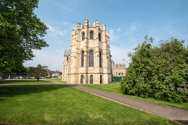
St Augustine, the first Archbishop of Canterbury, arrived on the coast of Kent as a missionary to England in 597 AD. He came from Rome, sent by Pope Gregory the Great. It is said that Gregory had been struck by the beauty of Angle slaves he saw for sale in the city market and despatched Augustine and some monks to convert them to Christianity. Augustine was given a church at Canterbury (St Martin’s, after St Martin of Tours, still standing today) by the local King, Ethelbert whose Queen, Bertha, a French Princess, was already a Christian.This building had been a place of worship during the Roman occupation of Britain and is the oldest church in England still in use. Augustine had been consecrated a bishop in France and was later made an archbishop by the Pope. He established his seat within the Roman city walls (the word cathedral is derived from the the Latin word for a chair ‘cathedra’, which is itself taken from the Greek ‘kathedra’ meaning seat.) and built the first cathedral there, becoming the first Archbishop of Canterbury. 
Until the 10th century, the Cathedral community lived as the household of the Archbishop. During the 10th century, it became a formal community of Benedictine monks, which continued until the monastery was dissolved by King Henry VIII in 1540. Augustine’s original building lies beneath the floor of the Nave – it was extensively rebuilt and enlarged by the Saxons, and the Cathedral was rebuilt completely by the Normans in 1070 following a major fire. There have been many additions to the building over the last nine hundred years, but parts of the Quire and some of the windows and their stained glass date from the 12th century. By 1077, Archbishop Lanfranc had rebuilt it as a Norman church, described as “nearly perfect”. A staircase and parts of the North Wall – in the area of the North West transept also called the Martyrdom – remain from that building. 
After the Restoration in 1660, several years were spent in repairing the building. In the early 19th Century, the North West tower was found to be dangerous, and, although it dated from Lanfranc’s time, it was demolished in the early 1830s and replaced by a copy of the South West tower, thus giving a symmetrical appearance to the west end of the Cathedral. During the Second World War, the Precincts were heavily damaged by enemy action and the Cathedral’s Library was destroyed. Thankfully, the Cathedral itself was not seriously harmed, due to the bravery of the team of fire watchers, who patrolled the roofs and dealt with the incendiary bombs dropped by enemy bombers. 
This a magnificent building, and fills you with awe as you gaze at the workmanship, and marvel at the vision that these people had who designed and built it. Whatever your faith, or none, this stirs the senses that few buildings do.  


Son Of Man - Completed in 1988 and dedicated that year by Archbishop Robert Runcie, it stands over 7 feet high and is cast in bronze. It was created by David McFall who died of cancer shortly before the dedication took place. The figure was originally submitted as a candidate for the competition to fill the vacant niche on the Christ Church gate. This was won by Klaus Ringwald but the McFall statue was admired and thought suitable for its present site. The large hands on the Son of Man figure were designed to be viewed high on the gate - the optical distortion in this position would make them look more balanced. 


The east end of the cathedral was rebuilt in 1174-75 in a pioneering and highly influential Gothic style.


The pulpitum screen of the 1450s divides the nave from the quire. It features sculptures of six English kings.


The Quire, focus of music and worship to this day, was the first part of the east end to be rebuilt. 


The Pilgrims Boat, part of a series of installations by international artists Philip Baldwin and Monica Guggisberg reflecting on themes of war and remembrance, migration and refugees - Commemorating the 100th anniversary of the end of the First World War 


As visitors move around the Cathedral, they will come across a series of ten installations that begins with 100 glass amphorae suspended in the shape of a ship in the Cathedral’s Nave, each one representing one year since the end of the First World War. In the Martyrdom, four pieces blown at a workshop in Venice represent the four assassins of Thomas Becket, while in the North Aisle a glass boat filled with spent shells, grenades and other debris together with sheets of statistics ignite conversations about the plight of refugees in war, migration and “collateral damage”. The artists worked with the Cathedral Stonemasons to create The Stone Boat in St Anselm’s Chapel. In the Eastern Crypt is a triptych displaying the past, present and future, and the exhibition ends in the Chapter House with a wall of coloured glass, celebrating all of human diversity. 


The Martyrdom - Thomas Becket was born in around 1120, the son of a prosperous London merchant. He was well educated and quickly became an agent to Theobald, Archbishop of Canterbury, who sent him on several missions to Rome. Becket's talents were noticed by Henry II, who made him his chancellor and the two became close friends. When Theobald died in 1161, Henry made Becket archbishop. Becket transformed himself from a pleasure-loving courtier into a serious, simply-dressed cleric. 
The king and his archbishop's friendship was put under strain when it became clear that Becket would now stand up for the church in its disagreements with the king. In 1164, realising the extent of Henry's displeasure, Becket fled into exile in France, and remained in exile for several years. He returned in 1170. 
On the 29 December 1170, four knights, believing the king wanted Becket out of the way, confronted and murdered Becket in Canterbury Cathedral. 
Becket was made a saint in 1173 when miracles were said to take place, and his shrine in Canterbury became one of Europe’s most important pilgrimage centres. A real money making machine! The murder took place in what is now known as The Martyrdom. 


The Font was installed in 1639 for public baptisms. It was smashed up a few years later by Puritan soldiers, but the broken pieces were collected and hidden until 1663 when it was re-installed. A drawing found on a market stall in 2002 proved to be the design of the font. 
The font stands on a marble plinth, with white marble figures of the four Evangelists around the stem. The cover has small statues of the 12 Apostles, coats of arms and a figure of Christ blessing children at the top. 
A pulley allows the blue and white gilded cover to be raised and lowered. The carved dove at the base of the cover represents the Holy Spirit. 


The ornate wooden pulpit standing at the east end of the nave was erected in 1898 in memory of Dean Robert Payne-Smith (Dean from 1871 to 1895). It was carved by the architect George Bodley. The main panels include carvings of the crucifixion and annunciation. The balustrades carry two large figures, according to modern writers those of St Augustine of Canterbury and Pope Gregory. Not all agree, however - J Charles Cox writing in 1905, not long after installation of the pulpit, claimed the figures represented St Augustine and St Paulinus. Brass plaques by the pulpit stairs refer to the Dean and to his daughter, Jessie, a scholar of the Syriac language. 


John Wastell`s glorious fan vault, completed in 1503. Difficult to photograph in all its splendour. 


Ceiling bosses in the Great Cloisters mostly represent the donors who funded its construction. 


The Great Cloister used by the monks when the building was the church of the Benedictine priory of Christ Church 


The Christ Church entrance - Cathedral records indicate the gate was built between 1504 and 1521 with funds provided by Priors Goldstone and Goldwell. This is despite the inscription of 1507 on the stonework “Hoc Opus constructum est anno Domini millesimo Quingentesimo decimo septimo,” - a matter of ongoing dispute between historians. It was probably built in honour of Prince Arthur, Henry VIII's elder brother who married to Catherine of Aragon in 1501. He died the following year aged just 16, allowing Henry VIII to become King and marry Katherine himself in 1509. Imagine the consternation of the sculptors responsible for the heraldry trying to keep up with changing family dynamics! The original statue of Christ and the wooden gates were destroyed by the Puritan iconoclast Richard Culmer in 1643. The gates were restored by Archbishop Juxon in 1660 and still bear his arms. The statue of Christ was replaced in 1990 after a gap of 347 years. 
We did not pay to have our wander around the building and grounds. This was not intentional! We saw what we thought was the entrance, a shop with all the usual things you buy when visiting these places, entered, bought a guide book, and wandered into the grounds. It was only when leaving via the Christ Church entrance, and saw the people queing with their £12.50 in hand, that I realised our error!. Ah well! 
We wandered around the town center for a while and then had some lunch before visiting the Hospital of St Thomas the Martyr of Eastbridge. 


I just loved these seats (scooters) outside this Cafe. 


No city is complete without it`s buskers. They were good, Rolling Stones, when we passed by! 


Chaucer of Canterbury Tales fame. 


The Hospital of St Thomas the Martyr of Eastbridge was founded in the 12th century in Canterbury, England, to provide overnight accommodation for poor pilgrims to the shrine of St Thomas Becket. It is now one of the ten almshouses still providing accommodation for elderly citizens of Canterbury and is a grade I listed building. 
The hospital is situated on the King's-bridge, near the Westgate, in Canterbury. It was established sometime after the death of Thomas Becket (1170), possibly as early as 1176, when Canterbury Cathedral became a site of pilgrimage; the hospital provided accommodation for the pilgrims. The earliest name recorded as founder is that of Edward FitzOdbold c. 1190, with further endowments by Archbishop Hubert Walter about 1203. For many years, no special statutes were enacted, nor were any rules laid down for the treatment of pilgrims. 
In the fourteenth century the Hospital was reformed by Archbishop John de Stratford, during the reign of Edward III; he created ordinances, as well as a code of regulations to be acted on concerning pilgrims. He ruled that every pilgrim in health could rest in the lodgment for one night at the cost of four pence, that weak and infirm applicants were to be preferred to those with better health, and that women "upwards of forty" should attend to the bedding and administer medicines to the sick. He also appointed a Master in priest's orders, under whose guidance a secular chaplain served. Further lands and revenues from parishes were given by Stratford and by Archbishop Simon Sudbury (A man with some local connection) 


This institution survived the Dissolution of the Monasteries and other religious houses during the reigns of Henry VIII and Edward VI, although the pilgrimage to St Thomas of Canterbury did not survive this period. In 1569 Archbishop Matthew Parker issued new ordinances governing the Hospital and its Master which specified the maintenance of twelve beds for the 'wayfaring poor' and established a school in the chapel for twenty boys. This arrangement was confirmed by Archbishop John Whitgift by Act of Parliament in 1584. 
The school survived until 1879. The chapel was then little used until its restoration by the Master in 1927. Further restoration work has taken place during the twentieth century. Much of this work was financed by sale of some of the Hospital's lands at Blean at the foundation of the University of Kent in the 1960s: since the fourteenth century the Master of Eastbridge has been the Lord of the Manor of Blean. The Master is now also the rector of several of the amalgamated city parishes. Since 2003, the Hospital has been cared for by an Anglican Franciscan community. 


Westgate 


Canterbury was walled by the Romans around 300 AD. This has been consistently the most important of the city's gates as it is the London Road entrance and the main entrance from most of Kent. The present towers are a medieval replacement of the Roman west gate, rebuilt around 1380. There was a gate here at the time of the Norman conquest, which is thought to have been Roman. From late Anglo-Saxon times it had the Church of the Holy Cross on top, but both church and gate were dismantled in 1379, and the gate was rebuilt by Archbishop Simon Sudbury before he died in the Peasants' Revolt of 1381. It has been suggested that it was built primarily as an entrance for pilgrims visiting the shrine of St Thomas Becket at the cathedral. However the rebuild as a defensive status symbol was paid for partly by Sudbury and partly by taxation for military protection against expected raids by the French. 


Simon Of Sudbury, original name Simon Tybald, or Thebaud, or Theobald, (born, Sudbury, Suffolk, Eng.—died June 14, 1381, London), archbishop of Canterbury from 1375 and chancellor of England from 1380 who lost his life in the Peasants’ Revolt of 1381. 
A life-like model of the head of Simon of Sudbury is being gifted to the town’s museum this weekend, ahead of a public debate next week on whether the historical figure was a martyr or a monster. 
The bronze resin cast, crafted from Archbishop Simon’s semi-mummified skull, will be unveiled at the Sudbury Heritage Centre in the Town Hall on Saturday at 10.30am, after it was donated by former town mayor Tony Platt. 
The model is a twin to another cast in St Gregory’s Church, which has guarded Simon’s head for 600 years, after he was beheaded during the Peasants’ Revolt of 1381. 
David Burnett, secretary and trustee of the Sudbury Museum Trust, which runs the Heritage Centre, said: “We are pleased to have Tony Platt’s gift on show, because it helps to give a feeling for the real man, much more so than the grisly remains in a cupboard. 


Wednesday, 23 May 2018

Vikings at Sandwich and Pegwell Bay

A rather dull day today - which only got worse! Our destination was Sandwich and Pegwell Bay National Nature Reserve. We had a pleasant walk, saw few birds and the rain was beginning as we returned.


Whitethroat - my only bird of the day!


The Viking Ship Hugin on permanent display on the cliff top at Pegwell Bay, Ramsgate is a replica of a Viking ship which sailed from Denmark to Thanet in 1949 to celebrate the 1500th anniversary of the invasion of Britain, the traditional landing of Hengist and Horsa and the betrothal of Hengist's daughter, Rowena, to King Vortigen of Kent.
Out of 53 crewmen, only the navigator, Peter Jensen, was a professional seaman. Viking conditions were faithfully observed and the only instrument carried was a sextant. The 'Hugin' was offered as a gift to Ramsgate and Broadstairs by the Daily Mail in order to be preserved for posterity.
As there was no point in staying out, we returned via the shop and hoped for an evening walk if it cleared. We were in luck, the sun came out so a wander in the nearby woods above the cliffs. One thing made the walk as we started -a fox stopped and surveyed us for a few seconds, and then wandered away. Magic


Tuesday, 22 May 2018

Dover Castle and the White Cliffs

A short trip to Dover was today's plan. The castle and the WW2 underground tunnels being our main focus, followed by a visit to the National Trust site to get a photo or two of the White cliffs.

We parked our car, and ticket purchased, we made our way into the Castle area. It is breath taking in its scale and you can see why tourists flock here from abroad. Being near the ferry terminal might help! We spent several hours wandering around and reading and listening at the many information spots. 


The Medieval Colton Gateway of Dover Castle - The entrance though which Roman, Saxon and probably their Iron Age predecessors once entered their respective fortifications.


St Mary in Castro, or St Mary de Castro, is a church in the grounds of Dover Castle. It is a heavily restored Saxon structure, built next to a Roman lighthouse which became the church bell-tower. St Mary serves the local population and is the church of the Dover Garrison.
There are records of a church being built within the castle by Eadbald of Kent in the 630s. However, it is unclear whether this means within the Saxon burgh (usually dated to later than 630) on the Eastern Heights, or within the ruins of old Roman fortifications in the valley. The large, late-Saxon cemetery around the present church does suggest the existence of a c.600 church, but not definitively.

Next to the church is a ‘reasonably’ well-preserved Roman Lighthouse or Pharos, dating from around 46-50 AD (during the reign of the Emperor Claudius 41-54 AD) and, just after the invasion of Britain in 43 AD; the Roman army possibly first coming ashore here or further along the Kent coast at Walmer.
The Romans built a large fort here in c130 AD in order to guard the harbour and sea-route for the fleet sailing from Gaul and through the English Channel. It seems likely they rebuilt the fort in the mid 3rd century. They called the place Portus Dubris or Dubrae, which eventually became the Port of Dover. 


From a vantage point near the church, I took my first image of the imposing castle.


The Great Tower, which Henry II built, dominates the scene, and the history of this famous monarch made more sense when you actually stand among the remains of his grand edifice. The reconstructions, such as the kitchen, really brought alive the era. The whole castle appeared to be in the hands of the French today as bus loads of French school children swamped the area - how would Henry have dealt with that, I wondered.


King's Gate was built in the 1180s as part of the Inner Bailey walls surrounding the keep. The gate has an outer barbican for additional defence, with it's gateway positioned away from the main gate to limit a rushing attack - so I am led to believe!
As the closest part of England to the French coast, Dover was in a very important position in the WW2 struggle. Under the Castle area, tunnels had been constructed when we were expecting a Napoleonic invasion. As this never materialised, the tunnels fell into disrepair but were resurrected and expanded for use in the 1939 to 1945 war. We did two guided tours through the tunnels, one to the Hospital area, where we followed an audio and projected display of an operation to save a pilot who had been shot down and one to the operations area for Operation Dynamo:
Imagine working day and night deep inside Dover Castle's top secret tunnels as war raged outside, in a desperate bid to rescue the troops stranded at Dunkirk as German forces closed in.


This life or death battle against time was won in just ten short days in 1940, when Vice Admiral Bertram Ramsay pulled off a miracle. With no technology and with pitiful resources he masterminded the rescue of 338,000 troops from his Naval HQ in the tunnels below the castle. Vice Admiral Ramsay, is the unsung hero whose brilliant organisational skills pulled off the greatest rescue in our history - Operation Dynamo. The rescue from Dunkirk `tour` uses original newsreels and recordings, testimonies from veterans and dramatic special effects to recreate the terror and tension of these dark days of Second World War.
This was a very sobering tour, and is well worth a visit if you are anywhere near Dover.


The NT area on top of the cliffs, overlooking Dover harbour, has had an interesting history. It was first used as a holding area for convicts, then as a garrison for the military in Dover and then purchased by the NT in 1988, in whose capable hands it serves as the entrance to the Cliff top walks.
Above the current NT area, the cliff appears to have many zig zagged by paths. Apparently these are where railway tracks were laid, allowing materials to be moved in as the harbour was expanded.


It is difficult on a lovely sunny day to imagine the years of the war when this area was subject to ferocious shelling and bombing.
A gunnery duel, along with heavy German shelling and bombing of Dover strait and the Dover area, led to this stretch of the Channel being nicknamed Hellfire Corner and led to 3,059 alerts, 216 civilian deaths and damage to 10,056 premises in the Dover area. British coastal convoys had to pass through the bottleneck of the Dover strait to transport supplies, particularly coal; Britain's road and rail network was not then able to cope with the volume of traffic that had to be handled. Although the German guns regularly fired on these slow moving convoys from 1940 to 1944, with an interlude in 1943, they only sank two ships and damaged several others. Two seamen were killed and others were injured by shell splinters from near misses. However, the civilian crews of the merchant ships found the shelling more unnerving than the attacks by aircraft or E-boats that they were also subjected to and there were instances of crews refusing to sail from their forming-up point at Southend-on-Sea because of the German guns

A walk along the cliff top to a viewing point and a few photographs of the White cliffs, we made our way back to base for a well earned cuppa and rest!