Sunday, 11 September 2016

Beautiful Bude in North Cornwall

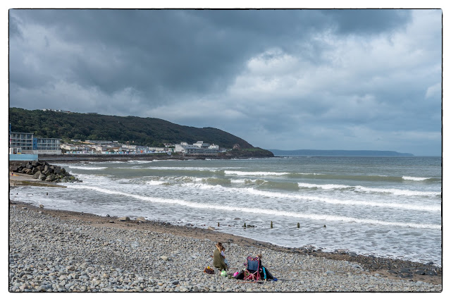
Day one of our holiday dawned with some cloud about, but a promise of sunshine. So today, a visit just along the coast to Bude, another place I have not visited.
Bude is Cornwall's most northern town and has been a popular seaside resort from Victorian times. In the l9th Century, the town was notorious for wreckers who plundered ship wrecked off the coast - over 80 vessels in the fifty year up to 1874. Not today, just tourists wrecking the place!


Bude has some good surfing beaches and was the site of the first life Saving Club. Today there were a few hardy souls trying to catch the waves. Mind you, I should be impressed by anyone who can surf, as I cannot even swim!


Next, some images of the beach huts. I just love the colours.


Watching the surfers, and anything else that moved, were these two Ravens. To quote the RSPB site "The raven is a big black bird, a member of the crow family. It is massive - the biggest member of the crow family. It is all black with a large bill, and long wings. In flight, it shows a diamond-shaped tail.
Ravens breed mainly in the west and north although they are currently expanding their range eastwards. Most birds are residents, though some birds - especially non-breeders and young birds - wander from their breeding areas but do not travel far."


Doggy paddle maybe?


I`ve got one!


Then a wander the cliff edge to see some of the interesting colours in the rocks.


What a holiday home this would be!


Then we wandered out to a rocky point which gave us a grandstand view of the whole beach and the waves crashing in the the other side. 


Gone for a swim.


We walked back along the beach to find a great place for coffee and cake and took time to photograph large numbers of geese which had stopped off, I suppose, for a rest before continuing migration to - who knows where?


Home    Forward     Back

Saturday, 10 September 2016

Crackington Haven

On leaving Bude we drove to Crackington Haven, the nearest bay to our holiday home. Apparently, many surfers tend to prefer the less popular beach of Crackington Haven and yes, they were there as well. And, no, I didn't get a photo!


Not a surfer, but Rosey checking her camera! In the background is Cornwall's highest cliff at 735 feet. There is Geocache at the top but my legs went weak at the thought!


More rock pools and colourful rock patterns. 

Some more history: 'Crackington' is a hybrid of Cornish and English 'Crack' means sandstone in Cornish and 'mutha tun' means river mouth farm in English. Located on part of the 600 mile South West Coast Path, Crackington is situated at the mouth of the picturesque valley which leads to Mineshop. It is of great geological importance with its carvoniferous rocks, which has even been given the name 'the Crackington Formation', for this reason the area has been designated a Site of Special Scientific Interest (SSSI), as well as an Area of Outstanding Natural Beauty. 
Crackington Haven was mainly used for the Quarrying of Slate. Large vessels would come in and beach themselves at mid tide, unload their cargo of limestone & coal, load up with slate taken from the cliffs and on the next high tide they would sail away. In the 19th Century plans were drawn up to build a harbour at Crackington, luckily these plans were abandoned leaving its unspoilt beauty relatively unchanged for centuries. 
Wrecks are said to have supplied much of the early building materials in Crackington. The rocky headlands claimed many boats all along the coast. If you walk around the rocks from Crackington Haven Beach off to the left, you may stumble across the last remaining parts of the WW2 S89 German E boat which broke tow whilst en route to Wales and washed up on Tremoutha Haven Beach on 5th October 1946. The engines are still visible and low tide for about three hours per day, please be careful not to get cut off by the tide. 
Crackington, along with Boscastle, suffered a great deal of damage in the flood of 16th August 2004. Shops, cafes and homes were flooded, cars washed out to sea, and the bridge suffered structural damage which has since been repaired. Crackington has never seen anything like it before. Seeing the peaceful village now, it is hard to believe that anything ever happened! The Cabin Cafe has a photo album showing the damage that occurred on that day, it is well worth a look. 


Just `round the corner` from Crackington Haven is the church of St Gennys, which is named after Saint Genesius. The church is built into a hillside, or so it seems! Note the sloping graveyard. 


... and is this the Priest's door? The door itself is very new. 

The cult of Genesius spread quickly from Arles into other parts of the empire, including Rome, where a titular church was built. It was then assumed that he was a Roman martyr: hence "Genesius of Rome". Later on, even more confusion helped to create an entirely fictional legend, in which he was a comedian who had converted to Christianity half-way through performing an anti-Christian satire, and was then beheaded. This latter story began in the 6th century at the latest. 
Having wondered who this Saint was, I checked with Wikipedia and found this: 
Genesius (Gennys) died as a martyr c. 303 AD. He is mentioned in several sources as having been martyred under the persecutions of Maximian and Diocletian. Genesius was a legal clerk, and on one occasion was so upset by the edict of persecution that he heard that he left his position. He went in search of baptism, but was not trusted by the bishop he found, who instead advised him that martyrdom was at least as good in the eyes of God. Genesius was eventually beheaded. 
The things you learn!! Now an obscure hamlet in North Cornwall has a church dedicated to him. Few churches in Cornwall can rival St. Gennys for its setting. Tucked under the lee of the cliff, and thus protected from the Atlantic gales, the church and its sloping graveyard command one of the finest views in North Cornwall, over Bude Bay and up the Bristol Channel to where Lundy Island can be seen. 


Well, here is the view, but I could not see Lundy. 


Home    Forward   Back

Friday, 9 September 2016

Westward Ho! and Clovelly

Our first call was to Westward Ho!, neither of us having been here before. The day was dull and damp, so not many pictures but a record of our visit. This town is the only one in the UK with an exclamation mark in the title - due in fact to the author Charles Kingsley writing a book with that title and being honoured with the town being named after his book! Some honour I must say.


Why is it that the weather can be downright appalling, and there is still someone on the beach? 


I just loved the shape of these roofs on the seafront at Westward Ho! Having decided that Westward Ho! did not warrant too much time, we headed to our next stop of Clovelly - a beautiful village, which is privately owned, and a must on any Cornwall itinerary. 


Clovelly has been associated with just three families since the middle of the 13th century, a period of nearly 800 years.Earlier, at the time of Clovelly’s inclusion in the Domesday Book, it was owned by the King; it enjoyed many royal associations from the 9th century up to 1242, when it was acquired by the Giffard family. The Giffards were of Norman origin, and Walter Giffard came to England as one of Duke William’s closest advisors. Sir Roger Giffard then ‘subinfeuded’ (sublet) the Manor of Clovelly from Walter. The first recorded rector of Clovelly in 1262 was also a Giffard. 


As you can see from these images, the streets are not for motorised traffic, but careful pedestrians! 
Walking down the village street you will see many houses inscribed with the initials CH and FH and a date. The dates mark the renovation of the building to meet modern-day standards, but the foundations and outer walls are much older. The estate was left in 1936 a Betty Asquith who was the daughter of Constance Manners (née Hamlyn Fane) and Lord Manners. Betty and Arthur had four daughters. Mary, the eldest, married Keith Rous from the Henham Estate in Suffolk in 1943. She inherited the Clovelly Estate on Betty's death in 1962. Her son, John Rous, took over the running of the estate in 1983. 


If you need some help down, then maybe a donkey? Donkeys still live at the the top of the hill where children can have a donkey ride in the summer. Visitors have to park at the top of the hill next to the Heritage Centre as traffic is banned from the high street. There is a Land Rover service which ferries visitors up and down via a back road, for those not wishing to negotiate the steep hill on foot. This service takes visitors as far as the Red Lion beside the harbour. 
The street drops 400ft in the half mile down to the small harbour. That is a very steep road and needs a few stops on the way up! 


A cat and his window 


What about the sledge? Well, Nowadays all goods from groceries to furniture are transported by sledge. The sledges can be seen at the side of the cottages as you walk down through the village to the Harbour. 


...and some decorated doorways. 


Watching over it all. 


Looking down into the quaint harbour. 


Another view of the harbour. 


This schooner was replenishing its supplies as we looked around the village. 

Home    Forward   Back

Sunday, 4 September 2016

Still Life experiments

Still life photography is a genre of photography used for the depiction of inanimate subject matter, typically a small group of objects. It is the application of photography to the still life artistic style. An example is food photography.

This genre gives the photographer more leeway in the arrangement of design elements within a composition compared to other photographic genres, such as landscape or portrait photography. Lighting and framing are important aspects of still life photography composition.
Still life in painting has a very long history, I believe the Egyptians painted still life scenes in their tombs. 
This is not something that I had tried before so a weekend playing with objects to get a picture was at time frustrating and at other times amusing. Here are a few of the results. 


(... and its a good book)


Time to start swotting!


I have Bean canoeing.


Time for a cuppa.


Times to read the news

I am not sure if these images qualify for `Still Life`, but I had fun producing them. Maybe the light on them could have had more attention?


Home    Forward   Back

Sunday, 28 August 2016

On the old railway track

Most mornings we try to keep up the exercise routine and on this particular morning my walk was along part of Hadleigh railway walk.


But, before even stepping out of the door, this little creature came to view. It is an Orange Swift or Triodia sylvina in latin. Photo taken against an almost white background.


Having started my walk at this stage, I was entering the wood leading to a footpath that I wanted to follow and took a peek into one of my favourite trees on the route. The sun was just catching the branches and combined with the texture of the trunks, it made an appealing shot. I was pleased with the result. Like two people embracing maybe?


After an enjoyable walk I took this unusual signpost at the entrance to the walk. Rather different, I thought.
So, a few details of the railway:
The Hadleigh Railway was a 7 1⁄2-mile (12.1 km) long single track branch railway line in Suffolk, England that ran from Bentley Junction on the Great Eastern Main Line to Hadleigh via two intermediate stations, Capel and Raydon Wood.
In June 1846 both the Eastern Union Railway and Hadleigh Junction Railway were authorised to construct the line. The Eastern Union Railway bought out the Hadleigh Junction Railway and started construction on 5 September 1846 and the line opened on 20 August 1847.
The initial service was five weekday returns and three on Sunday, but the Sunday services were soon withdrawn. Some through coaches to London were available, which were slipped on the return. In 1848 two direct services to Ipswich were included in the schedule each weekday, but the northern section of the triangular junction to the mainline was closed in 1875. From that time, any services to Ipswich were required to reverse at Bentley.
The level of service fluctuated until the takeover by the Great Eastern Railway in 1862 brought some stability. In 1889 there were five trains per day with some working through to Manningtree. Passenger services on the line peaked in 1920 when the number daily had reached seven, but competition from bus services reduced this to five by 1924, which was the level maintained until passenger services closed.
In common with so many branch lines which were later deemed redundant, the goods facilities at Capel and Raydon Wood were used extensively during World War II handling supplies for a nearby United States Army Air Forces base, later known as RAF Raydon.
The line closed to passengers on 29 February 1932 but remained open to freight serving local manufacturers. The line closed completely on 19 April 1965. The track was removed soon after closure.


And so to home and an attempt at photographing a rose against the sky. Not bad I suppose!

Home    Forward   Back

Saturday, 27 August 2016

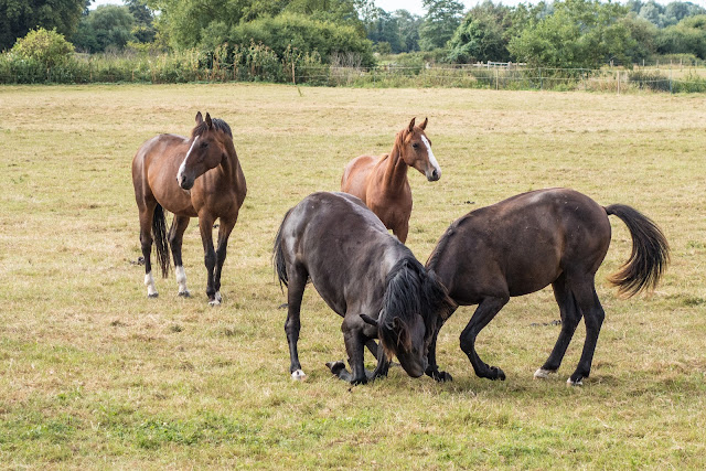
Do horses play?

While out for a walk today (a rather dull morning), I came across these horses chasing around a field and then stopping to engage in what looked like playful activities, before galloping away again.


I suppose they are playing as they were watched, and followed by the two horses in the background.


Anyway, it made for some good images I thought.

Home    Forward   Back