Thursday, 10 November 2016

Evolution of our garden

Our rear garden was a source of frustration from the time we moved in to our bungalow. Although we made the most of the space as it was and had a small lawn with a few plants, it was not as we would have wished. As well as the garden needing some reconstruction, the conservatory  was small and the worse for wear, so the two things came together in 2016 with a grand project, captured here on a few images. The results - well see below!


Starting point - the small conservatory and the steps and slabs which dominated the area.


Facing the other direction, we have the area that Rosey turned into a small flower/lawn area.


This is how it finished, thanks to a lot of hard work by Rosey. Then, time to move on.....


Demolition time! Where has the conservatory gone? plus all the furniture? What a lovely fence!


Someone is preparing for action by the looks of the building plant beginning to appear.


Re-construction has started as our new conservatory takes shape.


`Lo and behold` a new fence with a new gate - and in a different position.


The old shed has gone, the soil has begun to shift, and more slabs have appeared in a pile.


Trench dug for the retaining wall dug and more soil heaped up. Also the blocks for the wall are ready in a pile by the fence.


Danny`s tools and markers in place ready to start building the retaining wall.


The conservatory is finished  and the retaining wall takes shape. All that soil to remove!


Slabs re-appear, properly laid. The shape of the three tiered beds become apparent.


The path to the newly positioned gate appears.


How much cleaner and neater the whole garden appears!


New shed! Some initial planting and the end is in sight.


The finished article. We are really pleased how it has turned out, thanks in large part to the vision of Danny and his landscaping skills.


Home    Forward     Back


Saturday, 24 September 2016

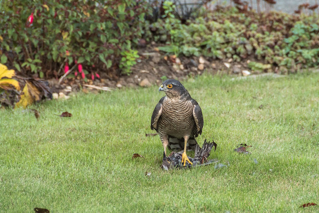
Sparrowhawk with kill

Just looked out of the window and sitting on the lawn was this Sparrowhawk having just brought down his prey which was still struggling to get away. Brutal as it might seem, this is nature and repeated millions of times all over the planet by numerous creature, every day.


Images taken with Nikon D5500 and Nikon 18-200 mm lens.


Home    Forward     Back


Wednesday, 14 September 2016

Sandymouth and Welcombe Mouth

Today we decided to walk along the coastal path and just soak up the glorious day. This looked like a lovely long beach with the prospect of a walk along a short part of the Coastal path.


We were not disappointed as, on a glorious day, we arrived at Sandymouth.


As you can see, there were very few people about, apart from the odd couple walking along the Coastal path like us, toward Northcott Mouth. 


A walk back along the beach was planned but was abandoned when, on composing this picture, we were surprised by a fast incoming tide and ended up with very wet feet. It was funny though! 
The reason we were taking picture of this particular rock formation was the apparent presence of `coral` formations on it? Anyway, back up onto the cliffs and trying to dry out the feet on the way back. 


This little creature posed for a few moments. 

A cup of coffee and a sandwich of crab (a bit disappointing), and we made our way toward Welcombe Mouth - a place we had visited before. On the way out, we stopped for a photograph of the dishes which make up GCHQ Bude, formerly called the Composite Signals Organisation (CSO). Station Morwenstow, is a satellite ground station and eavesdropping centre located between the small villages of Morwenstow and Coombe, operated by the British signals intelligence service (GCHQ), on the site of the former World War II airfield, RAF Cleave. 


A farmer carrying out the age old process of bringing in the harvest while the latest technology sits on the hills in the distance. This is a GCHQ listening post. 


On a previous holiday we stayed near Welcombe Mouth, so we looked forward to a re-visit, and were not disappointed. 


The small stream that cascades onto the beach, and like so much of the Cornish coast, in a secluded spot with rarely another person to be seen. 


It's just a rather pleasant, quiet spot. So ends our week in North Cornwall. Not the best of weather but nothing to stop us getting about. And now to face the long journey home! 


Home    Forward     Back

Tuesday, 13 September 2016

The Edge of Bodmin

There were a few places that we had earmarked for today and the first ones were really just plucked from the map - `Picturesque village.` Well, we had to have a look at that one!


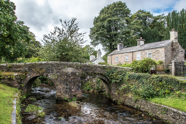
The village in question, on the edge of Bodmin, was Altarnum which had this wonderful packhorse bridge, and a magnificent church, perched at the top of the village. Well worth a visit.


A packhorse bridge is a bridge intended to carry pack horses (horses loaded with side bags or panniers) across a river or stream. Typically a packhorse bridge consists of one or more narrow (one horse wide) masonry arches, and has low parapets so as not to interfere with the horse's panniers. Multi-arched examples sometimes have triangular cutwaters that are extended upwards to form pedestrian refuges. 
Packhorse bridges were often built on the trade routes (often called packhorse routes) that formed major transport arteries across Europe and Great Britain until the coming of the turnpike roads and canals in the 18th century. Before the road-building efforts of Napoleon, all crossings of the Alps were on packhorse trails. Travellers' carriages were dismantled and transported over the mountain passes by ponies and mule trains. 


The village is dominated by the 15th C church of St Nonna (strange!) Measuring the tower height from the ground to the top of the pinnacles is over 100ft! 


From Altarnum it was a short hop across to the next village whose claim to fame is regarding a certain John Wesley. He was was an Anglican cleric and theologian who, with his brother Charles and fellow cleric George Whitefield, founded Methodism. Throughout his life, Wesley remained within the established Anglican church, insisting that the Methodist movement lay well within its tradition. In his early ministry, Wesley was barred from preaching in many parish churches and the Methodists were persecuted; he later became widely respected and, by the end of his life, had been described as "the best loved man in England" 
The cottage looks like a million others in Cornwall but its fame lies in the following story: On their first trip to Cornwall with John Wesley in 1743, two of his companions, John Nelson and John Downes, stopped at stonemason Digory Isbell's cottage to seek hospitality. 
They were welcomed by his wife, Elizabeth. Nelson called again as he was leaving Cornwall and reportedly preached to some 300 people. 
After that Wesley was also a regular lodger, and so Digory Isbell added a two-room 'Prophet's Chamber' to his cottage where Wesley and his preachers both stayed and preached. 
The lower room of the Chamber is thought to be the smallest Methodist preaching place in the world. 


In the garden can be seen the following Biblical text. 


And of course, the plaque on the wall for the tourists - (us!) 


Bodmin is a great place for wind, and this wind turbine looked good against the beautiful sky. 


On leaving John Wesley behind we made our way toward Bolventor, the site of Jamaica Inn. This I was looking forward to seeing, as one of my favourite books is Daphne du Maurier's 1936 novel Jamaica Inn. I had an image in my mind of an inn deep in Bodmin Moor, isolated and wild. What a contrast to reality! 
Today it is on a main road and is a very busy place. It is, to be true an 18th century Inn, and the surrounding moorland is bleak, but the illusion is shattered! 


One of the best bits was the sign showing a smuggler, an occupation described in the book and once widespread in that area. 


That evening we were going to drive to Crackington Haven, but somehow took a wrong turning. After some twisty turns and a very scary descent we arrived at this charming bay called Millook. 
My first image (above) was of an old boat leaning against a shed, just catching the last of the sun. 


As the sun dipped, the sky and beach were bathed in a beautiful light. I guess this isolated spot would be less secluded in daytime, but tonight, except for three young people (below) wandering past magnificent cliffs, we were on our own. The sunset (above) was the best view of the evening but all in all, a beautiful spot - if you can stand the descent!!


The beautiful patterns of the cliff structures 

Home    Forward     Back

Launceston and The Hurlers

Set on a large natural mound, Launceston Castle dominates the surrounding landscape. Begun soon after the Norman Conquest, its focus is an unusual keep consisting of a 13th-century round tower built by Richard, Earl of Cornwall, inside an earlier circular shell-keep. The tower top can be reached via an internal staircase but once reached, offers breathtaking views of the historic town and countryside. (See below)


Once the administrative headquarters for the Earl of Cornwall, it was a significant location where control could be kept over the various estates in the area.

The castle has a colourful history as a prison of which George Fox, founder of the Quakers, was the most famous prisoner. He suffered harsh confinement here in 1656. Launceston Castle was also used as the base for the Cornish Royalist defence of the county
Prince Charles was officially proclaimed Duke of Cornwall at Launceston Castle in 1973. As part of his feudal dues there was a pair of white gloves, gilt spurs and greyhounds, a pound of pepper and cumin, a bow, one hundred silver shillings, wood for his fires, and a salmon spear.


Part of the Southern gatehouse now used as the approach from the town.


This old water pump is in the grounds of the castle but so far I have no information as to date etc.


Approaches to the castle


So that's how it worked! Plaque on the castle wall.


The Church of St Mary Magdalene stands in the very centre of the medieval town of Launceston, watched over by the ruins of the 12th-century castle. Completed in 1524, the exterior granite stonework exhibits supremely intricate carvings, which Buckler details very well in his drawing. The tower is said to have held the first public clock in Cornwall, which was installed in 1431. Records show that the clock face was renovated in 1888 for the sum of £58 17s 6d by a Birmingham clock restorer.


Some 150 prehistoric stone circles have been identified in England, of which 16 are to be found on Bodmin Moor, the largest of the Cornish granite uplands. Of these, The Hurlers are the most fascinating.
The close grouping of three Late Neolithic or Early Bronze Age stone circles is extremely rare in England, but a grouping of three such regular circles is unique.
The monument, which was excavated in the 1930s, consists of three adjacent stone circles aligned north-east to south-west. To the west is a pair of outlying upright stones standing close together, known as the Pipers.
Of the northern circle 15 original stones are visible, and excavation revealed the buried holes for a further ten, now represented by marker stones. The regular spacing of the stones suggests there would have been five more, giving 30 in all.
A strip of granite paving, found in excavation, ran between this and the central circle.
The central circle, the best preserved of the three, has 14 original stones and 14 markers. All the stones were hammered smooth, and the chippings were deposited nearby. The southern circle, which has not been excavated, is the least well preserved: it has nine original stones of which seven have fallen.
Stone robbing has damaged all the circles to some extent, while the introduction of cattle on to Bodmin Moor has resulted in many of the stones falling over: cows use them as scratching posts, eroding the ground and undermining them.
The small pits visible within the southern and central circles, and a slight bank crossing the central circle, are the remains of post-medieval tin mining.


Some more of the stones. 


The day that we arrived at Minion (yes, really!) it was dull, there was not a hint of bright weather, this just gave the area a real dramatic atmosphere.


This rugged, windswept and mostly treeless area sits high up in a remote but beautiful corner of Bodmin Moor. Rising dramatically from the surrounding plain, the granite dome of Caradon Hill dominates the area and is encircled by engine houses, chimney stacks, thousands of tonnes of waste rock from the various mines and quarries, and the trackbed of the Liskeard & Caradon Railway.
This is a story of boom and bust: the rise of copper mining here established new settlements and expanded others, but the explosion of mining activity within this formerly isolated landscape was to last barely 50 years; large-scale mining for copper had essentially ceased by 1890.
The remoteness of the area means it is a wonderful place to escape the crowds, cycling or on foot, and discover wide open moorland, unique natural habitats, and ancient and industrial landscapes.


Home    Forward     Back