Tuesday, 13 September 2016

The Edge of Bodmin

There were a few places that we had earmarked for today and the first ones were really just plucked from the map - `Picturesque village.` Well, we had to have a look at that one!


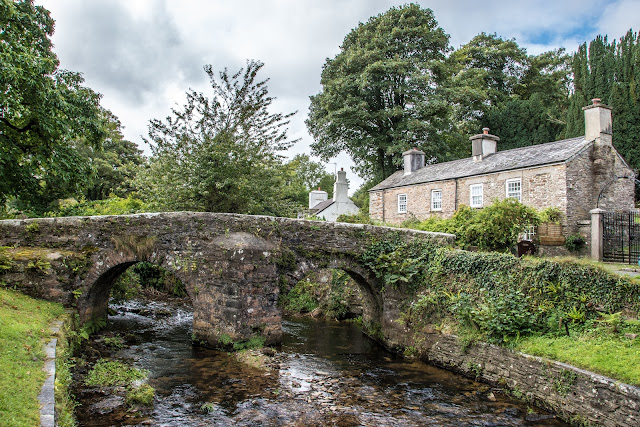
The village in question, on the edge of Bodmin, was Altarnum which had this wonderful packhorse bridge, and a magnificent church, perched at the top of the village. Well worth a visit.


A packhorse bridge is a bridge intended to carry pack horses (horses loaded with side bags or panniers) across a river or stream. Typically a packhorse bridge consists of one or more narrow (one horse wide) masonry arches, and has low parapets so as not to interfere with the horse's panniers. Multi-arched examples sometimes have triangular cutwaters that are extended upwards to form pedestrian refuges. 
Packhorse bridges were often built on the trade routes (often called packhorse routes) that formed major transport arteries across Europe and Great Britain until the coming of the turnpike roads and canals in the 18th century. Before the road-building efforts of Napoleon, all crossings of the Alps were on packhorse trails. Travellers' carriages were dismantled and transported over the mountain passes by ponies and mule trains. 


The village is dominated by the 15th C church of St Nonna (strange!) Measuring the tower height from the ground to the top of the pinnacles is over 100ft! 


From Altarnum it was a short hop across to the next village whose claim to fame is regarding a certain John Wesley. He was was an Anglican cleric and theologian who, with his brother Charles and fellow cleric George Whitefield, founded Methodism. Throughout his life, Wesley remained within the established Anglican church, insisting that the Methodist movement lay well within its tradition. In his early ministry, Wesley was barred from preaching in many parish churches and the Methodists were persecuted; he later became widely respected and, by the end of his life, had been described as "the best loved man in England" 
The cottage looks like a million others in Cornwall but its fame lies in the following story: On their first trip to Cornwall with John Wesley in 1743, two of his companions, John Nelson and John Downes, stopped at stonemason Digory Isbell's cottage to seek hospitality. 
They were welcomed by his wife, Elizabeth. Nelson called again as he was leaving Cornwall and reportedly preached to some 300 people. 
After that Wesley was also a regular lodger, and so Digory Isbell added a two-room 'Prophet's Chamber' to his cottage where Wesley and his preachers both stayed and preached. 
The lower room of the Chamber is thought to be the smallest Methodist preaching place in the world. 


In the garden can be seen the following Biblical text. 


And of course, the plaque on the wall for the tourists - (us!) 


Bodmin is a great place for wind, and this wind turbine looked good against the beautiful sky. 


On leaving John Wesley behind we made our way toward Bolventor, the site of Jamaica Inn. This I was looking forward to seeing, as one of my favourite books is Daphne du Maurier's 1936 novel Jamaica Inn. I had an image in my mind of an inn deep in Bodmin Moor, isolated and wild. What a contrast to reality! 
Today it is on a main road and is a very busy place. It is, to be true an 18th century Inn, and the surrounding moorland is bleak, but the illusion is shattered! 


One of the best bits was the sign showing a smuggler, an occupation described in the book and once widespread in that area. 


That evening we were going to drive to Crackington Haven, but somehow took a wrong turning. After some twisty turns and a very scary descent we arrived at this charming bay called Millook. 
My first image (above) was of an old boat leaning against a shed, just catching the last of the sun. 


As the sun dipped, the sky and beach were bathed in a beautiful light. I guess this isolated spot would be less secluded in daytime, but tonight, except for three young people (below) wandering past magnificent cliffs, we were on our own. The sunset (above) was the best view of the evening but all in all, a beautiful spot - if you can stand the descent!!


The beautiful patterns of the cliff structures 
Home    Forward     Back

Launceston and The Hurlers

Set on a large natural mound, Launceston Castle dominates the surrounding landscape. Begun soon after the Norman Conquest, its focus is an unusual keep consisting of a 13th-century round tower built by Richard, Earl of Cornwall, inside an earlier circular shell-keep. The tower top can be reached via an internal staircase but once reached, offers breathtaking views of the historic town and countryside. (See below)


Once the administrative headquarters for the Earl of Cornwall, it was a significant location where control could be kept over the various estates in the area.

The castle has a colourful history as a prison of which George Fox, founder of the Quakers, was the most famous prisoner. He suffered harsh confinement here in 1656. Launceston Castle was also used as the base for the Cornish Royalist defence of the county
Prince Charles was officially proclaimed Duke of Cornwall at Launceston Castle in 1973. As part of his feudal dues there was a pair of white gloves, gilt spurs and greyhounds, a pound of pepper and cumin, a bow, one hundred silver shillings, wood for his fires, and a salmon spear.


Part of the Southern gatehouse now used as the approach from the town.


This old water pump is in the grounds of the castle but so far I have no information as to date etc.


Approaches to the castle


So that's how it worked! Plaque on the castle wall.


The Church of St Mary Magdalene stands in the very centre of the medieval town of Launceston, watched over by the ruins of the 12th-century castle. Completed in 1524, the exterior granite stonework exhibits supremely intricate carvings, which Buckler details very well in his drawing. The tower is said to have held the first public clock in Cornwall, which was installed in 1431. Records show that the clock face was renovated in 1888 for the sum of £58 17s 6d by a Birmingham clock restorer.


Some 150 prehistoric stone circles have been identified in England, of which 16 are to be found on Bodmin Moor, the largest of the Cornish granite uplands. Of these, The Hurlers are the most fascinating.
The close grouping of three Late Neolithic or Early Bronze Age stone circles is extremely rare in England, but a grouping of three such regular circles is unique.
The monument, which was excavated in the 1930s, consists of three adjacent stone circles aligned north-east to south-west. To the west is a pair of outlying upright stones standing close together, known as the Pipers.
Of the northern circle 15 original stones are visible, and excavation revealed the buried holes for a further ten, now represented by marker stones. The regular spacing of the stones suggests there would have been five more, giving 30 in all.
A strip of granite paving, found in excavation, ran between this and the central circle.
The central circle, the best preserved of the three, has 14 original stones and 14 markers. All the stones were hammered smooth, and the chippings were deposited nearby. The southern circle, which has not been excavated, is the least well preserved: it has nine original stones of which seven have fallen.
Stone robbing has damaged all the circles to some extent, while the introduction of cattle on to Bodmin Moor has resulted in many of the stones falling over: cows use them as scratching posts, eroding the ground and undermining them.
The small pits visible within the southern and central circles, and a slight bank crossing the central circle, are the remains of post-medieval tin mining.


Some more of the stones. 


The day that we arrived at Minion (yes, really!) it was dull, there was not a hint of bright weather, this just gave the area a real dramatic atmosphere.


This rugged, windswept and mostly treeless area sits high up in a remote but beautiful corner of Bodmin Moor. Rising dramatically from the surrounding plain, the granite dome of Caradon Hill dominates the area and is encircled by engine houses, chimney stacks, thousands of tonnes of waste rock from the various mines and quarries, and the trackbed of the Liskeard & Caradon Railway.
This is a story of boom and bust: the rise of copper mining here established new settlements and expanded others, but the explosion of mining activity within this formerly isolated landscape was to last barely 50 years; large-scale mining for copper had essentially ceased by 1890.
The remoteness of the area means it is a wonderful place to escape the crowds, cycling or on foot, and discover wide open moorland, unique natural habitats, and ancient and industrial landscapes.


Home    Forward     Back

Monday, 12 September 2016

Tintagel and Boscastle

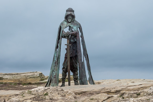
One of the reasons we found accommodation in this area of North Cornwall, was the proximity of Tintagel Castle. Many great images have been taken off the area and many legends abound, so a visit was definitely for today. The many legends are centered around the mythical King Arthur, and I, like most boys, was introduced to him at an early age.

History and legend are inseparable at Tintagel. During the so-called Dark Ages (about the 5th to the 7th centuries AD) it was an important stronghold, and probably a residence of rulers of Cornwall. Many fragments of luxury pottery imported from the Mediterranean were left behind by those who lived here. 


Today, the mystical tale of King Arthur is one of the great themes of British literature. But is there any truth behind the myth and why has it become so influential throughout the centuries?
The King Arthur that we know today is a collection of different legends, written by different authors, at different times. They are all united by the common theme that King Arthur was a fifth century British general who fought against Anglo-Saxon tribes and ensured that Britain remained a paradise of the West. The first mention of King Arthur is in the History of the Britons, penned in 830, and attributed to an author called Nennius. 
He writes: Then in those days Arthur fought against them with the kings of the Britons, but he was commander in those battles. 
A more elaborate tale of King Arthur came about in the 11th century, when Geoffrey of Monmouth published his book The History of the Kings of Britain. Arthur’s entire life is outlined for the first time in this work, right from his birth at Tintagel, to his death, and the legendary figures of Guinevere and Merlin are introduced. This book had a tremendous impact at the time. To this day, approximately 200 manuscripts remain in existence. 
Then, with the marriage of Henry II of England to Eleanor of Aquitaine, the stories of Arthur began to bloom in the courts of France and the legend took on romantic and spiritual tones. It was within this context that the mysterious Holy Grail first appears in the work of French court writer Chretien de Troyes. 
However, despite the entrenchment of Arthur within Celtic folklore, evidence of his actual existence is slim. In the histories of the time, there is no mention of an Arthur. 
The consensus amongst most historians is that Arthur probably did exist, either as an individual or a composite of several individuals. Since many of the Dark Age heroes were real men upon whom mythical talent and position were often thrust by storytellers, there is a strong possibility that Arthur was a Dark Age warrior of the Celts from which the rest of the mythological superstructure was formed. 


So, on to some images I took on our visit to Tintagel. Some of the ruins showing the precarious situation the castle occupied. Shame it is now only a ruin as it would have looked spectacular, I am sure.
There is a small bridge that has to be crossed to get from the land part of the castle to the rocky headland on which most of the history of Tintagel is found. At some point, there was a complete link between the two, but it has crumbled into the sea.


Merlin`s cave on the foreshore. Well, good for tourism!!


Some of the rugged coastline nearby.


In the town of Tintagel is this lovely old Post Office building. This 14th C medieval longhouse is a most delightful small buildings. The ancient undulating roof and massive chimney stack lend character to a fascinating building. The central hall is open to the great oak trusses and slates of the roof. A pleasing collection of country furniture, fine needlework samplers and a charming garden all add interest. During Victorian times one room was used as the letter-receiving office for the village and so the house became known as the Old Post Office.


The Victorian Post Box.

Then on to the picturesque fishing village of Boscastle with its medieval past and distinctive natural harbour and one of Cornwall’s most romantic places. It is a village steeped in history, associated with authors and artists who have been inspired by its remoteness and rugged beauty. Boscastle was once a favourite haunt of author,Thomas Hardy, and the setting for one of his novels, A Pair of Blue Eyes. It was here that he met his wife, Emma. In fact, the restoration of nearby St Juliot Church was worked upon by Hardy when he was still a practising architect.


A model in the garden of the Post Office.


Looking back toward the village from near the harbour entrance.


…. then looking seaward from near the same point.


The River Valency as it runs through the lower part of the village.


Some of the village house set just back from the river. 

On 16 August 2004 an estimated 440 million gallons of water swept through the picturesque West Country town and led to the bursting of banks and the convergence of three rivers.
A total of 58 properties were flooded while four others were completely destroyed.
Around 100 people had to be plucked to safety by emergency teams, after mounting their roofs to escape the rising waters.
The town suffered millions of pounds worth of damage but as residents will also say of that day – it was astounding that nobody died.
http://www.bbc.co.uk/news/uk-england-cornwall-28523053 for more details of the devastation of 2004 when heavy localised rainfall – 89 mm of rain - fell in an hour. 
Following the devastation, 4.5 million pounds was spent locally on flood defences. A new Boscastle bridge with a new storm water culvert was built as part of the flood measures. 


Home    Forward     Back

Sunday, 11 September 2016

Beautiful Bude in North Cornwall

Day one of our holiday dawned with some cloud about, but a promise of sunshine. So today, a visit just along the coast to Bude, another place I have not visited.
Bude is Cornwall's most northern town and has been a popular seaside resort from Victorian times. In the l9th Century, the town was notorious for wreckers who plundered ship wrecked off the coast - over 80 vessels in the fifty year up to 1874. Not today, just tourists wrecking the place!


Bude has some good surfing beaches and was the site of the first life Saving Club. Today there were a few hardy souls trying to catch the waves. Mind you, I should be impressed by anyone who can surf, as I cannot even swim!


Next, some images of the beach huts. I just love the colours.


Watching the surfers, and anything else that moved, were these two Ravens. To quote the RSPB site "The raven is a big black bird, a member of the crow family. It is massive - the biggest member of the crow family. It is all black with a large bill, and long wings. In flight, it shows a diamond-shaped tail.
Ravens breed mainly in the west and north although they are currently expanding their range eastwards. Most birds are residents, though some birds - especially non-breeders and young birds - wander from their breeding areas but do not travel far."


Doggy paddle maybe?


I`ve got one!


Then a wander the cliff edge to see some of the interesting colours in the rocks.


What a holiday home this would be!


Then we wandered out to a rocky point which gave us a grandstand view of the whole beach and the waves crashing in the the other side. 


Gone for a swim.


We walked back along the beach to find a great place for coffee and cake and took time to photograph large numbers of geese which had stopped off, I suppose, for a rest before continuing migration to - who knows where?


Home    Forward     Back

Saturday, 10 September 2016

Crackington Haven

On leaving Bude we drove to Crackington Haven, the nearest bay to our holiday home. Apparently, many surfers tend to prefer the less popular beach of Crackington Haven and yes, they were there as well. And, no, I didn't get a photo!


Not a surfer, but Rosey checking her camera! In the background is Cornwall's highest cliff at 735 feet. There is Geocache at the top but my legs went weak at the thought!


More rock pools and colourful rock patterns. 

Some more history: 'Crackington' is a hybrid of Cornish and English 'Crack' means sandstone in Cornish and 'mutha tun' means river mouth farm in English. Located on part of the 600 mile South West Coast Path, Crackington is situated at the mouth of the picturesque valley which leads to Mineshop. It is of great geological importance with its carvoniferous rocks, which has even been given the name 'the Crackington Formation', for this reason the area has been designated a Site of Special Scientific Interest (SSSI), as well as an Area of Outstanding Natural Beauty. 
Crackington Haven was mainly used for the Quarrying of Slate. Large vessels would come in and beach themselves at mid tide, unload their cargo of limestone & coal, load up with slate taken from the cliffs and on the next high tide they would sail away. In the 19th Century plans were drawn up to build a harbour at Crackington, luckily these plans were abandoned leaving its unspoilt beauty relatively unchanged for centuries. 
Wrecks are said to have supplied much of the early building materials in Crackington. The rocky headlands claimed many boats all along the coast. If you walk around the rocks from Crackington Haven Beach off to the left, you may stumble across the last remaining parts of the WW2 S89 German E boat which broke tow whilst en route to Wales and washed up on Tremoutha Haven Beach on 5th October 1946. The engines are still visible and low tide for about three hours per day, please be careful not to get cut off by the tide. 
Crackington, along with Boscastle, suffered a great deal of damage in the flood of 16th August 2004. Shops, cafes and homes were flooded, cars washed out to sea, and the bridge suffered structural damage which has since been repaired. Crackington has never seen anything like it before. Seeing the peaceful village now, it is hard to believe that anything ever happened! The Cabin Cafe has a photo album showing the damage that occurred on that day, it is well worth a look. 


Just `round the corner` from Crackington Haven is the church of St Gennys, which is named after Saint Genesius. The church is built into a hillside, or so it seems! Note the sloping graveyard. 


... and is this the Priest's door? The door itself is very new. 

The cult of Genesius spread quickly from Arles into other parts of the empire, including Rome, where a titular church was built. It was then assumed that he was a Roman martyr: hence "Genesius of Rome". Later on, even more confusion helped to create an entirely fictional legend, in which he was a comedian who had converted to Christianity half-way through performing an anti-Christian satire, and was then beheaded. This latter story began in the 6th century at the latest. 
Having wondered who this Saint was, I checked with Wikipedia and found this: 
Genesius (Gennys) died as a martyr c. 303 AD. He is mentioned in several sources as having been martyred under the persecutions of Maximian and Diocletian. Genesius was a legal clerk, and on one occasion was so upset by the edict of persecution that he heard that he left his position. He went in search of baptism, but was not trusted by the bishop he found, who instead advised him that martyrdom was at least as good in the eyes of God. Genesius was eventually beheaded. 
The things you learn!! Now an obscure hamlet in North Cornwall has a church dedicated to him. Few churches in Cornwall can rival St. Gennys for its setting. Tucked under the lee of the cliff, and thus protected from the Atlantic gales, the church and its sloping graveyard command one of the finest views in North Cornwall, over Bude Bay and up the Bristol Channel to where Lundy Island can be seen. 


Well, here is the view, but I could not see Lundy. 


Home    Forward   Back