Wednesday, 5 May 2010

Fishguard and the beautiful hamlet of Cwm-yr-Eglwys

A visit today to the area above St Davids called Dinas Island peninsula, passing Fishguard on the way. Another stunning coastline, rather sparsely populated generally.


The port of Fishguard on a rather foggy day. What do you expect on the Welsh coast! Actually we have had amazing weather, so no complaints there.
The town is situated at the back of a north facing bay known as Fishguard Bay (Welsh: Bae Abergwaun) which offers protection from waves generated by prevailing westerly winds. It has a relatively mild climate due to its coastal position. The winds coming from the west or south-west have a determining influence on temperature and precipitation. 
Wildlife around Fishguard is rich with a wide variety of colourful wild flowers and sea mammals including the grey seal, porpoises and dolphins. The local birdlife include Eurasian curlew, common redshank and sanderling regularly foraging in the lower Fishguard Harbour and European stonechat, great cormorant and northern fulmar can be seen from the coastal path. Unfortunately we were only passing through on this occasion.


The village/Hamlet of Cwm-yr-Eglwys (English: Valley of the Church) 


Another view from above. The beautiful beach (tide is in here!) has earned a Seaside Award and a Green Coast Award, similar to a Blue Flag beach Award but for rural beaches with safe bathing.


Gannet swoops by. 


Ruins of Church of St. Brynach the Abbot in the village 

The church of St. Brynach is probable pre-Norman. The building suffered storm damage in 1850 and 1851 when the chancel was destroyed by the sea, the church footings left hanging over an abyss. The graveyard was severely damaged, the level being reduced by at least three feet, exposing human remains in large quantity. The great storm of October 1859 (the Royal Charter Storm) removed the church roof and damaged the walls. The building was abandoned immediately. In 1880, the remaining ruins were demolished apart from the west entrance wall. 
Just remind me, did they have global warming then?? 


The lone runner - a great place to get, or keep, fit. 


Home or Next

Tuesday, 4 May 2010

Exploring St Annes Head

St Anne`s Head protrudes from the bottom of Pembrokeshire - if you excuse the expression! This was the area we had decided to explore today, starting on the left side at Westdale Bay and making our way along the coast in an anti-clockwise direction. As with most bays and inlets, there was hardly another soul about.


Westdale Bay - not a soul in sight.


Wheatear sitting by the fence.


Around the area of Frenchman's Bay with the beautiful rock formations.


Wonderful rock formation at St Anne`s Point


St. Ann’s Head Lighthouse was built in 1844 to guide shipping bound for Milford Haven, replacing two leading lights established in 1714.
Trinity House approved in principal a private application to build a coal-fired light at St. Ann's Head in the second half of the 17th century to guide Milford-bound shipping; it was to be supported by voluntary payment of dues. However, the owners extracted dues illegally from shipowners and the light—the only one on the west coast—was discontinued. 40 years passed before another light was established although it is said that sea traders petitioned many times for the area to have lights.
On 15 March 1712 a patent was granted to Trinity House to build a lighthouse at St. Ann's Head. Trinity House in turn—as was its policy at the time—leased it to the owner of the land, Joseph Allen, who agreed to build two lighthouses and keep them in good repair. The terms of the lease were for 99 years at an annual rent of £10; to help maintain the lights, Allen was permitted to collect dues from the shipmasters at Milford Haven amounting to one penny per ton of cargo on British vessels and two pence on foreign vessels. Allen established two towers near the old disused lighthouse and lit coal fires on them in June 1714. St. Ann’s Head Lighthouse was automated and de-manned in 1998. The lighthouse is now monitored and controlled from Trinity House’s Planning Centre in Harwich, Essex.


Henry Tudor’s landing site

Further around the coast we came across this plaque with an important piece of history on it. On 7 August 1485, Henry Tudor landed here at Mill Bay, at the mouth of the Milford Haven waterway. He was 28 years old and had lived most of his life in exile in France. With him were c.2,000 French mercenaries, funded by the King of France. Little more than a fortnight later, his supporters had defeated King Richard III at Bosworth, near Leicester, and he became King Henry VII. The Tudor dynasty which followed had a profound influence on Britain as we know it today. 
Why did Henry choose Mill Bay? Familiarity was one reason. Henry was born in Pembroke Castle, on the opposite side of the Milford Haven waterway. His uncle, Jasper Tudor, was nominally Earl of Pembroke and had maintained contact with people in the area while bringing up his nephew in France. 
Another reason for choosing Mill Bay was to avoid detection by the king’s observers at Dale Castle, some 3km further north. Inevitably, news of Henry’s landing travelled quickly – the king knew about it by 11 August. Crucially, however, the decision to land in this secluded bay allowed the fledgling army to come ashore unopposed. 
It was also imperative for Henry to start his march to Bosworth in a sympathetic region, because the army would quickly need provisions from supportive locals as well as extra soldiers from gentry who would rally to his cause. His strategy paid off, and he received a hearty welcome in Haverfordwest, the first major town on his route. 
His chief supporter in Wales was Rhys ap Thomas, whose homes included Carew Castle, near Pembroke. He marched across Wales via a different route to gather more soldiers for the battle. The story was later romanticised to portray Rhys standing at Mill Bay to welcome Henry. 


Mill Bay. Looking back toward the bay where Henry Tudor landed from France.


Last, but not least, Watwick Bay. Then home for a rest! Not a lot to to be said about the area, but a beautiful, peaceful place to wander and stand and stare. That's what life should have in it surely for all of us - a time to do just that?


Home or Next

Monday, 3 May 2010

Solva and coastal views on a walk nearby

Solva is another pretty little village with a beautiful mooring for boats, being just off the coast in the mouth of the estuary of the River Solva. The village itself we did not explore but opted for a walk up to the top of the headlands (the Gribin) for the magnificent views. We were fortunate again to have a beautiful day for our walk.
So, some images of the area, starting with a couple of boats and, in the background, the lime kilns. Built in the late 18th or early 19th Century, of the original 12 lime kilns, seven remain. Lime, brought in by sea from Milford Haven, was used to enrich the poor local soil. These lime kilns - at the foot of the Gribin - were the last to be used, in 1900.


Boats at anchor in the estuary.


Thrush in a bush by the pathway, singing his little heart out!


Nearing the top of The Gribin and looking toward the sea.


And a similar view.


The looking down toward the town and the harbour.


Along the pathway nearby, you can see the Thrift which grows in abundance on these cliffs.


RAF Mountain Rescue team out training.


A great day in a beautiful area - I am sure we will return. (We did in 2015. My Blog )


Home or Next

Saturday, 1 May 2010

Pembrokeshire - St Davids` and on to Little Haven

Our first visit to Pembrokeshire started at St Davids, the smallest city in the UK in terms of geographical area and population. It is an important ecclesiastical site because of its many historic associations.

The monastic community was founded by Saint David, Abbot of Menevia, who died in 589. Between 645 and 1097, the community was attacked many times by raiders, including the Vikings. 
However, by 1115, with the area under Norman control, King Henry I of England appointed Bishop Bernard as Bishop of St Davids. He began to improve life within the community, and commenced construction of a new cathedral. In 1123, Pope Calixtus II granted Bishop Bernard's request to bestow a papal privilege upon St Davids, making it a centre of pilgrimage for the Western world, the Pope decreeing that "Two pilgrimages to St Davids is equal to one to Rome, and three pilgrimages to one to Jerusalem". The new cathedral was quickly constructed and Bishop Bernard consecrated it in 1131. Henry II of England's visit in 1171 saw the following of David increase and the need for a larger cathedral. 
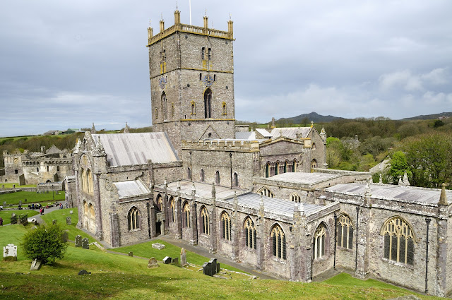
The present cathedral was begun in 1181 and completed not long after. Problems beset the new building and the community in its infancy, the collapse of the new tower in 1220 and earthquake damage in 1247/48. 


St Davids Cathedral


Ruins of The Bishops Palace adjacent to St Davids Cathedral, now a picturesque ruin. 

The Bishops Palace has been described as the work of a series of 'builder bishops', with work carried out in the late 13th and 14th centuries.
In 1284, King Edward I visited St Davids on a pilgrimage and this visit may have inspired some earlier work because Bishop Thomas Bek, who served from 1280–93, was among his former statesmen. Bishop Bek was responsible for construction of the chapel in the south-west corner, the hall, the private apartments and the gate. 
The man responsible for much of the site that can be seen today was Bishop Henry de Gower (1328–47). He carried out major works in the cathedral itself, built the Great Hall with wheel window in the east gable, the distinctive arcaded parapet and the porch. Gower's main legacy is the two great ranges. The east range – the simpler of the two – was the first to be built. The much grander south range was built for entertaining. 
The beginning of the Reformation heralded the decline of the Bishops Palace. In 1536 Bishop William Barlow stripped the lead from the roof. Legend has it that he used the money to pay for the dowries of his five daughters. However, as he had no daughters at that time, and the first marriage of a daughter did not occur until about 25 years later, the story was probably fabricated by his many enemies. He made so much money from this that a sixteenth-century account said that more than twelve years revenue of the bishopric would have been needed to cover the cost of replacing it, and the building fell into disrepair. Bishops stayed less at St Davids and, by the middle of the 16th century, the chief episcopal residence had been relocated to Abergwili, Carmarthenshire. In 1616, Bishop Richard Milbourne applied for a licence to demolish some of the buildings. By 1678, when another licence for demolition was sought, the palace was considered beyond repair. 


One cheeky Jackdaw checks if we have dropped any food. I think he took up position where we had stopped for lunch - as they do!.


Drinker Moth Caterpillar. Seen in the grass along the path side.


Thrift growing in some profusion on the tops of the cliffs by the pathways - beautiful!


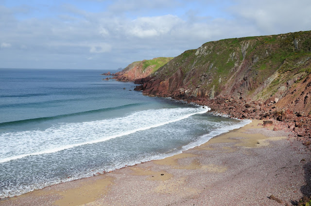
The coastline in Pembrokeshire is stunning and is one of my all time favourite places to visit. There are just miles and miles of beauty and solitude


Walkers on the Pembrokeshire Coastal path. Many people walk this beautiful area, and who can blame them?


So we arrive in Little Have which is our base for this holiday. First port of call, the coast!


One of the cave like depressions in the cliff side - Little Haven.


Another sweeping view of Little Haven beach.

Home or Next

Friday, 23 April 2010

A view of Chester - Part 2 of 2

On our wander around Chester, not only the buildings were interesting, but also the people. Suddenly spotted this elderly lady with her elderly camera, standing in front to me, photographing something. Just had to take a picture of her! We had a conversation for a few minutes, and it turned out that she had several other old cameras in a carrier back in her hand!


The Old Photographer


A bronze sculpture of a Elephant, unveiled on Tuesday 16th March 2010 opposite the Town Hall. It is called Janya, and is a baby Indian Asian calf. It was donated by Chester zoo. Next we moved onto Chester Cathedral.
The C7th Mercian King, Wulfhere, is reputed to have founded a timber church on this site dedicated to St Peter and St Paul, but it was his daughter, Werburgh, who really put Chester on the map. She renounced her royal status to become a nun at Ely Abbey. Many miracles were attributed to her during her lifetime, including restoring back to life a goose that had been stolen and eaten. 
She was buried in Staffordshire and her tomb rapidly became a place of pilgrimage. Following the threat of Danish raids in the C9th her relics were brought to Chester as a place of safety and were placed in the Church of St Peter and St Paul. Queen Ethelfleda, the grand daughter of Alfred the Great, founded a monastery in Chester and rededicated the church to St Werburgh. The new monastery continued to enjoy royal patronage and flourished. A splendid shrine was built in her honour. 


The Water of Life


I loved this statue in the Cathedral cloisters. The piece was designed for the Cloister Garden of Chester Cathedral in association with the 900th Anniversary celebrations of the foundation of the Benedictine Abbey of St Werburgh, on this site in 1092.
The water feature depicts (if you know the story) "the encounter between Jesus and the Woman of Samaria, showing their shared bowl overflowing with water. The theme of water also suggests a link to how the Benedictine monks water supply was at the centre of the cloister garden." 


Looking toward the great west window in Chester cathedral. It is Perpendicular Gothic with 20th-century stained glass by W. T. Carter Shapland (1961) as the Victorian stained glass was blown out by a bomb in 1941.The picture shows the massive space inside this building. 


And facing the other way toward the altar


The Gothic Chapter House 

Chester was the last English city to fall to the Normans in 1069. To bring the area firmly under Norman control, William I appointed his nephew, Hugh d’Avranches, as Earl of Chester. He built Chester Castle and transformed the Saxon Church into a large and well endowed Benedictine Monastery, with a Norman church around the shrine of St Werburgh. Building began at the east end where the monks held services and gradually extended west. Work began on the domestic buildings including the cloisters.


Elephant and castle bench ends - note the feet of a horse, demonstrating that the carver had learnt of elephants by word of mouth.


During the Commonwealth, the Puritans smashed all the stained glass and replaced with plain glass. The hands of the Greene monument (above) in the nave were removed because they were joined in prayer, which was regarded as a popish gesture. 


The space beneath the south west tower was set up as the Consistory court in 1636. The court dealt with all the legal work of the diocese, including handling wills and probate, issues of matrimony as well as heresy, blasphemy and slander. This is the only surviving court in England. The judge, called the Chancellor, sat at the canopied seat at the head of the table, with a clerk on either side. The other officers of the court sat round the table. The Apparitor was responsible for the smooth running of the court and sat in the high seat in the corner, where he could see everything going on.


Part of the Cloisters


A view of the Shropshire Union Canal from the City walls. 

The Shropshire Union Canal, nicknamed the "Shroppie" is a navigable canal in England. The Llangollen and Montgomery canals are the modern names of branches of the Shropshire Union system and lie partially in Wales.
The canal lies in the counties of Staffordshire, Shropshire and Cheshire in the north-west English Midlands. It links the canal system of the West Midlands, at Wolverhampton, with the River Mersey and Manchester Ship Canal at Ellesmere Port, Cheshire, 66 miles (106 km) distant. It runs southeast from Ellesmere Port on the River Mersey to the Staffordshire and Worcestershire Canal at Autherley Junction in Wolverhampton.
The canal was the last trunk narrow canal route to be built in England. It was not completed until 1835 and was the last major civil engineering accomplishment of Thomas Telford.


Chester Castle with some history, courtesy of English heritage.

Chester Castle was founded by William the Conqueror in 1070 and became the administrative centre of the earldom of Chester. The first earth and timber ‘motte-and-bailey’ castle probably only occupied the area of the inner bailey. In the 12th century it was rebuilt in stone and the outer bailey added.
I wondered what this meant so turned to Wikipedia and learnt `A motte-and-bailey castle is a fortification with a wooden or stone keep situated on a raised earthwork called a motte, accompanied by an enclosed courtyard, or bailey, surrounded by a protective ditch and palisade. Relatively easy to build with unskilled, often forced, labour, but still militarily formidable, these castles were built across northern Europe from the 10th century onwards, spreading from Normandy and Anjou in France, into the Holy Roman Empire in the 11th century. The Normans introduced the design into England and Wales following their invasion in 1066. Motte-and-bailey castles were adopted in Scotland, Ireland, the Low Countries and Denmark in the 12th and 13th centuries. By the end of the 13th century, the design was largely superseded by alternative forms of fortification, but the earthworks remain a prominent feature in many countries` So now we know!
In 1237 the last earl died and the castle, with the earldom, was taken over by the king. In 1265, during the Barons’ War, it was held for ten weeks by supporters of Simon de Montfort against the men of Prince Edward, son of Henry III.
During the reigns of Henry III and Edward I the castle served as the military headquarters for the conquest of Wales and much building was carried out, especially in the outer bailey. In the later medieval period the monarch rarely stayed at the castle, but it continued to serve as the centre for county administration. We were limited in our time in the beautiful City of Chester so we only took this one image and did not explore the interior. perhaps another day.


Another view of Chester Cathedral, seen from our wall walk, 


On the Shropshire Union Canal we came across this step lock.


Watching people operating the lock and maneuvering their barge through it.

A great part of the world that we had not visited before. We need to re-visit some more of it as time was somewhat limited. One for the diary!